Tagliacozzo
Appearance
Tagliacozzo | |
|---|---|
| Comune di Tagliacozzo | |
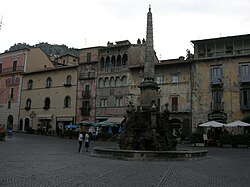
 Piazza dell'Obelisco. | |
| Country | Italy |
| Region | Abruzzo |
| Province | L'Aquila (AQ) |
| Frazioni | Colle San Giacomo, Gallo di Tagliacozzo, Nuovo Borgo Rurale, Oriente, Poggetello, Poggio Filippo, Roccacerro, San Donato di Tagliacozzo, Sfratati, Sorbo, Tremonti, Villa San Sebastiano Marsia |
| Government | |
| • Mayor | Maurizio Di Marco Testa |
| Area | |
| • Total | 89.41 km2 (34.52 sq mi) |
| Elevation | 740 m (2,430 ft) |
| Population (31 January 2012)[2] | |
| • Total | 7,003 |
| • Density | 78/km2 (200/sq mi) |
| Demonym | Tagliacozzani |
| Time zone | UTC+1 (CET) |
| • Summer (DST) | UTC+2 (CEST) |
| Postal code | 67069 |
| Dialing code | 0863 |
| Patron saint | St. Peter |
| Saint day | 13 June |
| Website | Official website |
Tagliacozzo is a town and comune in the province of L'Aquila, Abruzzo, central Italy.
History
Tagliacozzo lies in an area inhabited in early historic times by the Aequi and the Marsi, although the first mentions of the town dates from the 11th century AD. Later it was a possession on the Orsini, who established a mint here. They were succeeded by the Colonna (local lords including Prospero and Marcantonio Colonna), who held the Duchy of Tagliacozzo until 1806.
Near the modern city (more precisely, near Scurcola Marsicana) was fought the Battle of Tagliacozzo (1268) between Conradin of Hohenstaufen and Charles I of Anjou.
Main sights
- The Palazzo Ducale (Ducal Palace), built by Roberto Orsini.
- The Convent of St. Francis, housing the tomb of Tommaso da Celano.
- Museo Orientale, with collections of Egyptian, Ethiopian and Eastern findings.
- 13th century fountain in Piazza dell'Obelisco, a national monument.
- Sanctuary of Maria Santissima dell'Oriente, on a hill 3 kilometres (1.9 mi) from town. It is cited as early as the 14th century.
People
- Andrea Argoli (1570–1657)
Notes and references
- ^ "Superficie di Comuni Province e Regioni italiane al 9 ottobre 2011". Italian National Institute of Statistics. Retrieved 16 March 2019.
- ^ All demographics and other statistics: Italian statistical institute Istat.
External links


