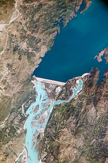
Tarbela Dam
This article needs additional citations for verification. (February 2011) |
| Tarbela Dam | |
|---|---|
 | |
| Construction cost | USD 1,497 Million [1] |
Tarbela Dam (Urdu: تربیلا بند) on the Indus River in Pakistan is the second largest dam in the world by structural volume. It is located in Haripur District, Khyber Pakhtunkhwa, about 50 kilometres (31 mi) northwest of Islamabad.[2]The dam is 485 feet (148 m) high above the riverbed. The dam forms the Tarbela Reservoir, with a surface area of approximately 250-square-kilometre (97 sq mi). The dam was completed in 1974 and was designed to store water from the Indus River for irrigation, flood control, and the generation of hydroelectric power.
Description
The project is located at a narrow spot in the Indus River valley, at Tarbela in Haripur, shortly located at the point from where the District Swabi starts. Here the river formerly split around a large island close to the left bank. The main dam wall, built of earth and rock fill, stretches 2,743 metres (8,999 ft) from the island to river right, standing 148 metres (486 ft) high. A pair of concrete auxiliary dams spans the river from the island to river left. The spillways, located on the auxiliary dams, in turn consist of two parts. The main spillway has a discharge capacity of 18,406 cubic metres per second (650,000 cu ft/s) and the auxiliary spillway, 24,070 cubic metres per second (850,000 cu ft/s). The outlet works are a group of four tunnels that have been cut through the valley wall at river right, for uses of hydropower generation and flow control. These tunnels were originally used to divert the Indus River while the dam was being constructed. IT WAS MAFE BHB JHBCD ZB BZ CJh c z cmn sb czxcBSa C A hydroelectric power plant on the right side of the main dam houses 14 generators fed with water from outlet tunnels 1, 2, and 3. There are four 175 MW generators on tunnel 1, six 175 MW generators on tunnel 2, and four 432 MW generators on tunnel 3, for a total generating capacity of 3,478 MW. Tarbela Reservoir is 80.5 kilometres (50.0 mi) long, with a surface area of 250 square kilometres (97 sq mi). The reservoir holds 11,600,000 acre-feet (14.3 km3) of water, with a live storage of 9,700,000 acre-feet (12.0 km3). The catchment area upriver of the Tarbela Dam is spread over 168,000 square kilometres (65,000 sq mi) of land largely supplemented by snow and glacier melt from the southern slopes of the Himalayas. There are two main Indus River tributaries upstream of the Tarbela Dam. These are the Shyok River, joining near Skardu, and the Siran River near Tarbela.
The Tarbela Dam is the second largest in terms of dam volume in the world.
Settlement of Tarbela Dam affectees
It has a reservoir area of about 260 square kilometers and about 82,000 acres land was acquired for its construction. The large reservoir of the dam submerged 135 villages, which resulted in displacement of a population of about 96,000 people. For the land and built-up property acquired under the Land Acquisition Act of 1984, a cash compensation of Rs 469.65 million was paid to the affectees. In the absence of a national policy, resettlement concerns of the affectees of Tarbela Dam were addressed on ad hoc basis.
Many affectees of the Tarbela Dam have still not been settled and not been given land as compensataion by the Government of Pakistan, accordance with its contractual obligations with World Bank.[3]
Life Span
Because the source of the Indus River is glacial meltwater from the Himalayas, the river carries huge amounts of sediment. The annual suspended sediment load is about 430 million tons per year. This means that, over time, the reservoir will fill. The useful life of the dam and reservoir was estimated to be somewhere around fifty years, since the dam's completion in 1976, meaning that the reservoir would have been full of sediment by 2030.
However, sedimentation has been much lower than predicted, and it is now estimated that the useful lifespan of the dam will be 85 years, to about 2060. [4]
See also
Notes
- ^ Tarbela Dam Costs
- ^ http://www.myswabi.tk/map&villages.html
- ^ "Settlement of Tarbela Dam affectees claims". Pakistan Economist. Retrieved 12 April 2011.
- ^ Lorrai, C and Pasche, N. 'Tarbela Dam-Case Study' Swiss Federal Institute of Technology Zurich: April 2007
