
Texas State Highway 276
 State Highway 276 | ||||
|---|---|---|---|---|
 | ||||
| Route information | ||||
| Maintained by TxDOT | ||||
| Length | 40.721 mi[1] (65.534 km) | |||
| Existed | 1960–present | |||
| Major junctions | ||||
| West end | ||||
| East end | ||||
| Location | ||||
| Country | United States | |||
| State | Texas | |||
| Counties | Rockwall, Hunt, Rains | |||
| Highway system | ||||
| ||||
State Highway 276 or SH 276 is a Texas state highway that runs from Rockwall east to Emory. This route was designated in 1960 between Rockwall and Quinlan, and was extended to its current terminus in 1990, replacing most of FM 35.
History
SH 276 was designated by 1938 as a route between US 285 southwest of Arno and Mentone. In 1946, another section from SH 115 to what was then SH 82 (now SH 18) in Kermit was added. Later that year, that section was transferred to SH 302. By 1953, SH 276 was transferred to SH 302.
Junction list
| County | Location | mi | km | Destinations | Notes |
|---|---|---|---|---|---|
| Rockwall | Rockwall | 0.0 | 0.0 | ||
| 1.8 | 2.9 | ||||
| | 4.7 | 7.6 | |||
| | 5.8 | 9.3 | |||
| | 6.4 | 10.3 | |||
| Hunt | | 11.8 | 19.0 | ||
| | 12.8 | 20.6 | |||
| | 16.9 | 27.2 | |||
| Quinlan | 18.8 | 30.3 | |||
| 19.3 | 31.1 | West end of SH 34 overlap | |||
| 19.8 | 31.9 | East end of SH 34 overlap | |||
| | 20.9 | 33.6 | |||
| Rains | East Tawakoni | 29.3 | 47.2 | ||
| | 32.1 | 51.7 | |||
| | 34.2 | 55.0 | |||
| | 39.8 | 64.1 | |||
| Emory | 41.1 | 66.1 | |||
1.000 mi = 1.609 km; 1.000 km = 0.621 mi
| |||||
Gallery
-
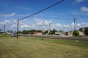
 State Highway 276 in Quinlan
 -
 State Highway 276 in West Tawakoni
 -
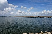 State Highway 276 crossing Lake Tawakoni on the Tawakoni Causeway
.jpg)
.jpg)

References
- ^ Transportation Planning and Programming Division (n.d.). "State Highway No. 276". Highway Designation Files. Texas Department of Transportation. Retrieved 2008-04-06.
This Texas road-related article is a stub. You can help Wikipedia by expanding it. |