Trail, Oregon
Appearance
Trail | |
|---|---|
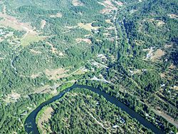
 An aerial image of Trail and the Rogue River | |
| Country | United States |
| State | Oregon |
| County | Jackson |
| Elevation | 1,430 ft (440 m) |
| Time zone | UTC-8 (Pacific (PST)) |
| • Summer (DST) | UTC-7 (PDT) |
| ZIP codes | 97541 |
| GNIS feature ID | 1151362 |
Trail is a census-designated place and unincorporated community in Jackson County, Oregon, United States. Although it is unincorporated, it has a post office with a ZIP code of 97541.[1][2] Trail lies at the intersection of Oregon Route 227 and Oregon Route 62, just north of Shady Cove and west of Lost Creek Lake, which is a reservoir of the Rogue River. Trail is located around the mouth of Trail Creek at the Rogue River.[3]
Climate
This region experiences warm (but not hot) and dry summers, with no average monthly temperatures above 71.6 °F. According to the Köppen Climate Classification system, Trail has a warm-summer Mediterranean climate, abbreviated "Csb" on climate maps.[4]
References
- ^ a b "Trail". Geographic Names Information System. United States Geological Survey, United States Department of the Interior. November 28, 1980. Retrieved December 8, 2013.
- ^ Zip Code Lookup
- ^ "Trail, OR". Google Maps. Retrieved December 8, 2013.
- ^ Climate Summary for Trail, Oregon

