
Tremont Street
This article needs additional citations for verification. (August 2009) |

Tremont Street is a major thoroughfare in Boston, Massachusetts.
Etymology
The name is a variation of one of the original appellations of the city, "Trimountaine," a reference to a hill that formerly had three peaks. Beacon Hill, with its single peak, is all that remains of the Trimountain. Much of the Trimountain was removed, and the earth used as fill to expand the Shawmut Peninsula. The two smaller peaks, Cotton Hill (or Pemberton Hill, at what is now Pemberton Square) and Mt. Whoredom (or Mt. Vernon, formerly at the location of the modern-day Louisburg Square) no longer exist.[1] The central peak, Sentry Hill, now called Beacon Hill, is smaller than the original peak, which reached approximately to the height of the top of the State House.
A British military map of Boston from 1775, prepared by a Lieut. Sir Thomas Hyde Page of His Majesty's Corps of Engineers, shows Beacon Hill, Mount Whoredom, and another unnamed hill all just above Beacon Street. There is a small street on the northeast corner of Boston Common called "Treamount Street" from School Street to Hanover Street, the precursor of modern Tremont Street, running north from what was then called Common Street (modern Tremont Street alongside the eastern border of Boston Common).[2]
Route
Tremont Street begins at Government Center in Boston's city center as a continuation of Cambridge Street, and forms the eastern edge of Boston Common. Continuing in a roughly southwesterly direction, it passes through Boston's Theater District, crosses the Massachusetts Turnpike, and becomes a broad boulevard in the South End neighborhood. It then turns to the west as a narrower four-lane street, running through Mission Hill and terminating at Brigham Circle, where it intersects Huntington Avenue.
The street is unique among streets in Boston in that the name zigzags across several physical streets, much like Francis Lewis Boulevard in New York City does.
Landmarks

Sites of interest along Tremont Street, from northeast to southwest, include:
- Government Center
- King's Chapel
- Tremont Temple
- Granary Burying Ground
- Suffolk University Law School
- Park Street Church
- Boston Common
- Emerson College
- Masonic Grand Lodge
- Boston Theatre District
- Wang Center for the Performing Arts
- Boston Center for the Arts
- Our Lady of Perpetual Help Basilica
Transportation links
The Tremont Street Subway runs underneath the street. Opened in 1897, it was the first subway tunnel in North America and still carries the MBTA Green Line.
The Green Line stops in three places under Tremont Street:
See also
|
|
Gallery
-
 Intersection of Tremont and School Street (Boston Common at upper left), 1722
 -
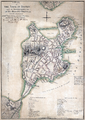 Map showing a British tactical evaluation of Boston in 1775. It shows a street called "Treamount Street" near School Street north of Common Street on the northeastern corner of the Boston Common
 -
 Tremont St., 1798
 -
 Faneuil mansion, c. 19th century
 -
 Tremont St., c. 1843, by Philip Harry
 -
 Gleason's Publishing Hall, corner of Tremont and Bromfield St., 1851
 -
 Advertisement for Chas. E. Brewster's Natural History Store, 1861
 -
 Horticultural Hall, 19th century, photo by John P. Soule
 -
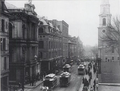 Tremont St., 1891
 -
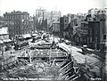 Intersection of Tremont St., Pleasant St., and Shawmut Ave., 1896


References
Notes
- ^ "MHC Reconnaissance Survey Town Report: Boston" (PDF). Massachusetts Historical Commission. January 1981. Retrieved 2009-08-23.
- ^ Page, Sir Thomas Hyde, "A plan of the town of Boston with the intrenchments &ca. of His Majesty's forces in 1775, from the observations of Lieut. Page of His Majesty's Corps of Engineers, and from those of other gentlemen." Source: Library of Congress
Further reading
- "Tremont Street". Gleasons Pictorial. 5. Boston, Mass. 1853.
- Views of Tremont Street, Boston. Bulletin of the Boston Public Library, 1894.
- City of Boston, Landmarks Commission. Connolly's Bar Study Report, 1997
External links
- "Tremont Street in the Rain, Boston, Massachusetts, undated". Historic New England. Photographer: Unknown
- http://www.loc.gov/pictures/item/2007661063
- http://www.loc.gov/pictures/item/2007661071
- Flickr. Photo of elevated railroad on Tremont St. at Granary, c. early 20th century. Includes view of Horticultural Hall. Courtesy of Bostonian Society.
Template:Boston Road Transportation
