Twante Township
Twante Township
တွံတေး မြို့နယ် Twantay Township | |
|---|---|
township | |
 | |
| Country | Burma (Myanmar) |
| Region | Yangon |
| Administrative seat | Twante |
| Population (2008)[1] | 202,221 |
| Time zone | UTC6:30 (MST) |
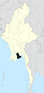
Twante Township also Twantay Township (Template:Lang-my, pronounced [tʊ̀ɴté mjo̰nɛ̀]) is a township in the Yangon Region of Burma (Myanmar). It is located west across the Hlaing River from the city of Yangon. The principal town and administrative seat is Twante. The township is home to the Shwesandaw Pagoda (known as "Golden Hair Relic Pagoda" in English) and it is believed to contain strands of hair from the head of Gautama, and its annual pagoda festival is held on Burmese New Year.[2] The longest man made canal in Myanmar is Twante canal and it is also a shortcut waterway to Ayawaddy river to Yangon river which divides Twante Township with its length of 35 km[3] and there is one bridge that spans the canal is called Twante bridge.[4] Baungdawgyoke Monastery in Twante Township is one the famous as there are pagodas including the replica of Mahabodhi Temple[5][6]

Communities
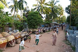
The 220 villages of Twante Township are organized into 65 village tracts and 8 urban wards.[1] Twante Township is well known for its pottery activities handled by a few families since several generations.[7] It is also area of fish farming in Yangon region.[8]
History
During the British rule in Burma, George Orwell was a police officer in Twante, responsible for the security of some 200,000 people.
Notes
- ^ a b "Profile Twantay Township" Myanmar Information Management Unit (MIMU), April 2009
- ^ Nyein Ei Ei Htwe (2010). "Twante rocks to Shan drum beat". Myanmar Times. Retrieved 5 March 2012.
- ^ "Twante Canal to open 24 hours".
- ^ "Twante Bridge Photo".
- ^ "News Report New Light of Myanmar,Visit of sinor general to Baungdawgyoke Monastery" (PDF).
- ^ "General Khin Nyunt visit Baungdawgyoke".
- ^ " Tourism Myanmar, June 2015
- ^ "In Twante, fish farmers yearn for cleaner water supplies".
External links
- "Twantay Township, Yangon Division" map ID: MIMU154 Twantay Township 090227 v01, February 2009, Myanmar Information Management Unit (MIMU)
- "Disaster Risk Reduction: Twantay Township" 5 July 2010, Myanmar Information Management Unit (MIMU), map showing Village Tracts
- "Twante Google Satellite Map" Maplandia World Gazetteer


