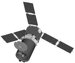
USA-231
 Illustration of the ORS-1 satellite | |
| Mission type | Imaging |
|---|---|
| Operator | US DoD |
| COSPAR ID | 2011-029A |
| SATCAT no. | 37728 |
| Spacecraft properties | |
| Bus | ATK satellite bus[clarification needed] |
| Manufacturer | Alliant Techsystems |
| Launch mass | 434 kilograms (957 lb)[1] |
| Start of mission | |
| Launch date | 1 July 2011, 03:09 UTC[2] |
| Rocket | Minotaur I |
| Launch site | Mid-Atlantic Regional Spaceport LP-0B |
| Contractor | Orbital Sciences |
| Orbital parameters | |
| Reference system | Geocentric |
| Regime | Low Earth |
| Perigee altitude | 423 kilometers (263 mi)[3] |
| Apogee altitude | 427 kilometers (265 mi)[3] |
| Inclination | 40.07 degrees[3] |
| Period | 92.93 minutes[3] |
| Epoch | January 13, 2015, 04:45:04 UTC[3] |
USA-231,[4] or ORS-1 (Operationally Responsive Space-1) is an American reconnaissance satellite which was launched in 2011 from NASA’s Wallops Flight Facility, Virginia by a Minotaur I launch vehicle.[2] It is the first operational satellite of the Operationally Responsive Space Office. It is equipped with a Senior Year Electro-Optical Reconnaissance System (SYERS) 2A.[5]
ORS-1 satellite is designed to provide orbital space imagery of Southwest Asia and to enhance battlespace awareness to operational field commanders. The ORS-1 will undergo a 30-day trial and adjustment check before the ORS Office turns over it operations to USAF’s 1st Space Operations Squadron at Schriever AFB, Colorado.[2]

SYERS functions
It has been suggested that this section be split out into another article titled Senior Year Electro-Optical Reconnaissance System. (Discuss) (March 2016) |
SYERS 2 is an optical and infrared camera with a 40 cm aperature and a field of view larger than 2 degree. It uses Time Delay and Integration CCD sensors to compensate for ground motion, resulting in a resolution of 1m (NIIRS 4) from a nominal 300 km orbit.[6] SYERS 2 is supplied by the Goodrich Corporation.
SYERS previous version has also been used with the Lockheed U-2 reconnaissance aircraft.[7]
See also
- 2011 in spaceflight
- NASA web page on ORS 1
- SYERS 2 Reconnaissance Sensor(Goodrich acquired by UTS Aerospace, link now broken - try ISR systems and [1])
References
- ^ "UCS Satellite Database". Union of Concerned Scientists. September 1, 2013. Retrieved December 25, 2013.
- ^ a b c Church, Aaron, Assoc. Editor (August 2011). "Air Force World – Minotaur on the Chesapeake". Air Force Magazine. Vol. 94, no. 8. Air Force Association. p. 17. ISSN 0730-6784. Retrieved August 4, 2011.
{{cite magazine}}:|first=has generic name (help); Cite has empty unknown parameter:|coauthors=(help)CS1 maint: multiple names: authors list (link). - ^ a b c d e Peat, Chris (January 13, 2015). "ORS 1 (USA 231) - Orbit". Heavens-Above. Retrieved January 25, 2015.
- ^ Christy, Robert. "2011". Zarya Diaries. Retrieved July 11, 2011.
- ^ Morring, Jr., Frank (June 27, 2011). "ORS-1 Satellite Set For Launch". Aviation Week.
- ^ Stanley Kishner, David Flynn, Charles Cox (2006). "E-O Reconnaissance Payloads for Responsive Space: Leveraging Airborne Sensor Investments" (PDF). AIAA 4th Responsive Space Conference 2006.
{{cite web}}: CS1 maint: multiple names: authors list (link) - ^ Voorhees, Carla (June 28, 2011). "ORS-1 Imaging Satellite Scheduled For Liftoff". dodlive.mil.
