Loučná pod Klínovcem
Loučná pod Klínovcem | |
|---|---|
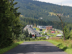
 Road to Loučná pod Klínovcem | |
| Coordinates: 50°24′46″N 12°59′23″E / 50.41278°N 12.98972°E | |
| Country | |
| Region | Ústí nad Labem |
| District | Chomutov |
| First mentioned | 1431 |
| Government | |
| • Mayor | Jana Nýdrová |
| Area | |
• Total | 20.89 km2 (8.07 sq mi) |
| Elevation | 865 m (2,838 ft) |
| Population (2024-01-01)[1] | |
• Total | 198 |
| • Density | 9.5/km2 (25/sq mi) |
| Time zone | UTC+1 (CET) |
| • Summer (DST) | UTC+2 (CEST) |
| Postal code | 431 91 |
| Website | www |
Loučná pod Klínovcem (until 1947 Český Wiesenthal; German: Böhmisch Wiesenthal) is a town in Chomutov District in the Ústí nad Labem Region of the Czech Republic. It has about 200 inhabitants, which makes it the second least populated town in the country.
Administrative parts
[edit]The town is made up of the town parts of Háj and Loučná.
Geography
[edit]Loučná pod Klínovcem is located about 30 kilometres (19 mi) west of Chomutov and 21 km (13 mi) north of Karlovy Vary. The town lies on the border with Germany, the German part of the divided town is called Oberwiesenthal. It lies in the Ore Mountains. The highest point of the municipal territory and of the entire Ústí nad Labem Region is a contour line below the top of the Klínovec Mountain at 1,231 m (4,039 ft) above sea level.
History
[edit]The first written mention of Loučná pod Klínovcem is from 1431, under its German name Wiesenthal. The village was probably founded in the 14th century. The village was destroyed during the Hussite Wars and was abandoned. At the beginning of the 16th century, mining developed in the area, Český Wiesenthal was resettled and its importance began to grow.[2]
In 1947, the town and the municipality were renamed from Český Wiesenthal to Loučná.[3]
Demographics
[edit]
|
|
| ||||||||||||||||||||||||||||||||||||||||||||||||||||||
| Source: Censuses[4][5] | ||||||||||||||||||||||||||||||||||||||||||||||||||||||||
Transport
[edit]On the Czech-German border is the road border crossing Loučná / Oberwiesenthal.
Sport
[edit]There is a large ski resort on the slopes of Klínovec.[6]
Sights
[edit]
There are not many monuments in the town. A technical monument is the former lime kiln. It is a Neo-Romanesque building from 1851. Production in it was ended in the 1920s.[7]
Notable people
[edit]- Hans Erich Slany (1926–2013), German industrial designer
References
[edit]- ^ "Population of Municipalities – 1 January 2024". Czech Statistical Office. 2024-05-17.
- ^ "Občan" (in Czech). Obec Loučná pod Klínovcem. Retrieved 2022-09-13.
- ^ "Vyhláška č. 7/1948 Sb". Zákony pro lidi (in Czech). Retrieved 2023-11-06.
- ^ "Historický lexikon obcí České republiky 1869–2011" (in Czech). Czech Statistical Office. 2015-12-21.
- ^ "Population Census 2021: Population by sex". Public Database. Czech Statistical Office. 2021-03-27.
- ^ "Ski map". Skiareál Klínovec. Retrieved 2022-09-13.
- ^ "Vápenka" (in Czech). National Heritage Institute. Retrieved 2023-11-06.


