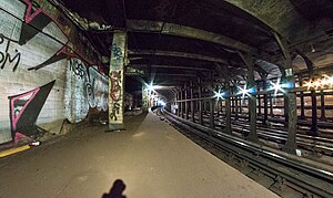
Worth Street station
Worth Street | |||
|---|---|---|---|
 Platform of the Worth Street station | |||
| Station statistics | |||
| Address | Lafayette Street & Worth Street New York, NY | ||
| Borough | Manhattan | ||
| Locale | Civic Center | ||
| Coordinates | 40°42′56″N 74°00′11″W / 40.7155°N 74.003°W | ||
| Division | [1] | ||
| Line | IRT Lexington Avenue Line | ||
| Services | None (abandoned) | ||
| Structure | Underground | ||
| Platforms | 2 side platforms | ||
| Tracks | 4 | ||
| Other information | |||
| Opened | October 27, 1904[2] | ||
| Closed | September 1, 1962[3] | ||
| Opposite- direction transfer | Yes | ||
| Traffic | |||
| 2023 | [4] | ||
| Rank | out of 423[4] | ||
| Station succession | |||
| Next north | Canal Street | ||
| Next south | Brooklyn Bridge – City Hall | ||
| |||
| |||
Worth Street was a local station on the IRT Lexington Avenue Line of the New York City Subway. It is located at Lafayette Street and Worth Street, and has four tracks and two side platforms.
History
Track layout | |||||||||||||||||||||||||||||||||||||||||||||||||||||||||||||||||||||||||||||||||||||||||||||||||||||||||||||||||||||||||||||||||||||||||||||||||||
|---|---|---|---|---|---|---|---|---|---|---|---|---|---|---|---|---|---|---|---|---|---|---|---|---|---|---|---|---|---|---|---|---|---|---|---|---|---|---|---|---|---|---|---|---|---|---|---|---|---|---|---|---|---|---|---|---|---|---|---|---|---|---|---|---|---|---|---|---|---|---|---|---|---|---|---|---|---|---|---|---|---|---|---|---|---|---|---|---|---|---|---|---|---|---|---|---|---|---|---|---|---|---|---|---|---|---|---|---|---|---|---|---|---|---|---|---|---|---|---|---|---|---|---|---|---|---|---|---|---|---|---|---|---|---|---|---|---|---|---|---|---|---|---|---|---|---|---|
| |||||||||||||||||||||||||||||||||||||||||||||||||||||||||||||||||||||||||||||||||||||||||||||||||||||||||||||||||||||||||||||||||||||||||||||||||||
Worth Street was one of the 28 original stations of the first subway line in Manhattan, opening on October 27, 1904.[5] At this time, Worth Street served local trains from the now-abandoned City Hall station to 145th Street at Broadway.
The station was lengthened twice. Like all the local stops, it was originally about 200 feet long to accommodate five-car trains. The first door of the first car and last door of the last car were left past the platform ends and were not opened. Because of overcrowding, the Public Service Commission ordered the local platforms extended a few yards into the "manholes" at the ends, that is, the space left for access to equipment closets. Completed in 1910, this gave just enough room for six-car local trains with only a door of the first and last cars at the platform. The second platform lengthening was done in 1948 by the Board of Transportation on the downtown side only that provided for the full length of a ten-car train (510 feet). The work was done on the downtown side to save costs. This side was chosen as it was the main unloading side in the business district.
On January 3, 1957, the New York City Transit Authority announced that this station would be closed within two years as part of a plan to improve the Brooklyn Bridge – City Hall station. As part of the project, the platforms at Brooklyn Bridge would be lengthened to accommodate ten-car trains, and the curved platform at Brooklyn Bridge would be eliminated. In order to achieve both of these goals, the platforms would be extended 250 to the north. The Worth Street station would be closed as it would only be 600 feet away from the platforms at Brooklyn Bridge. If the station were retained, service on the line would be slowed down, and no signal system could operate well in such a short distance. The project would cost $4,400,000 and was projected to take two years.[6] The station was closed on September 1, 1962 once the work at Brooklyn Bridge was completed.[3] After the Worth Street station's closure, Brooklyn Bridge – City Hall was named Brooklyn Bridge – Worth Street on platform signs until 1995.
Station layout
| G | - | Street level |
| P Platform level |
Side platform, not in service | |
| Northbound local | ← | |
| Northbound express | ← | |
| Southbound express | → | |
| Southbound local | → | |
| Side platform, not in service | ||
This station lies beneath the sidewalk on the west side of Foley Square. When the Federal Plaza Building was in the planning stages, it was found that, because of the existence of the station, the building could not extend out to Foley Square. As a result, the structure is set far back from the street, well beyond the station. The building's plaza and fountain lie directly above the station. The station's platforms are visible from the side windows of trains between Canal Street and Brooklyn Bridge – City Hall.
See also
References
- ^ "Glossary". Second Avenue Subway Supplemental Draft Environmental Impact Statement (SDEIS) (PDF). Vol. 1. Metropolitan Transportation Authority. March 4, 2003. pp. 1–2. Archived from the original (PDF) on February 26, 2021. Retrieved January 1, 2021.
- ^ "Our Subway Open, 150,000 Try It". The New York Times. October 28, 1904. p. 1. Retrieved 2010-05-30.
- ^ a b Grutzner, Charles (September 1, 1962). "New Platform for IRT Locals At Brooklyn Bridge to End Jams". The New York Times. p. 42. Retrieved 2010-05-30.
- ^ a b "Annual Subway Ridership (2018–2023)". Metropolitan Transportation Authority. 2023. Retrieved April 20, 2024.
- ^ Subway opening to-day with simple ceremony New York Times Retrieved August 30, 2008
- ^ "IRT WILL ABANDON WORTH ST. STATION; Decision Based on Planned Extension of the Brooklyn Bridge Stop by 250 Feet". Retrieved 2016-09-04.
External links
- nycsubway.org – IRT East Side Line: Worth Street
- Abandoned Stations — Worth Street
- Forgotten NY — Original 28 - NYC's First 28 Subway Stations


