Yodfat
Yodfat | |
|---|---|
 | |
| Country | Israel |
| Council | Misgav |
| Region | Galilee |
| Affiliation | Kibbutz Movement |
| Founded | 1960 |
| Founded by | Hebrew Reali School graduates |
| Website | www.romgalil.org.il |
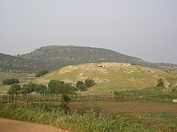
Yodfat (Template:Lang-he-n), is a moshav shitufi in the Lower Galilee, south of Carmiel, Israel.[1] Yodfat is part of the Misgav Regional Council. Located in the vicinity of the Atzmon mountain ridge, north of the Beit Netofa Valley, Yodfat is named after the Second Temple-era city of Yodfat. It is situated north of the archaeological mound.[2] Yodfat was established in 1960 by graduates of the Hebrew Reali School of Haifa.[1]
History
Antiquity

Yodfat (also Jotapata, Yodefat, Tel Yodfat, Iotapata, Jodeptah, Yotvah, Tell Jafat, Yotapatha, or Jotbah) was an ancient fortified Jewish village whose siege and subsequent destruction in 67 CE is described in Josephus Flavius' The Wars of the Jews, his chronicle of the Great Jewish Revolt against the Romans. The city was one of several Josephus fortified when he was assigned command of the Galilee. Its topographical position, situated on a hilltop flanked on three sides by steep ravines, meant it was only accessible from the north. It was on the north side, therefore, that the Roman army, led by Vespasian, camped when it arrived at Yodfat in the summer of 67. Leading three legions — Legio V Macedonica, X Fretensis, and XV Apollinaris plus supporting troops, for a total of about 60,000 men, Vespasian attempted an unsuccessful direct assault. Repulsed, Vespasian ordered his forces to besiege the city. The siege lasted 47 days, meeting strong resistance on the Jews' part (Vespasian himself was wounded), but eventually the city fell by treachery. Josephus describes the death of 40,000 Jews, while 1,000 women and children were sold into slavery. The city was razed and burnt on the first of the Hebrew month of Tammuz.[3] While the few dozen surviving fighters committed suicide, Josephus managed to survive this pact and was captured by the Romans .[4]
After the fall
After its capture by the Romans, Yodfat was repopulated by refugees from Jerusalem, among them the priestly family of Miyamin.[2] The city is mentioned in the Talmud as the home of Rabbi Menachem of Jotapata (Zev. 110b).[2] In 1847, the site was identified with Khirbet Jifat, some 10 miles north of Sepphoris.[2]
Archaeology
In 1999, archeological excavations revealed a mass grave containing human remains believed to be those of Jewish rebels who committed suicide rather than surrender to the Romans[5] Remains of fortifications and cisterns have also been found at the site.[2].
Economy
In 1968, Yodfat established a flower bulb nursery which exports millions of bulbs throughout the world. The nursery employs forty people and has an R&D facilities for developing new hybrids, among them Ornithogalum dubium and Cyclamen persicum. Yodfat's Jerusalem hybrid F1 anemones and Galilee hybrid F1 anemones are hand-pollinated and unique in the cut-flower trade.[6]
References
- ^ a b Mapa's concise gazetteer of Israel. Yuval El'azari (ed.). Tel-Aviv: Mapa Publishing. 2005. p. 216. ISBN 9657184347.
{{cite book}}: CS1 maint: others (link) Template:He icon - ^ a b c d e Encyclopedia Judaica, Joptapata, Keter Publishing, Jerusalem, 1978, volume 10, p. 300.
- ^ Gottheil, Richard. "Jotapata". Jewish Encyclopedia. Retrieved 2008-08-31.
{{cite encyclopedia}}: Unknown parameter|coauthors=ignored (|author=suggested) (help) - ^ "Yodfat". tourism.gov.il. Retrieved 2008-08-31.
- ^ Geva, Hillel (1999). "Recent Archeological Discoveries". Jewish Virtual Library. Retrieved 2008-08-31.
- ^ "Yodfat Agriculture Company Ltd". mamitop.org.il. Retrieved 2008-08-31.

