
Zürich Tiefenbrunnen railway station
Zürich Tiefenbrunnen | ||||||||||||||||
|---|---|---|---|---|---|---|---|---|---|---|---|---|---|---|---|---|
 Aerial view of the station looking west | ||||||||||||||||
| General information | ||||||||||||||||
| Location | Tiefenbrunnen, City of Zürich, Canton of Zürich, Switzerland | |||||||||||||||
| Coordinates | 47°21′00″N 8°33′41″E / 47.3501°N 8.5613°E | |||||||||||||||
| Owned by | Swiss Federal Railways | |||||||||||||||
| Operated by | Swiss Federal Railways | |||||||||||||||
| Line(s) | Lake Zürich right bank line | |||||||||||||||
| Platforms | 3 | |||||||||||||||
| Connections | Zürich trams (routes 2 and 4) Zürich trolleybuses (route 33) AZZK regional buses | |||||||||||||||
| Services | ||||||||||||||||
| ||||||||||||||||
Zürich Tiefenbrunnen railway station (German: Bahnhof Zürich Tiefenbrunnen) is a railway station in the Swiss city of Zürich. It is located on the Lake Zürich right bank railway line, and is situated on the shore of Lake Zürich, in the Seefeld quarter of the city.[1]
Operation
The station has one side platform and one island platform, served by three tracks, and the station building and entrance is on the west or lake side of the station. The platforms and entrances are connected by pedestrian subway.
The station is served by the following passenger trains:[2][3][4]
| Operator | Train Type | Route | Typical Frequency | Notes |
|---|---|---|---|---|
| Swiss Federal Railways | Zürich S-Bahn S6 |
Baden - Wettingen - Würenlos - Otelfingen - Otelfingen Golfpark - Buchs-Dällikon - Regensdorf-Watt - Zürich Affoltern - Zürich Seebach - Zürich Oerlikon - Zürich Hardbrücke - Zürich Hauptbahnhof - Zürich Stadelhofen - Zürich Tiefenbrunnen - Zollikon - Küsnacht Goldbach - Küsnacht ZH - Erlenbach ZH - Winkel am Zürichsee - Herrliberg-Feldmeilen - Meilen - Uetikon | 2 trains per hour | |
| Swiss Federal Railways | Zürich S-Bahn S16 |
Thayngen - Schaffhausen - Neuhausen - Andelfingen - Winterthur Hauptbahnhof - Effretikon - Zürich Airport - Zürich Oerlikon - Zürich Hardbrücke - Zürich Hauptbahnhof - Zürich Stadelhofen - Zürich Tiefenbrunnen - Zollikon - Küsnacht Goldbach - Küsnacht ZH - Erlenbach ZH - Winkel am Zürichsee - Herrliberg-Feldmeilen - Meilen | 2 trains per hour |
Adjacent to the station is the terminus of tram routes 2 and 4 and trolleybus route 33, all operated by Verkehrsbetriebe Zürich, the municipal transport operator for Zürich. The station is also served by regional bus routes of the Autobusbetrieb Zürich–Zollikon–Küsnacht (AZZK).[5][6][7]
The Zürichhorn lakeside park, with its Chinese Garden, Centre Le Corbusier, casino and steamer pier, lies some 700 metres (2,300 ft) north-west of the station. The steamer pier is served by boats of the Zürichsee-Schifffahrtsgesellschaft on both its Lake Zurich and River Limmat services.[1]
Gallery
-
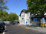 The station frontage
 -
 Interchange between train and tram


References
- ^ a b map.geo.admin.ch (Map). Swiss Confederation. Retrieved 2012-04-22.
- ^ "S-Bahn trains, buses and boats" (PDF). ZVV. Retrieved 2013-04-04.
- ^ "Baden–Regensdorf-Watt–Oerlikon–Zürich HB–Uetikon" (PDF). Bundesamt für Verkehr. Retrieved 2013-04-04.
- ^ "Thayngen–Schaffhausen–Flughafen ò–Zürich HB–Herrliberg-F" (PDF). Bundesamt für Verkehr. Retrieved 2013-04-18.
- ^ "City of Zurich network map" (PDF). ZVV. Retrieved 2011-09-09.
- ^ Eisenbahnatlas Schweiz. Verlag Schweers + Wall GmbH. 2012. pp. 64–65. ISBN 978-3-89494-130-7.
- ^ "AZZK Netzplan" (in German). Autobusbetrieb Zürich-Zollikon-Küsnacht. Retrieved 2013-09-05.
{{cite web}}: Unknown parameter|trans_title=ignored (|trans-title=suggested) (help)
External links
 Media related to Zürich Tiefenbrunnen railway station at Wikimedia Commons
- Passenger information on Zürich Tiefenbrunnen railway station from the SBB
This article about a railway station in Switzerland is a stub. You can help Wikipedia by expanding it. |