Šilheřovice
Šilheřovice | |
|---|---|
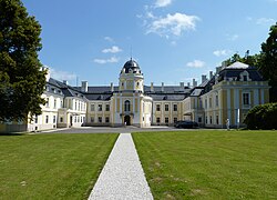
 Šilheřovice Castle | |
| Coordinates: 49°55′34″N 18°16′13″E / 49.92611°N 18.27028°E | |
| Country | |
| Region | Moravian-Silesian |
| District | Opava |
| First mentioned | 1377 |
| Area | |
| • Total | 21.65 km2 (8.36 sq mi) |
| Elevation | 221 m (725 ft) |
| Population (2024-01-01)[1] | |
| • Total | 1,592 |
| • Density | 74/km2 (190/sq mi) |
| Time zone | UTC+1 (CET) |
| • Summer (DST) | UTC+2 (CEST) |
| Postal code | 747 15 |
| Website | www |
Šilheřovice (German: Schillersdorf, Polish: Szylerzowice) is a municipality and village in Opava District in the Moravian-Silesian Region of the Czech Republic. It has about 1,600 inhabitants. It is part of the historic Hlučín Region.
Geography
[edit]Šilheřovice is located about 8 kilometres (5 mi) north of Ostrava, on the border with Poland. The western part of the municipality lies in the Opava Hilly Land and the eastern part lies in the Ostrava Basin. The highest point is at 286 m (938 ft) above sea level. The stream Šilheřovický potok flows through the municipality. The Oder River briefly flows along the eastern municipal border.
History
[edit]The first written mention of Šilheřovice is from 1377 deed, when it was part of the Silesian Duchy of Opava in the Lands of the Bohemian Crown. With the Hlučín Region it was annexed by Prussia after the First Silesian War in 1742.[2]
In 1787 the Prussian noble Friedrich von Eichendorff purchased the estates and had a Neoclassical castle built, where his young nephew Joseph von Eichendorff spent several vacations. In 1846 Šilheřovice Castle was acquired by Salomon Mayer von Rothschild, progenitor of the Rothschild banking family of Austria, while in 1920 the Hlučín Region was adjudicated to Czechoslovakia according to the terms of the Treaty of Versailles.[2]
Demographics
[edit]
|
|
| ||||||||||||||||||||||||||||||||||||||||||||||||||||||
| Source: Censuses[3][4] | ||||||||||||||||||||||||||||||||||||||||||||||||||||||||
Transport
[edit]There are no railways or major roads passing through the municipality.
Sport
[edit]There is a golf course in the castle park.[5]
Sights
[edit]
The most notable monument is Šilheřovice Castle, built in 1787–1815. It is surrounded by a large English-style park. Today the castle is privately owned and is partially accessible during the social events.[2][5]
The Church of the Assumption of the Virgin Mary was built in the Baroque style in 1713.[2]
Notable people
[edit]- Georg Gawliczek (1919–1999), German football player and coach
References
[edit]- ^ "Population of Municipalities – 1 January 2024". Czech Statistical Office. 2024-05-17.
- ^ a b c d "Historie" (in Czech). Obec Šilheřovice. Retrieved 2022-03-17.
- ^ "Historický lexikon obcí České republiky 1869–2011" (in Czech). Czech Statistical Office. 2015-12-21.
- ^ "Population Census 2021: Population by sex". Public Database. Czech Statistical Office. 2021-03-27.
- ^ a b "History of the castle". Šilheřovice Castle. Retrieved 2022-03-17.


