Berrian, Washington
Appearance
Berrian, Washington | |
|---|---|
| Coordinates: 45°56′15″N 119°09′07″W / 45.9376327°N 119.1519549°W[1] | |
| Country | United States |
| State | Washington |
| County | Benton |
| Elevation | 354 ft (108 m) |
| Time zone | UTC-8 (Pacific (PST)) |
| • Summer (DST) | UTC-7 (PDT) |
| ZIP code | 99337 |
| Area code | 509 |
| GNIS feature ID | 1510821[2] |
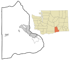
Berrian was an unincorporated community in Benton County, Washington, located approximately nine miles east of Umatilla, Oregon, on the north bank of the Columbia River.
The community was named after Augustus F. Berrian, who settled in the area in 1884. In February 1913, the community was officially platted by the Commercial Orchard Land Company. Berrian had a post office from April 25, 1913, to April 30, 1949.[4][5]
References
[edit]- ^ "Berrian". Geographic Names Information System. United States Geological Survey, United States Department of the Interior. Retrieved October 28, 2012.
- ^ a b "US Board on Geographic Names". United States Geological Survey. October 25, 2007. Retrieved January 31, 2008.
- ^ "U.S. Census website". United States Census Bureau. Retrieved January 31, 2008.
- ^ "Station Roster Master List: Berrian". Northern Pacific Railway Historical Association. Retrieved October 30, 2012.
- ^ "Washington Place Names database". Tacoma Public Library. Archived from the original on September 5, 2012. Retrieved October 30, 2012.


