
Garhakota
Garhakota | |
|---|---|
Town | |
 Garhakota Location in Madhya Pradesh, India  Garhakota Garhakota (India) | |
| Coordinates: 23°46′N 79°09′E / 23.77°N 79.15°E | |
| Country | |
| State | Madhya Pradesh |
| District | Sagar |
| Elevation | 373 m (1,224 ft) |
| Population (2011) | |
| • Total | 32,728 |
| Languages | |
| • Official | Hindi |
| Time zone | UTC+5:30 (IST) |
| Vehicle registration | MP-15 |
Garhakota is a town and a municipality in Sagar district in the state of Madhya Pradesh, India. It iss also a tehsil headquarter.
Geography[edit]
Garhakota is located at 23°46′N 79°09′E / 23.77°N 79.15°E.[1] It has an average elevation of 373 metres (1,223 feet). Garhakota is situated on the bank of Sunar River and Gadheri river.
Demographics[edit]
As of 2001[update] India census,[2] Garhakota had a population of 26,877. Males constitute 52% of the population and females 48%. Garhakota has an average literacy rate of 67%, higher than the national average of 59.5%: male literacy is 77%, and female literacy is 57%. In Garhakota, 16% of the population is under 6 years of age.
Many archaeological surveys have revealed that it has been a place of importance for many civilizations.
Government[edit]
Pt. Gopal Bhargava, who is currently the PWD Minister in MP government, comes from this town.
It comes under the Rehli constituency and is well developed in comparison to other towns of Sagar district.
Transportation[edit]
Garhakota is located on Sagar to Damoh and Katni road; daily bus service is available from here.
Tourism[edit]
- Shree 1008 Parshvanatha Digambar Jain Atishay Kshetra Pateriaji

This temple is more than 200 years old. It was built by Seth Radha Kishanjun Shah out of his one day earnings from the cotton trade in 1782 A.D. (V.S. 1839). The principal deity of Pateria is Lord Parsvanath (The 23rd Teerthankar). This idol is two metres in height in Padmasana posture built with back stone with three serpent hoods. The spire of this temple is 27 metres high surrounded by a thick wall.[3]
- Shri Dig. Jain Chaudhari Mandir
This temple was built in 1891(V.S. 1948), has an eighteen metre high spire. It consists 63 idols, moolnayak of this temple is an idol of Lord Parsvanath with its 1,000 serpent hoods.
Shri. Dig. Jain Mahaveer Jinalay
This newly built jain temple in town Garhakota is one of the best jain temple in whole Sagar district. This was built in year 2015. A world famous Panchkalyanak held in Garhakota after 250 years from 25-12-2015 to 30-12-2015 for this very famous Jain temple.
The mulnayak of this temple is well known by its name Lord Mahaveer the 24th and last tirthankar of this yug of Jainism.
With the blessings of Puja Gurudev shree Kanji Swami this temple have the best infrastructure in comparison with others in complete Sagar district.
The Shri Dig Jain Mahaveer Jinalay, located in the town of Garhakota, stands as a splendid testament to Jain architecture and spirituality. Erected in 2015, this temple has swiftly gained recognition as one of the most distinguished Jain temples in the entirety of Sagar district.
In December 2015, a momentous event marked the temple's inauguration: the world-renowned Panchkalyanak ceremony, a celebration of profound significance that hadn't taken place in Garhakota for 250 years. This monumental occasion further solidified the temple's status as a beacon of Jainism.
The Mulnayak, the principal deity enshrined within, is none other than Lord Mahaveer, the 24th and final Tirthankar of this era in Jainism. His presence here adds immeasurable spiritual resonance to the temple, drawing pilgrims and devotees from far and wide.
The grandeur of this temple owes much to the blessings of Puja Gurudev Shree Kanji Swami, whose spiritual guidance has led to the creation of an infrastructure that sets a benchmark for other temples throughout Sagar district. The Shri Dig Jain Mahaveer Jinalay is a place of solace, devotion, and architectural splendor, offering a profound spiritual experience to all who visit.
Garhakota Fort has the rivers Sunar and Gadhairi on its two sides. It covers 11 acres. This fort was the residence of the Rajput Kings of Garhakota. During the first freedom struggle of India in 1857, Rani of Jhansi Lakshmi Bai wrote a letter to Raja Mardan Singh Bahadur of Garhakota to prepare against the British troops and to stop them at Sagar. Mardan Singh and Gunthai Pateriya were killed in the battle. The fort was raided and demolished by Sir Hugh Rose in 1858 in the course of Ghadar.[4]
- Pateriya Fort and Jagannathji Temple
Another fort was situated behind the main fort which was the residence of Pateriyas. They were Zameendars of Pateriya Riyasat and close associates of the Rajput Kings of Garhakota. They were Jijhotiya Brahmins. Pateriya was not their original surname. That was their title or "upadhi" which was awarded by the Bundela King Jujhar Singh for their victorious participation in battles against the Moguls in the 17th century. Pateriya Fort, Gopalji Krishna temple, Jagannathji Pateriya Vishnu temple and Shiv temple were built in 16th century AD. The Pateriya fort was abandoned after the Ghadar rampage. Land records evidence are available at the Revenue Office of Rehli tehsil; 1874 acres in name of Munna Lal Patriya of Garhakota, after independence in 1947.
-
 Pateriaji main vedi
 -
 Pateriaji Garbha Griha Bhattarka Mahendrakirti
 -
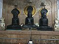
 Garhakota Chaudary mandir main vedi


See also[edit]
References[edit]
- ^ Falling Rain Genomics, Inc - Garhakota
- ^ "Census of India 2001: Data from the 2001 Census, including cities, villages and towns (Provisional)". Census Commission of India. Archived from the original on 16 June 2004. Retrieved 1 November 2008.
- ^ http://jain.org.in/tirth-Pateria%20M.%20P.html
- ^ The Revolt in Central India 1857-59 By Reginald George Burton, India. Army. Intelligence Branch, Government Monotype Press, 1908 p. 98