
Goderich Airport
Goderich Airport Goderich Municipal Airport | |||||||||||||||||||
|---|---|---|---|---|---|---|---|---|---|---|---|---|---|---|---|---|---|---|---|
| Summary | |||||||||||||||||||
| Airport type | Public | ||||||||||||||||||
| Operator | Municipality of Goderich | ||||||||||||||||||
| Location | Goderich, Ontario | ||||||||||||||||||
| Time zone | EST (UTC−05:00) | ||||||||||||||||||
| • Summer (DST) | EDT (UTC−04:00) | ||||||||||||||||||
| Elevation AMSL | 709 ft / 216 m | ||||||||||||||||||
| Website | www.goderich.ca/.../airport.asp | ||||||||||||||||||
| Map | |||||||||||||||||||
 CYGD Location in Ontario | |||||||||||||||||||
| Runways | |||||||||||||||||||
| |||||||||||||||||||
Goderich Airport (ICAO: CYGD), also known as Goderich Municipal Airport, is a registered aerodrome located 1.5 nautical miles (2.8 km; 1.7 mi) north of Goderich, Ontario, Canada. The aerodrome is best known as the home of Sky Harbour Aircraft, an aircraft paint shop.

The airport is classified as an airport of entry by NAV CANADA and is staffed by the Canada Border Services Agency. CBSA officers at this airport currently can handle general aviation aircraft only, with no more than 15 passengers.[1]
History
During World War II, Goderich Airport hosted No. 12 Elementary Flying School for the British Commonwealth Air Training Plan, providing initial pilot training for aircrews using the Fleet Finch.
-
 BCATP Summary Plaque
 -
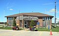 Sky Harbour Terminal - Goderich Airport
 -
 BCATP Lancaster Cairn


References
- ^ a b Canada Flight Supplement. Effective 0901Z 16 July 2020 to 0901Z 10 September 2020.
- ^ Synoptic/Metstat Station Information
External links
- Goderich Municipal Airport (official site)
- Goderich Municipal / Skyharbour Airport on COPA's Places to Fly airport directory
| By name | |
|---|---|
| By location indicator | |
| By province/territory | |
| By area | |
| National Airports System | |
| Related | |