King's Highway (ancient)
This article needs additional citations for verification. (August 2014) |
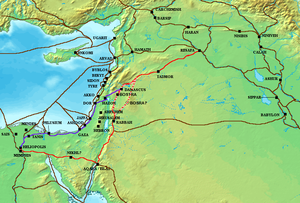
The King’s Highway was a trade route of vital importance to the ancient Near East. It began in Egypt, and stretched across the Sinai Peninsula to Aqaba. From there it turned northward across Transjordan, leading to Damascus and the Euphrates River.
Route

The Highway began in Heliopolis, Egypt and from there went eastward to Clysma (modern Suez), through the Mitla Pass and the Egyptian forts of Nekhl and Themed in the Sinai desert to Eilat and Aqaba. From there the Highway turned northward through the Arabah, past Petra and Ma'an to Udruh, Sela, and Shaubak. It passed through Kerak and the land of Moab to Madaba, Rabbah Ammon/Philadelphia (modern Amman), Gerasa, Bosra, Damascus, and Tadmor, ending at Resafa on the upper Euphrates.
History
Numerous ancient states, including Edom, Moab, Ammon, and various Aramaean polities depended largely on the King's Highway for trade.
The Nabataeans used this road as a trade route for luxury goods such as frankincense and spices from southern Arabia. It was possibly the cause of their war with Hasmonean Alexander Jannaeus and with Iturea in the beginning of the 1st century BC.[1]
During the Roman Empire period, the King's Highway was rebuilt by Trajan and called the Via Traiana Nova.
The Highway has also been used as an important pilgrimage route for Christians, as it passed numerous sites important in Christianity, including Mount Nebo and al-Maghtas ("the Baptism Site") at the Jordan River, where Jesus is believed to have been baptized by John the Baptist. Muslims used it as the main Hajj route from Syria to Mecca, until the Ottoman Turks built the Tariq al-Bint in the 16th century, except in the Crusader period, when the road passed through Oultrejordain.[2]
In the Bible
The Highway is referred to in the Hebrew Bible Book of Numbers, (Numbers 20:17, 21:22), where it is related that the Israelites, in their Exodus, requested a right of way across Edom but were refused. After making a detour and coming to Transjordan, they directed the same request to Sihon the Emorite, but had to fight him to pass in the road section he ruled - between Arnon and Zarqa Rivers. As a result they gained contorl in that land.
Many of the wars of the Israelites against the kingdoms of the trans-Jordanian highlands during the period of the Kingdom of Israel (and its sister-kingdom, the Kingdom of Judah) probably were at least partly over control of the Highway.
See also
References
- ^ Kasher, Aryeh (1985-01-01). "Alexander Yannai's Wars with the Nabataeans / מלחמות אלכסנדר ינאי בנבטים". Zion / ציון (in Hebrew). 50: 107–120. ISSN 0044-4758. JSTOR 23559931. Retrieved 2014-08-15; English abstract: JSTOR 23559946, p. XI.
- ^ Petersen, Andrew (2013). "The Lost Fort of Mafraq and the Syrian Hajj Route in the 16th Century". In Porter, Venetia; Saif, Liana (eds.). The Hajj: collected essays. p. 21. ISBN 9780861591930.
