
Kita-ku, Nagoya
Kita
北区 | |
|---|---|
| Kita Ward | |
  Meijō Park Ōzone | |
 Location of Kita-ku in Nagoya | |
 Kita | |
| Coordinates: 35°11′39″N 136°54′42″E / 35.19417°N 136.91167°E | |
| Country | Japan |
| Region | Chūbu region Tōkai region |
| Prefecture | Aichi |
| Area | |
| • Total | 17.53 km2 (6.77 sq mi) |
| Population (October 1, 2019) | |
| • Total | 163,555 |
| • Density | 9,300/km2 (24,000/sq mi) |
| Time zone | UTC+9 (Japan Standard Time) |
| - Tree | Sakura |
| - Flower | Cosmos (flower)[1] |
| Phone number | 052-911-3131 |
| Address | 17-1, Shimizu 4-chome, Kita-ku, Nagoya-shi, Aichi-ken 462-8511 |
| Website | www |
Kita Ward (北区, Kita-ku) is one of the 16 wards of the city of Nagoya in Aichi Prefecture, Japan. As of 1 October 2019, the ward had an estimated population of 163,555 and a population density of 9,330 persons per km2. The total area was 17.53 km2.

Geography[edit]
Kita Ward is the north of the center of the city of Nagoya.
Surrounding municipalities[edit]
History[edit]
Kita Ward was founded in 1944. Its area was expanded in 1946 with an addition from Higashi-ku and again in 1951 with an addition from Naka-ku. In 1955, the village of Kusunoki, formerly part of Nishikasugai District was annexed by Nagoya city, and joined to Kita Ward.

Economy[edit]
Kita Ward is largely a regional commercial center and bedroom community for central Nagoya.
- Ōzone Sub CBD
- Mets Ōzone (Higashi-ku)
- Mitsubishi Electric Corporation Nagoya Factory (Higashi-ku)
- OZ Garden
- OZ Mall
-
 Ōzone
Ōzone -
 Marion Ōzone
 -
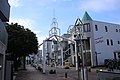 OZ Mall
 -
 OZ Garden
 -
 Ōzone Station Intersection


Education[edit]
University[edit]
- Aichi Gakuin University
- Nagoya Sangyo University Satellite campus
- Nagoya Zokei University
-

-
 Nagoya Sangyo University Satellite campus
 -


Transportation[edit]


Railroads[edit]
- Meitetsu - Meitetsu Seto Line
- Meitetsu - Meitetsu Komaki Line
- Nagoya Municipal Subway – Meijō Line
- Nagoya Municipal Subway – Kamiiida Line
Highways[edit]
Local attractions[edit]

- Meijō Park
- Tonarino
- Nagoya Airfield
- Ozmall
-

-
 Tonarino
 -
 Ozmall


Wikimedia Commons has media related to Kita-ku, Nagoya.
References[edit]
| Nagoya |
| |||
|---|---|---|---|---|
| Core cities | ||||
| Special city | ||||
| Cities | ||||
| Districts | ||||
| Former Districts | ||||
| International | |
|---|---|
| National | |
| Geographic | |