
Ninth Avenue station
Ninth Avenue | |||||||
|---|---|---|---|---|---|---|---|
 Platforms | |||||||
| Station statistics | |||||||
| Address | Ninth Avenue & 39th Street Brooklyn, NY 11232 | ||||||
| Borough | Brooklyn | ||||||
| Locale | Sunset Park | ||||||
| Coordinates | 40°38′48″N 73°59′41″W / 40.646575°N 73.994674°W | ||||||
| Division | B (BMT)[1] | ||||||
| Line | BMT West End Line BMT Culver Line (formerly) | ||||||
| Services | D | ||||||
| Transit | |||||||
| Structure | Open-cut | ||||||
| Levels | 2 (upper level is in revenue service) | ||||||
| Platforms | 4 island platforms (2 on each level) cross-platform interchange | ||||||
| Tracks | 6 (3 on each level) | ||||||
| Other information | |||||||
| Opened | June 24, 1916 | ||||||
| Closed | BMT Culver Line platforms: May 11, 1975 | ||||||
| Opposite- direction transfer | Yes | ||||||
| Traffic | |||||||
| 2023 | 1,263,578[2] | ||||||
| Rank | 244 out of 423[2] | ||||||
| Station succession | |||||||
| Next north | Template:NYCS next 36th Street (Fifth Avenue el; demolished) | ||||||
| Next south | Template:NYCS next Template:NYCS next Fort Hamilton Parkway (Culver Line; demolished) | ||||||
| |||||||
| |||||||
| |||||||
9th Avenue Station (Dual System BRT) | |||||||
| MPS | New York City Subway System MPS | ||||||
| NRHP reference No. | 05000676[3] | ||||||
| Added to NRHP | March 3, 2005 | ||||||


Ninth Avenue is a bi-level express station on the BMT West End Line of the New York City Subway, located at the intersection of Ninth Avenue and 39th Street in Brooklyn. Each level has three tracks and two island platforms. The upper level serves the BMT West End Line while the lower level formerly served the BMT Culver Line. Only the upper level is still in service and is served by the D train at all times. The center express track is not normally used.
Station layout
| 3F | Northbound local | ← |
| Peak-direction express | → No regular service (No service: 36th Street northbound or 62nd Street southbound) | |
| Southbound local | → | |
| 2F | Former northbound local | → Trackbed |
| Island platform, not in service | ||
| Former peak-direction express | → No regular service | |
| Island platform, not in service | ||
| Former southbound local | → Trackbed | |
| 1F | Mezzanine | to entrances/exits, station agent, MetroCard vending machines |
| G | Street Level | Entrances/Exits |
| style="color:white;background:#Template:NYCS color;text-align:center;padding:5px"| Track layout | ||||||||||||||||||||||||||||||||||||||||||||||||||||||||||||||||||||||||||||||||||||||||||||||||||||||||||||||||||||||||||||||||||||||||||||||||||||||||||||||||||||||||||||||||||||||||||||||||||||||||||||||||||||||||||||||||||||||||||||||||||||||||||||||||||||||||||||||||||||||||||||||||||||||||
|---|---|---|---|---|---|---|---|---|---|---|---|---|---|---|---|---|---|---|---|---|---|---|---|---|---|---|---|---|---|---|---|---|---|---|---|---|---|---|---|---|---|---|---|---|---|---|---|---|---|---|---|---|---|---|---|---|---|---|---|---|---|---|---|---|---|---|---|---|---|---|---|---|---|---|---|---|---|---|---|---|---|---|---|---|---|---|---|---|---|---|---|---|---|---|---|---|---|---|---|---|---|---|---|---|---|---|---|---|---|---|---|---|---|---|---|---|---|---|---|---|---|---|---|---|---|---|---|---|---|---|---|---|---|---|---|---|---|---|---|---|---|---|---|---|---|---|---|---|---|---|---|---|---|---|---|---|---|---|---|---|---|---|---|---|---|---|---|---|---|---|---|---|---|---|---|---|---|---|---|---|---|---|---|---|---|---|---|---|---|---|---|---|---|---|---|---|---|---|---|---|---|---|---|---|---|---|---|---|---|---|---|---|---|---|---|---|---|---|---|---|---|---|---|---|---|---|---|---|---|---|---|---|---|---|---|---|---|---|---|---|---|---|---|---|---|---|---|---|---|---|---|---|---|---|---|---|---|---|---|---|---|---|---|---|---|---|---|---|---|---|---|---|---|---|---|---|---|---|---|---|---|---|---|---|---|---|---|---|---|---|---|---|---|---|---|---|
| ||||||||||||||||||||||||||||||||||||||||||||||||||||||||||||||||||||||||||||||||||||||||||||||||||||||||||||||||||||||||||||||||||||||||||||||||||||||||||||||||||||||||||||||||||||||||||||||||||||||||||||||||||||||||||||||||||||||||||||||||||||||||||||||||||||||||||||||||||||||||||||||||||||||||
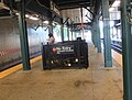
This ground-level station opened on June 24, 1916.[5][6] Both levels of the station have three tracks and two island platforms.
Upper level
The upper level is the only one in use. Only the local tracks are in regular service. On the upper level, the Manhattan-bound platform is slightly wider than the Coney Island-bound platform. Towards the west end of the upper level platforms is an employee-only pedestrian bridge that leads to the entrance of the 36th–38th Street Yard via a high turnstile. A control tower for line at the south end of the yard.[7]
As of 2012, the station has been renovated with new platform edges, a new dispatcher room and a new stairway that leads to the 36th Street Yard.
Lower level
The lower level was used as a through route for the BMT Culver Line to the BMT Fourth Avenue subway and the BMT Fifth Avenue elevated lines until 1954, when service on the main portion of the BMT Culver Line route was recaptured by the Independent Subway System via the Culver Ramp. A Culver Shuttle service from this station to a new single track terminal at Ditmas Avenue was begun at the same time. Some Culver trains continued to operate into Manhattan until May 1959. Culver Shuttle service was discontinued on May 11, 1975.
The lower level was abandoned afterwards and has not been used since except for filming of the original Crocodile Dundee movie when it posed as the 59th Street – Columbus Circle station at the end of the movie. However, the "9" wall mosaics and the sunlight seen at the very end of the film made it clear it was Ninth Avenue. The level is dark and there are no safety plates on the two staircases to that level. A fluorescent light remains on the southbound side. The next stop for this shuttle to the south (east) was Fort Hamilton Parkway. The tracks curve just east of the station before the center and southbound local end at bumper blocks, at the east end of the tunnel portal. The northbound local continues past the portal and runs along another track coming from the 36th–38th Street Yard, but does not connect with it. This track was the track used during Ninth Avenue – Ditmas Avenue shuttle operation from 1959 until 1975.
Exits
The station house is at street level near the intersection of 9th Avenue and New Utrecht Avenue, and there is a sealed entrance on the west side. The tablet grilles in the mezzanine are still intact and a newsstand once stood opposite the current location of the station agent booth.[8]
Track layout
As the West End line rises from embankment to elevated east of this station, the BMT Culver right-of-way can be seen leaving the tunnel on the Manhattan-bound side. Only one track leaves the tunnel, dead-ending approximately 750 feet later before Fort Hamilton Parkway with no further connections. There is also a platform present. The platform was installed in the late 1980s for New York City Transit employees only and is not part of the right-of-way.
To the west of the station is a complicated track layout complete with track connections from the Fourth Avenue Line, ramps from the now-demolished Fifth Avenue El, and ramps from the 36th–38th Street Yard, combining together to form the six tracks and two levels of the station.[9]
Beyond the ramps, as the line curves under the BMT Fourth Avenue Line, there are tracks that continue straight into the piers on the waterfront, which were once operated by the South Brooklyn Railway.[9] In the tunnel approaching 36th Street station, there is an unused trackway that was supposed to connect to the South Brooklyn Railway. The tunnel connection was never built. This trackway merges to the southbound track and runs for a long distance before ending at a wall.
Gallery
-
 Station house
 -
 Coney Island bound platform
 -
 Manhattan bound platform
 -
 The express track
 -
 Staircase to the lower level
 -
 Detail of decorative gate by Christopher Russell


.JPG)


References
- ^ "Glossary". Second Avenue Subway Supplemental Draft Environmental Impact Statement (SDEIS) (PDF). Vol. 1. Metropolitan Transportation Authority. March 4, 2003. pp. 1–2. Archived from the original (PDF) on February 26, 2021. Retrieved January 1, 2021.
- ^ a b "Annual Subway Ridership (2018–2023)". Metropolitan Transportation Authority. 2023. Retrieved April 20, 2024.
- ^ "NPS Focus". National Register of Historic Places. National Park Service. Retrieved December 9, 2011.
- ^ "Annual Subway Ridership (2018–2023)". Metropolitan Transportation Authority. 2023. Retrieved April 20, 2024.
- ^ "Realty Boom Is Predicted for Borough Park Section". Brooklyn Daily Eagle. June 24, 1916. Retrieved 16 September 2015.
- ^ "Parade, Pageant Mark Celebration: Borough Park Civic Bodies and School Children Join in Festivities: West End Line Opened: First Train From Manhattan Over New "L" Extension of Dual System to Sixty-Second Street". Brooklyn Daily Eagle. June 24, 1916. Retrieved 16 September 2015.
- ^ McKinley, James C., Jr. (August 16, 1994). "Subway Car Derails in Brooklyn, Injuring 11 Passengers". The New York Times. Retrieved 25 September 2015.
{{cite web}}: CS1 maint: multiple names: authors list (link) - ^ "MTA Neighborhood Maps: Sunset Park" (PDF). mta.info. Metropolitan Transportation Authority. 2015. Retrieved 2 August 2015.
- ^ a b "INVENTORY OF DECKING OPPORTUNITIES OVER TRANSPORTATION PROPERTIES Final Report: 6.7: TRANSIT AND RAILROAD YARDS: BROOKLYN" (PDF). nyc.gov. New York City Department of City Planning. September 2008. Retrieved 6 August 2015.
External links
- nycsubway.org – BMT West End Line: Ninth Avenue
- nycsubway.org – BMT Culver Line: Ninth Avenue
- Station Reporter — D Train
- The Subway Nut — Ninth Avenue Pictures
- Detail of area tracks
- Ninth Avenue entrance from Google Maps Street View
- Platforms from Google Maps Street View
| West End Line | |
|---|---|
| |

- BMT West End Line stations
- Defunct BMT Culver Line stations
- Railway and subway stations on the National Register of Historic Places in New York City
- New York City Subway stations in Brooklyn
- New York City Subway stations located aboveground
- Railway stations opened in 1916
- 1916 establishments in New York (state)
- Sunset Park, Brooklyn
- National Register of Historic Places in Brooklyn