
Outline of West Bengal
The following outline is provided as an overview of and topical guide to West Bengal.
West Bengal – 14th biggest, 4th most populous, 2nd in highest population density of the 29 states of the democratic Republic of India.[1] It is also the seventh-most populous sub-national entity in the world, with over 91 million inhabitants.[1] Covering a total area of 34,267 sq mi (88,750 km2), it is bordered by the countries of Nepal, Bhutan, and Bangladesh, and the Indian states of Orissa, Jharkhand, Bihar, Sikkim, and Assam. The state capital is Kolkata (formerly Calcutta). West Bengal encompasses two broad natural regions: the Gangetic Plain in the south and the sub-Himalayan and Himalayan area in the north.
General reference
- Names
- Common name: West Bengal
- Local name: Paschim Bongo
- Pronunciation:
- Official name: ?
- Abbreviations and name codes
- Nicknames
- Adjectivals
- Symbols
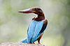
- Bird: white-throated kingfisher
- Animal: fishing cat
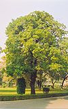
- Tree: devil tree
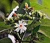
- Flower: night-flowering jasmine
- Union Day: August 18 ( Day of accession to India )
- Bird: white-throated kingfisher
- Outline of India

_3.jpg)


Geography
- West Bengal is: an Indian state, a state of the Republic of India.
- Location:
- Time zone: Indian Standard Time (UTC+05:30)
Places adjacent to Outline of West Bengal | ||||||||||||||||
|---|---|---|---|---|---|---|---|---|---|---|---|---|---|---|---|---|
| ||||||||||||||||
Administrative Districts and Divisions
Districts
- Alipurduar district
- Bankura

Districts of West Bengal - Bardhaman
- Birbhum
- Cooch Behar
- Darjeeling
- East Midnapore
- Hooghly
- Howrah
- Jalpaiguri
- Kolkata
- Malda
- Murshidabad
- Nadia
- North 24 Parganas Largest in terms of population and population density
- Uttar Dinajpur
- Purulia
- South 24 Parganas Largest in terms of area
- Dakshin Dinajpur
- West Midnapore

Divisions

A group of districts forms a division, which is administered by a 'Divisional Commissioner'. West Bengal is now divided in Twenty[2] districts, grouped under three divisions:[3]
| Jalpaiguri division | Burdwan division | Presidency division |
|---|---|---|
|
|
|
Notes
- ^ a b "India: Administrative Divisions (population and area)". Census of India. Archived from the original on December 17, 2012. Retrieved April 17, 2009.
- ^ http://www.business-standard.com/article/news-ians/alipurduar-becomes-bengal-s-20th-district-114062500725_1.html
- ^ "Directory of District, Sub division, Panchayat Samiti/ Block and Gram Panchayats in West Bengal, March 2008". West Bengal. National Informatics Centre, India. 2008-03-19. Retrieved 2008-11-19.