
Provinces of Ireland
This article needs additional citations for verification. (February 2014) |
| Provinces of Ireland Cúigí na hÉireann | |
| Location | |
 | |
Leinster Munster Connacht Ulster
| |
| Statistics | |
| Area: | 84,421 km² |
|---|---|
| Population (2011): | 6,241,700 |
Ireland has historically been divided into four provinces: Connacht, Leinster, Munster and Ulster. The Irish word for this territorial division, cúige, literally meaning "fifth part", indicates that there were once five; the fifth province, Meath, was incorporated into Leinster, with parts going to Ulster. The provinces of Ireland serve no administrative or political purposes, but function as historical and cultural entities.
Etymology
In modern Irish the word for province is cúige (pl. cúigeadh). The modern Irish term derives from the Old Irish cóiced (pl. cóiceda) which literally meant "a fifth".[1] This term appears in 8th century law texts such as Miadslechta and in the legendary tales of the Ulster Cycle where it refers to the five kingdoms of the "Pentarchy".[1] In the 12th-century Lebor na Cert (Book of Rights), the term means province, seemingly having lost its fractional meaning with seven cúigeadh listed.[1] Similarly this seems to be the case in regards to titles with the Annals of Ulster using the term rex in Chóicid (king of the fifth/province) for certain overkings.[1]
History

The origins of the provinces of Ireland can be traced to the medieval cóiceda (literally "fifths") or "over-kingdoms" of Ireland. There were theoretically five such over-kingdoms, however in reality during the historical period there where always more.[2][3] At the start of the 9th-century the following are listed: Airgíalla, Connachta, Laigin, Northern Uí Néill (Ailech), Southern Uí Néill (Mide), Mumu, and Ulaid.[2][3] These seven over-kingdoms are again listed in the 12th-century Lebor na Cert.[1]
Structure
Each over-kingdom was divided into smaller territorial units, the definition of which, whilst not consistent in Irish law tracts, followed a pattern of different grades.[2] In theory in the early medieval period:
- A province was ruled by a "king of over-kings", known as a rí ruírech. This was the highest rank allowed for in Irish law tracts despite claims by some dynasties to the symbolic title of rí Temro (king of Tara), also known as the ard rí (High King of Ireland);[1][2] The term rí ruírech was replaced at a later date by the term rí cóicid, "king of a fifth".[1]
- Each province was made up of several petty-kingdoms that corresponded roughly to the size of modern Irish counties or dioceses, and were ruled by an overking known as a ruirí;[2]
- Each of these petty-kingdoms were further subdivided into smaller petty-kingdoms known as a túath (a group of people), equating at their largest to the size of an Irish barony.[2] These túath where ruled by a king, or rí, and were also known as a rí túaithe, or "king of the people".[2] By the 10th-century the rulers of a túath were no longer assumed to be kings but became referred to as tigern (a lord) or toísech (a leader) instead.[2]
This pyramid structure however by the later medieval period had little validity.[2]
Paul MacCotter proposes the following structure of lordship in the 12th-century: High-king of Ireland; semi-provincial king, such as Connacht, Ulaid, Desmumu; regional king, such as Dál Fiatach and Uí Fhiachrach Aidni; local king or king of a trícha cét, such as Leth Cathail or Cenél Guaire; and taísig túaithe at the bottom.[4]
Later medieval period
Airgíalla had come under the dominance of the Ulaid,[5] however Niall Caille, the son of Áed Oirdnide, brought it under the hegemony of the Northern Uí Néill after defeating the combined forces of the Airgíalla and Ulaid at the battle of Leth Cam in 827.[6][7][8][9]
In the years following the Norman invasion of Ireland in 1169, the over-kingdoms of Connacht, Laigin, Mide, Mumu, and Ulaid formed the basis for the Norman liberties of Connacht, Leinster, Meath, Munster and Ulster respectively.[10] These liberties were later subdivided into smaller ones that became the basis for the counties of Ireland.[10] The Northern Uí Néill remained outside of Norman control, eventually absorbing the greater part of Airgialla, which had by the end of the 12th-century lost its eastern territory (afterwards known as "English Oriel" and later as Louth) to the Normans.[8] Airgíalla would eventually no longer be reckoned an over-kingdom however it survived in present-day County Monaghan for as long as the Gaelic order survived,[11] with the last king of Airgíalla being Hugh Roe McMahon, who reigned from 1589 until his execution in September/October 1590.
With the collapse of English control in Ireland following the Bruce campaign in Ireland in 1315, and the subsequent collapse of the Earldom of Ulster, the Gaelic order had a resurgence and the Clandeboye O'Neills of the Northern Uí Néill stepped into the power vacuum in Ulster bringing it under the sovereignty of the O'Neills of Tyrone. After this they claimed for the first time the title of rí Ulad, "king of Ulster", amalgamating their territory into one united province. This reduced the number of provinces to five—Connact, Leinster, Meath, Munster, and Ulster.
Tudor period
During the reign of Mary I (1553-1558), the Lord Deputy of Ireland, Thomas Radclyffe, 3rd Earl of Sussex, sought to divide Ireland into six parts—Connaught, Leinster, Meath, Nether Munster, Ulster, and Upper Munster.[10] His administrative reign in Ireland however was cut short and even with his reappointment by Elizabeth I (1568-1603) this plan was never implemented.[10]
Sir Henry Sidney during his three tenures as Lord Deputy created two presidencies headed by a Lord President to administer Connaught and Munster.[10] In an attempt to reduce the importance of the province of Munster, Sydney, using the River Shannon as a natural boundary took the former kingdom of Thomond (North Munster) and made it into the county of Clare as part of the presidency of Connaught in 1569.[10] Around 1600 near the end of Elizabeth's reign, Clare was made an entirely distinct presidency of its own under the Earls of Thomond and would not return to being part of Munster until after the Restoration in 1660.[10]
The exact boundaries of the provinces of Ireland during the Tudor period changed several times, usually as a result of the creation of new counties:
- County Clare upon its creation in 1569 was transferred from Munster to Connacht, and was only restored to Munster after 1660.[10]
- County Longford upon its creation in 1583 was transferred from Leinster to Connacht.[10][12]
- County Cavan was created in 1584 and transferred from Connacht to Ulster.[13]
- County Louth, which had long being part of The Pale, was transferred from Ulster to Leinster.[10]
It would not be until the reign of Elizabeth's successor, James I, that Meath by 1610 would cease to be considered a province and that the provincial borders would be permanently set.[10]
Prehistory
The earliest recorded mention of the major division of Ireland is in the Ulster Cycle of legends, such as the Táin Bó Cúailnge.[14][15] The Táin is set during the reign of Conchobar Mac Nessa, king of Ulster, and is believed to have happened in the 1st century.[16] In this period Ireland is said to have been divided into five independent over-kingdoms, or cuigeadh whose rí (kings) were of equal rank, not subject to a central monarchy.[14][1][16][17] Pseudo-historians called this era Aimser na Coicedach, which has been translated as: "Time of the Pentarchs";[14] "Time of the Five Fifths";[16] and "Time of the provincial kings".[17] It was also described as "the Pentarchy".[14][15]
The five provinces that made up the Pentarchy where:[14][15][16]
- Connacht, with its royal seat at Cruachain.
- Ulaid (Ulster), with its royal seat at Emain Macha.
- Muman (Munster), with its royal seat at Teamhair Erann.
- Laigen Tuathgabair (North Leinster), with its royal seat at Tara (before it became the seat of the High King).
- Laigen Desgabair (South Leinster), with its royal seat at Dinn Riogh.
Historians Geoffrey Keating and T. F. O'Rahilly differ suggesting that it is Munster, not Leinster, that formed two of the fifths.[17][18] These two fifths were called by Keating: Cuigeadh Eochaidh (eastern Munster) and Cuigeadh Con Raoi (western Munster),[18] both named after their respective king. Eoin MacNeill discounts this suggestion citing the Táin Bó Cúailnge, which makes mention of Eochaidh as king of all Munster, with Cu Roi simply a "great Munster hero".[14] He also cites that the Táin makes mention of the four fifths of Ireland that waged war on Ulster, which made reference to only one Munster.[14] Another reason given by MacNeill was a problem made by Keating himself. According to Keating, when the province of Míde was being founded, it was created from portions of each province which all met at the hill of Uisnech. The boundaries given by Keating himself for the five provinces however meant that this would have been highly unlikely, with the boundary between his Munster fifths nowhere near this area.[14]
Pseudo-historians list 84 kings of Ireland prior to the formation of the Pentarchy. When this mythical kingship was interrupted is a matter of dispute. The Annals of Tigernach state that Ireland was divided into the five upon the slaying of Conaire Mór, however it is suggested alternatively that it happened upon the death of Conaire's father, Eterscél Mór, the 84th king of Ireland.[17] Keating however suggests it occurred in the reign of Eochu Feidlech who was the 82nd king of Ireland.[17]
MacNeill claims that this division of Ireland into five is pre-historic and pre-Gaelic, describing the Pentarchy as "the oldest certain fact in the political history of Ireland".[14] The notion of Ireland being divided into five permeated itself throughout Irish literature over the centuries despite what the cuigeadh representing no longer existing by the time of Saint Patrick in the 5th century.[14] By then, Ireland had become divided into seven over-kingdoms.[14]
The Three Collas
The sons of Niall
Usage
During the Tudor conquest, and for about a century after, provincial Presidencies existed in Connacht and Munster, serving a primarily military role.
In modern times the provinces have become associated with groups of counties, although they have no legal status. They are today seen mainly in a sporting context, as Ireland's four professional rugby teams play under the names of the provinces, and the Gaelic Athletic Association has separate GAA provincial councils and Provincial championships.
Six of the nine Ulster counties form modern-day Northern Ireland, which is part of the United Kingdom. Northern Ireland is a province of the United Kingdom, and is sometimes referred to by this term. These two inconsistent usages of the word "province" (along with the use of the term "Ulster" to describe Northern Ireland) can cause confusion.
Provincial flags and arms
Each Province is today represented by its own unique arms and flag, these are joined together to represent various All Ireland sports teams and organisations via the Four Provinces Flag of Ireland and a four province Crest of Ireland, examples include the Ireland national field hockey team, Ireland Curling team, Ireland national rugby league team, Ireland national rugby union team and Irish Amateur Boxing Association.


-
 Provincial Flag of Connacht
 -
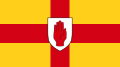 Provincial Flag of Ulster
 -
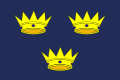 Provincial Flag of Munster
 -
 Provincial Flag of Leinster
 -
 Provincial Flag of Mide, the former fifth province of Ireland


Demographics and politics
| Province | Flag | Irish name | Population (2011) | Area (km²) | GDP (euro) (2012) | GDP per capita (euro) (2012) | Density | Number of Counties† |
Chief city |
|---|---|---|---|---|---|---|---|---|---|
| Leinster | Laighin Cúige Laighean |
2,504,814 | 19,800 | 100 bn | 40,000 | 126.5 | 12 | Dublin | |
| Ulster | Ulaidh Cúige Uladh |
2,106,296‡ | 21,882 | 50 bn | 23,000 | 96.3 | 9 | Belfast | |
| Munster | Mumhain Cúige Mumhan |
1,246,088 | 24,675 | 50 bn | 40,000 | 50.5 | 6 | Cork | |
| Connacht | Connachta Cúige Chonnacht |
542,547 | 17,788 | 15 bn | 30,000 | 30.5 | 5 | Galway | |
| Note 1: † "Number of Counties" is traditional counties, not administrative ones. Note 2: ‡ Population for Ulster is the sum of the 2011 census results for counties of Ulster in Republic of Ireland and the 2011 census results for Northern Ireland.[19] Population for other provinces is all 2011 census results. | |||||||||
Poetic description
This dinnseanchas poem named Ard Ruide (Ruide Headland) poetically describes the kingdoms of Ireland. Below is a translation from Old Irish:
Connacht in the west is the kingdom of learning, the seat of the greatest and wisest druids and magicians; the men of Connacht are famed for their eloquence, their handsomeness and their ability to pronounce true judgement.
Ulster in the north is the seat of battle valour, of haughtiness, strife, boasting; the men of Ulster are the fiercest warriors of all Ireland, and the queens and goddesses of Ulster are associated with battle and death.
Leinster, the eastern kingdom, is the seat of prosperity, hospitality, the importing of rich foreign wares like silk or wine; the men of Leinster are noble in speech and their women are exceptionally beautiful.
Munster in the south is the kingdom of music and the arts, of harpers, of skilled ficheall players and of skilled horsemen. The fairs of Munster were the greatest in all Ireland.
The last kingdom, Meath, is the kingdom of Kingship, of stewardship, of bounty in government; in Meath lies the Hill of Tara, the traditional seat of the High King of Ireland. The ancient earthwork of Tara is called Rath na Ríthe ('Ringfort of the Kings').
See also
- ISO 3166-2:IE
- Counties of Ireland
- Kings of Ulster
- Kings of Munster
- Kings of Mide
- Kings of Connacht
- Kings of Leinster
- Kings of Airgíalla
- Kings of Ailech
Bibliography
- Bardon, Jonathan (2005). A History of Ulster. The Blackstaff Press. ISBN 0-85640-764-X.
- Byrne, Francis (2001). Irish Kings and High Kings (3 ed.). Four Courts Press. ISBN 978-1851821969.
- Connolly, S.J., ed. (2007). Oxford Companion to Irish History. Oxford University Press. ISBN 978-0-19-923483-7.
- Duffy, Seán (2014). Brian Boru and the Battle of Clontarf. Gill & Macmillan. ISBN 978-0-7171-6207-9.
- Hubert, Henri. "The Greatness and Decline of the Celts"..
- Hogan, James (1928). The Tricha Cét and Related Land-Measures. Royal Irish Academy.
- Koch, John T. "Celtic Culture: Aberdeen breviary-celticism".
- MacCotter, Paul (2008). Medieval Ireland: Territorial, Political and Economic Divisions. Four Courts Press. ISBN 978-1-84682-557-6.
- MacNeill, Eoin (1920). "The Five Fifths of Ireland". Phases of Irish History. M.H. Gill & Son, Ltd..
- MacNeill, John (1911). Early Irish Population-Groups: Their Nomenclature, Classification, and Chronology. Royal Irish Academy.
- Stafford, Fiona J.; Gaskill, Howard. "From Gaelic to Romantic: Ossianic Translations".
References
- ^ a b c d e f g h Koch, pp. 459-460.
- ^ a b c d e f g h i Duffy (2014), pp. 8-10.
- ^ a b Byrne.
- ^ MacCotter, p. 46.
- ^ Duffy (2014), pp. 21.
- ^ Bardon, p. 14.
- ^ Duffy (2005), pp. 490-1.
- ^ a b Duffy (2014), pp. 24.
- ^ Duffy (2005), p. 12.
- ^ a b c d e f g h i j k Falkiner, Caesar Litton. The Counties of Ireland: An Historical Sketch of Their Origin, Constitution, and Gradual Delimitation. Royal Irish Academy.
- ^ Connolly, p. 12.
- ^ John G. Crawford, Anglicising the Government of Ireland: The Irish Privy Council & the Expansion of Tudor Rule 1556–1578, Blackrock, 1993
- ^ Desmond Roche, Local Government in Ireland, Dublin, 1982
- ^ a b c d e f g h i j k Eoin MacNeill (1920). The Five Fifths of Ireland.
- ^ a b c Hogan, p. 1
- ^ a b c d Hurbert, pp. 169-171
- ^ a b c d e Stafford & Gaskill, p. 75
- ^ a b John MacNeill, p. 102
- ^ Northern Ireland CSO, Northern Ireland Census Results 2011
