
Red Deer River
| Red Deer River | |
|---|---|
 | |
| Physical characteristics | |
| Mouth | South Saskatchewan River near Empress 50°55′23″N 109°53′42″W / 50.92315°N 109.89493°W |
• elevation | 579 meters (1,900 ft) |
| Length | 724 kilometers (450 mi) |
The Red Deer River is a river in Alberta, Canada. It is a major tributary of the South Saskatchewan River and is part of the larger Saskatchewan-Nelson system that empties into Hudson Bay.[2]
Red Deer River has a total length of 724 kilometers (450 mi) and a drainage area of 45,100 square kilometers (17,400 sq mi). Its mean discharge is 70 m³/s.[1]
The river got its name from the translation of Was-ka-soo which means "elk river" in the Cree.[citation needed]
Communities located along the Red Deer River include Sundre, Red Deer, Blackfalds and Drumheller. The city of Brooks is also located in the Red Deer River Basin.
Course


The river originates on the eastern slopes of the Canadian Rockies, in the Sawback Range inside Banff National Park, and then flows east through the mountains and foothills region. It turns north-east before Sundre and keeps this heading to the city of Red Deer, where it turns east, and then south before Stettler. It flows south with its valley protected by provincial and regional parks such as Tolman Badlands Heritage Rangeland, Dry Island Buffalo Jump Provincial Park, Dry Island Corridor and Midland Provincial Park. At Drumheller it has a south-east direction, and while it flows through Dinosaur Provincial Park it turns east and flows to the Alberta/Saskatchewan border, which it crosses at Empress. It flows for 16 km through Saskatchewan before it merges into the South Saskatchewan River.
Tributaries
|
|
The waters of Ewing Lake, Little Fish Lake also flow into the Red Deer River.
Gallery
-
 Flowing through the city of Red Deer
 -

-

-
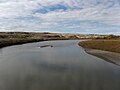 Red Deer River north of Jenner, Alberta


Environmental Concerns
Pipeline Leaks
The Red River is the water source for the City of Red Deer and the surrounding area. Pipelines cross under the river and there have been leaks disrupting access to potable water. [4] Increased water flow of the Red Deer River system during heavy rainfall in June 2008 eroded supporting soil, freely exposing a section of Pembina Pipeline Corporation's Cremona crude oil pipeline to the Red Deer River currents. About 75 to 125 barrels of crude oil flowed upstream from the breakpoint under a Red Deer River channel, leaving an oily sheen on Gleniffer Reservoir and 6800 kilograms (15 000 lbs) of oil-soaked debris. [5] [6] The remediation was not completed until 2011. [7]
Heavy rains in early June 2012 caused a similar but larger leak on a Plains Midstream Canada 46-year-old pipeline on a Red River tributary, Jackson Creek (Alberta) (51°52'19" 114°36'23") near Gleniffer Lake (Alberta) and Dickson Dam, [8]which spilled approximately 1000 and 3000 barrels (160,000-475,000 litres) of light sour crude into the Red Deer River. [7] [9]
See also
- List of longest rivers of Canada
- List of rivers of Alberta
- List of rivers of Saskatchewan
- Glacial Lake Bassano
References
- ^ a b Atlas of Canada. "Rivers in Canada". Retrieved 2007-05-01.
- ^ [1]
- ^ [2]
- ^ [3]
- ^ Brian Temple; Doug Buechler; Dave Grzyb; Murray Barber; Jenny Miller; Phil Hendy; Mike Bevan (February 11, 2009). ERCB Investigation Report: Pembina Pipeline Corporation, Crude Oil Pipeline Failure, June 15, 2008 (.pdf) (Report). Energy Resources Conservation Board. Retrieved 2012-06-16. The pipeline, leased to Pembina, was built in 1959.
- ^ "Oil leaks into popular Alberta lake: Company previously fined in B.C. for pipeline rupture, spill in 2000". CBC. June 6, 2008. Retrieved 2012-06-16.
- ^ a b Bob Weber (June 14, 2012). "Alberta pressured to include leaks in environmental monitoring plan". Financial Post. Retrieved 2012-06-16.
- ^ Name: Jackson Creek
- ^ Stephen Ewart (June 16, 2012). "Ewart: Calls growing for probe of aging pipeline system: Recent spills highlight ongoing risk". Calgary Herald. Retrieved 2012-06-16.
| Rivers | | |
|---|---|---|
| Waterfalls | ||
| Lakes | ||
| Reservoirs | ||
| Glaciers | ||
| Other | ||