
Panama City: Difference between revisions
Restoring info at the intro, and editing it to eliminate any advertisement |
|||
| Line 85: | Line 85: | ||
Panama City has been for 7 years in the top 5 places for retirement in the world according to International Living Magazine<ref>[http://www.internationalliving.com/internal_components/further_resources/09_01_07_retirement “International Living 2007 Retirement Index”]</ref> |
Panama City has been for 7 years in the top 5 places for retirement in the world according to International Living Magazine<ref>[http://www.internationalliving.com/internal_components/further_resources/09_01_07_retirement “International Living 2007 Retirement Index”]</ref> |
||
Panama City has a nice skyline seen from the bay, including mostly apartment buildings, but office complexes and hotels as well. Panama City is an important hub for international banking and commerce. The telephone service is advanced, so international calls are usually easy to make; Internet is widespread; and Panama City's international airport is quite modern, offering daily flights to many international destinations.<ref>[http://www.internationalliving.com/countries/panama/live “International Living -Panama Live (See at the infraestructure paragraph)"]</ref> |
|||
The city has a dense skyline compared to most Central American cities. Due to its geographic location, Panama City is also a hub for international banking and commerce. |
|||
Panama City was chosen to be the [[American Capital of Culture]] for the year 2003 (jointly, with [[Curitiba]], [[Brazil]]). |
Panama City was chosen to be the [[American Capital of Culture]] for the year 2003 (jointly, with [[Curitiba]], [[Brazil]]). |
||
Revision as of 17:05, 24 January 2008
Panama City
Ciudad De Panamá | |
|---|---|
 Panama City's skyline at night | |
 Flag  Seal | |
| Province | Panama |
| Districts | 23 Panama boroughs |
| Founded | August 15, 1519 |
| Seat of the Government | November 3, 1903 |
| Capital of the Nation | November 3, 1903 |
| Government | |
| • Type | Constitutional Democracy |
| • Mayor | Juan Carlos Navarro (PRD) |
| Area | |
| • City | 275 km2 (106 sq mi) |
| • Metro | 2,560.8 km2 (988.7 sq mi) |
| Elevation | 576 m (1,890 ft) |
| Population (2000) | |
| • City | 1,063,000 |
| • Density | 275/km2 (129/sq mi) |
| Website | http://www.municipio.gob.pa |
| HDI (2006) 0.937 – high | |
| UNESCO World Heritage Site | |
|---|---|
 | |
| Criteria | Touristic, Cultural: II, IV, VI |
| Reference | 790 |
| Inscription | 1997 (21st Session) |
| Extensions | 2003 |
Panama City (Spanish: Ciudad de Panamá) is the capital and largest city of the Republic of Panama. It has a population of 708,738, with a total metro population of 1,063,000, and it is located at the Pacific entrance of the Panama Canal, at 8°58′N 79°32′W / 8.967°N 79.533°W. Panama City is the political and administrative center of the country. Juan Carlos Navarro is Panama City's current mayor.
Panama City has been for 7 years in the top 5 places for retirement in the world according to International Living Magazine[1]
Panama City has a nice skyline seen from the bay, including mostly apartment buildings, but office complexes and hotels as well. Panama City is an important hub for international banking and commerce. The telephone service is advanced, so international calls are usually easy to make; Internet is widespread; and Panama City's international airport is quite modern, offering daily flights to many international destinations.[2]
Panama City was chosen to be the American Capital of Culture for the year 2003 (jointly, with Curitiba, Brazil).
History
The city was founded on August 15, 1519, by Pedro Arias de Ávila. Within years of its founding, the city became a launching point for the exploration and conquest of Peru and a transit point for gold and silver headed towards Spain. In 1671, the English pirate Henry Morgan, with the help of a band of 1400 men, attacked and looted the city, which was subsequently destroyed by fire. The ruins of the old city still remain and are a popular tourist attraction known as Panamá la Vieja (Old Panama). It was rebuilt in 1673 in a new location approximately 5 miles southwest of the original city. This location is now known as the Casco Viejo (Old Quarter) of the city.
Two years after the start of the California Gold Rush in 1848, the Panama Railroad Company was formed,[3] but the railroad did not begin operation until 1855.[4] Between 1848 and 1869, the year the first transcontinental railroad was completed in the United States, about 375,000 persons crossed the isthmus from the Atlantic to the Pacific, and 225,000 in the opposite direction. That traffic greatly increased the prosperity of the city during that period.
The construction of the Panama Canal was of great benefit to the infrastructure and economy. Of particular note are the improvements in health and sanitation brought about by the American presence in the Canal Zone. These include the eradication of yellow fever and malaria and the introduction of a first-rate water supply system. However, most of the workers involved in the construction of the canal were brought in from the Caribbean, which created unprecedented racial and social tensions in the city. [citation needed]
During World War II, construction of military bases and the presence of larger numbers of U.S. military and civilian personnel brought about unprecedented levels of prosperity to the city.[citation needed] Panamanians had limited access, or no access at all, to many areas in the Canal Zone neighboring the Panama City metropolitan area. [citation needed] Some of these areas were military bases accessible only to United States personnel. Tensions arose between the people of Panama and the U.S. citizens living in the Panama Canal Zone. This erupted in the January 9, 1964 riots.
In the late 1970s through the 1980s Panama City became an international banking center, bringing a lot of undesirable attention as an international money-laundering center. In 1989 after nearly a year of tension between the United States and Panama, President George H. Bush ordered the invasion of Panama to depose the leader of Panama, General Manuel Noriega. As a result of the action a portion of the El Chorrillo, a neighborhood which consisted mostly of old wood-framed buildings dating back to the 1900s, was destroyed by fire. Eventually, the U.S. helped finance the construction of large cinderblock apartment buildings to replace the destroyed structures. Panama City remains a major banking center, although with very visible controls against money laundering. Shipping is handled through port facilities in the area of Balboa operated by the Hutchison Whampoa Company of Hong Kong and through several ports on the Caribbean side of the isthmus. Balboa, which is located within the greater Panama City metropolitan area, was formerly part of the Panama Canal Zone, and in fact the administration of the former Panama Canal Zone was headquartered there.
Panama City as a tourism destination
The city has numerous tourist attractions including world-class hotels and restaurants. Particularly interesting for tourists are various sites located in the old quarter (also commonly referred to as "Casco Viejo", "Casco Antiguo" or "San Felipe"), including
- Las Bóvedas,[5] literally The Vaults, a waterfront promenade jutting out into the Pacific;

A Panamanian colonial village in Casco Viejo - The National Institute of Culture Building and across from it, the French Embassy;
- The Cathedral on Plaza de la Catedral;
- Teatro Nacional, a recently renovated performance center, with outstanding natural acoustics; It provides an intimate performance environment and seating for about 800 guests.
- Museo del Canal Interoceánico (Interoceanic Canal Museum);
- Numerous restaurants located near the French embassy.
- Palacio de las Garzas (Heron's Palace), the official name of the presidential palace. There are real herons in the compound.


The area immediately east of the Pacific entrance of the canal--known as the Amador Causeway[6]-- is currently being developed as a major tourist center. Currently the Smithsonian Tropical Research Institute operates a station and a small museum open to the public on Culebra Island, just off the island of Naos (See inset). A new museum, The Bridge of Life Museum, is currently under construction on the causeway. The Bridge of Life Museum was designed by the American architect Frank Gehry famous for the Guggenheim Museum Bilbao and the Disney Concert Center in Los Angeles and it is scheduled to be completed in 2009.[7]
Demographics
The City Proper is around 813,097 inhabitants in the 23 Panama City Boroughts.[8]
Economic overview
Panama City has a total of 79 banks, two of them being national, the city also boasts several tourist attractions, and is also a stopover for other nearby destinations in the country as well as a tourist destination in its own right, the city is also responsible for the production of about 55% of the country's GDP, this due to the fact that most businesses and premises are located in the city and its metro area.[9]
The communications systems are highly developed and are among Central America's most reliable. Internet use is widespread due to Panama's high income.[10]
Nature in the City

Panama City is located between the Pacific Ocean and many tropical rain forests. The Parque Natural Metropolitano (Metropolitan Nature Park), stretching from Panama city along the Panama Canal, has several unique bird species and other animals such as tapir, puma, alligators, etc. At the Pacific entrance of the canal is the Centro de Exhibiciones Marinas (Marine Exhibitions Center), a research center for those interested in tropical marine life and ecology. Centro de Exhibiciones Marinas is managed by the Smithsonian Tropical Research Institute.
Tropical forests around Panama City are vital for the functioning of the Panama Canal. These forests provide the canal with the watershed required for its operation (a rare example of a vast engineering project in the middle of the forest which actually helped preserve that very nature). Due to the importance of the Canal to the Panamanian economy, tropical forests around the canal have been kept in an almost pristine state. Along the western side of the Canal is the Parque Nacional Soberania (Sovereignty National Park) which includes Summit botanical gardens and a zoo. In this national park, the best known trail is the Pipeline Road, very popular among birdwatchers.[11]
Urban Problems
Due to many years of urban growth without any planning, Panama City is now facing several urban problems. With the large number of skyscrapers being built, population density is increasing far beyond previously expected [12] . Neighborhoods like El Cangrejo and El Carmen, first designed for a density of 10,000 inhabitants per square kilometer (26,000/sq mi) are now reaching 35,000 inhabitants per square kilometer (91,000/sq mi)[13]. The city's downtown streets are overcrowded with cars, creating many traffic problems for commuters[14]. Panama City's existing water supply piping system isn't getting enough maintenance and is causing several water pollution-related problems Another important problem is the shape of the city. Instead of the usual circular shape, Panama City has assumed the form of a narrow strip along the coast, expanding into the northeast. This is mainly because Panama City is limited in the south by the Pacific Ocean, in the north by the protected lands of the Metropolitan Park and other parks of the Panama Canal Basin, and in the west boundary by the Panama Canal itself with more protected land areas beyond it. Subsequently Panama City has expanded mostly eastwards.
Despite these urban planning problems[15], Panama City's poor population drops as its Shanty towns develop to become residential districts and abandon the widespread poverty. These former slums are now housing for most of the Panamanian lower middle class. There are currently only two slums left in the city, the largest being Cerro Patacón (Plantain Mountain) and El Chorrillo, which is recovering from its decadence thanks to the investing opportunities and the historical reminisence of the town.
Economic overview
Panama City has a total of 79 banks, two of them being national, the city also boasts several tourist attractions, and is also a stopover for other nearby destinations in the country as well as a tourist destination in its own right, the city is also responsible for the production of about 55% of the country's GDP, this due to the fact that most businesses and premises are located in the city and its metro area.[16]
The communications systems are highly developed and are among Central America's most reliable. Internet use is widespread due to Panama's high income.[17]
Infraestructure
According with Skyscraperpage, Panama City currently has more than 110 skyrise projects been constructed.[18] With 127 highrise buildings already built. And it holds the 65th place in the world by highrise buildings count.[19]
The Centennial Bridge, that crosses the Panama Canal earned the American Segmental Bridge Institute prize of excelence toguether with other 7 bridges in the Americas. [20]
Healthcare
Panama City counts with 11 medical complexes. Around 45% of Panama physicians are located in Panama City. [21]
Panama offers good-quality medical care and modern hospitals in the metropolitan area, however, the more isolated the location, the harder will be to access these services. The hospitals offer first-rate medical care. Many Panamanian doctors are U.S.-trained, and the standards at the top hospitals compare favorably to those in the United States. [22]
Transportation
Panama City's international airport, Tocumen International Airport, located on the eastern outskirts of the city, is easily accessible. There are direct flights between Tocumen and New York, Newark, Washington D.C., Los Angeles, Houston, Orlando, Miami, Atlanta, Madrid and all major cities in the Caribbean area, Central America and South America. Panama City also has a regional airport Marcos A. Gelabert, located in an area once occupied by Albrook Air Force Base. Marcos A. Gelabert Airport is the main hub for regional flights within Panama and the Pearl Islands in the Pacific.
Panama City has an extensive and efficient, yet confusing to tourists, form of public transportation consisting of colorful painted buses colloquially known as diablo rojo. A diablo rojo is usually "customized" or painted with bright colors, usually depicting famous actors, politicians or singers. It is now popular all over the city (and also in neighboring towns) for bus drivers to personally customize the interior and exterior of their diablo rojo. There is also a bus terminal near the Marcos A. Gelabert airport which together with the airport serves as the main transport hub for the rest of the country.
Sports
- Association Football
- Panama City is home to three professional teams in the country's top football league, ANAPROF:
- Panama City is also home to two professional teams in the country's second level league, Primera A (Segunda Division):
- Deportivo Italia
- Rio Abajo F.C.
Photographs of the city
-
 The belltower of the St. John Bosco Basilica.
 -
 View from the University of Panama grounds.
 -
In Casco Viejo.
-
A Casco Viejo street paralleling the water, near to the Hospedaje Casco Viejo.


-
 A view of the high rise of modern Panamá City, across the Bahía de Panamá, from the old harbour near the Mercado Publico in San Felipe (Casco Viejo).
 -
 Causeway connecting Naos, Perico and Flamenco Islands to the mainland. A bicycle path parallels the roadway.
 -
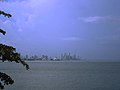 Panama City at dusk as seen from the Bay of Panama.
 -
Casco Antiguo's cathedral near the central square in Casco Viejo, Panama City


-
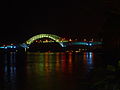 The entrance to the Panama Canal from the Pacific Ocean, the Bridge of the Americas at night.
 -
 Panama City's skyline seen from Corredor Sur, a toll highway that links the city with Tocumen International Airport.
 -
French Plaza (Plaza de Francia) in Casco Viejo. In the image, a monument erected in the Plaza de Francia in honor of the workers and French engineers that participated in the construction of the Panama Canal.


www.travel-in-panama.com
Sister Cities
See also
References
- ^ “International Living 2007 Retirement Index”
- ^ “International Living -Panama Live (See at the infraestructure paragraph)"
- ^ The Panama Railroad from Trainweb
- ^ Harper's New Monthly Magazine March 1855, Volume 10, Issue 58, p.543
- ^ Las Bovedas: Casco Viejo Bar
- ^ Jogging in Paradise...but where is everbody? The Panama Report
- ^ Panama:Bridge of Life|Biodiversity Museum
- ^ “Panama City Hall (Spanish”
- ^ http://municipio.gob.pa
- ^ “International Linving -Panama Live (See at the infraestructure paragraph)"
- ^ Canopy Tower, a famous birdwatchers hotel
- ^ "burica wordpress"
- ^ “La Prensa Newspaper”
- ^ “La Prensa Newspaper”
- ^ "Panama News"
- ^ http://municipio.gob.pa
- ^ “International Living -Panama Live
- ^ “Skyscraper page Panama City”
- ^ “Skyscraper page Cities List”
- ^ “La Prensa Newspaper”
- ^ “Panama City Hall – Healthcare”
- ^ “International Living Healthcare Overview”