
Brentwood, New York: Difference between revisions
Brentwoodny (talk | contribs) |
Brentwoodny (talk | contribs) |
||
| Line 156: | Line 156: | ||
[[bg:Брентуд (Ню Йорк)]] |
[[bg:Брентуд (Ню Йорк)]] |
||
[[vo:Brentwood (New York)]] |
[[vo:Brentwood (New York)]] |
||
*Christian Freeman 1852. Letter from Rev. B. F. Bowles. The Brentwood History Collection |
|||
**[http://farm1.static.flickr.com/109/366452521_b37c473ce7_o.jpg Part 1] and [http://farm1.static.flickr.com/155/366452501_b7afed7b2e_b.jpg Part 2] and [http://farm1.static.flickr.com/185/366452493_dd469c14f8_o.jpg Part 3] |
|||
Revision as of 02:21, 6 February 2008
Brentwood, New York | |
|---|---|
 U.S. Census Map | |
| Country | United States |
| State | New York |
| County | Suffolk |
| Area | |
| • Total | 10.1 sq mi (26.1 km2) |
| • Land | 10.1 sq mi (26.1 km2) |
| • Water | 0.0 sq mi (0.0 km2) |
| Elevation | 79 ft (24 m) |
| Population (2000) | |
| • Total | 53,917 |
| • Density | 5,357.3/sq mi (2,068.5/km2) |
| Time zone | UTC-5 (Eastern (EST)) |
| • Summer (DST) | UTC-4 (EDT) |
| ZIP code | 11717 |
| Area code | 631 |
| FIPS code | 36-08026 |
| GNIS feature ID | 0944688 |
Brentwood is a hamlet and CDP (census-designated place) in the Town of Islip in Suffolk County, New York on Long Island. As of the 2000 census, the CDP had a total population of 53,917.
Geography
Brentwood is located at 40°46′54″N 73°14′39″W / 40.78167°N 73.24417°WInvalid arguments have been passed to the {{#coordinates:}} function (40.781805, -73.244060)Template:GR.
According to the United States Census Bureau, the CDP has a total area of 10.1 square miles (26.1 km²), all land.
History
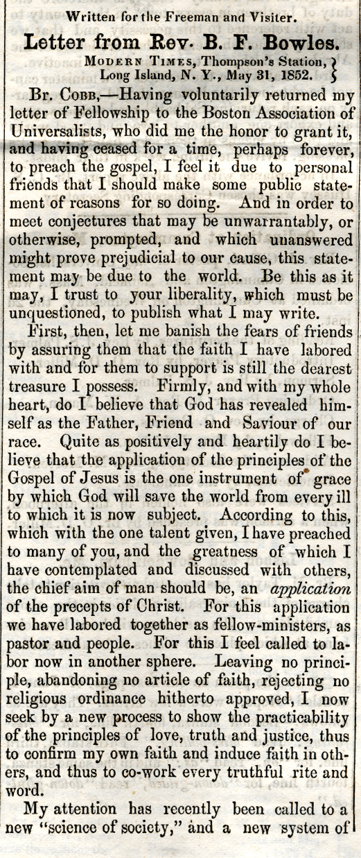
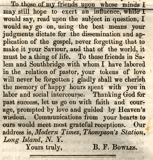
Brentwood used to be known as Modern Times. Modern Times was an individualist anarchist, utopian colony begun on March 21, 1851 on 750 acres (3 km²) of land on Long Island, New York, by Josiah Warren and Stephen Pearl Andrews. By contract, all land was bought and sold at cost, with three acres being the maximum allowable lot size. The community was said to be based in the idea of "individual sovereignty" and "individual responsibility." There was an understanding that there was to be no initiation of coercion, leaving all individuals to pursue their self-interest as they saw fit. All products of labor were considered private property. The community had a local private currency based upon labor exchange in order to trade goods and services (see Mutualism). All land was private property, with the exception of alleys which were initially considered common property but later converted to private property. No system of authority existed in the colony. There were no courts, no jails, and no police; yet, there are no reports of any problem with crime existing there. This appears to have given some credence to Warren's theories that the most significant cause of violence in society was most attributable to policies and law which did not allow complete individuality in person and property. However, the modest population of the colony might be considered a factor in this characteristic. The Civil War, as well as a gradual infiltration into the community by those that did not share the same libertarian and economic philosophy, is said to have contributed to its eventual dissolution. The colony's location is now known as Brentwood, New York. Almost all of the original buildings that existed in Modern Times have been destroyed.
Modern Times was renamed Brentwood after the village Brentwood, Essex in England.
Site of Pilgrim State Hospital, once the world's largest mental institution; now known as Pilgrim Psychiatric Center.
Though Brentwood was founded in 1851, the 150th anniversary of the community was commemorated on May 9-11, 2007.
Demographics
As of the censusTemplate:GR of 2000, there were 53,917 people, 12,580 households, and 10,894 families residing in the CDP. The population density was 5,357.3 per square mile (2,069.3/km²). There were 13,039 housing units at an average density of 1,295.6/sq mi (500.4/km²). The racial makeup of the CDP was 47.73% White, 18.06% African American, 0.57% Native American, 2.01% Asian, 0.11% Pacific Islander, 25.44% from other races, and 6.07% from two or more races. Hispanic or Latino of any race were 54.25% of the population.
There were 12,580 households out of which 46.6% had children under the age of 18 living with them, 61.2% were married couples living together, 17.4% had a female householder with no husband present, and 13.4% were non-families. 9.5% of all households were made up of individuals and 4.4% had someone living alone who was 65 years of age or older. The average household size was 4.23 and the average family size was 4.19.
In the CDP the population was spread out with 29.9% under the age of 18, 10.6% from 18 to 24, 32.8% from 25 to 44, 18.5% from 45 to 64, and 8.2% who were 65 years of age or older. The median age was 31 years. For every 100 females there were 100.2 males. For every 100 females age 18 and over, there were 97.5 males.
The median income for a household in the CDP was $59,208, and the median income for a family was $57,047. Males had a median income of $31,022 versus $25,946 for females. The per capita income for the CDP was $15,833. About 7.5% of families and 11.3% of the population were below the poverty line, including 13.7% of those under age 18 and 10.6% of those age 65 or over.
Notable Residents
- Divine Sounds - old school hip hop group - Richard and Brian Dowling
- EPMD - hip-hop pioneers, raised in Brentwood
- David W. Halderman Jr. - lieutenant, FDNY; killed during the 9/11 attacks
- Mitch Kupchak - general manager of the NBA's Los Angeles Lakers (2000-present; 2 championship rings), assistant general manager of the Los Angeles Lakers (1986-2000; 3 championship rings), forward/center for the Los Angeles Lakers (1981-1982, 1983-1986; 2 championship rings), forward/center for the NBA's Washington Bullets (1976-1981; 1 NBA All-Rookie Team honor, 1 championship ring), U.S. Olympian (basketball, 1976; 1 gold medal), UNC Chapel Hill Tar Heel (basketball, 1973-1976)
- Buddy McGirt - boxing champion and trainer
- Chris Nixon - producer/audio engineer for experimental noise superstar REPLOGEN
- William H. Ross, M.D. - psychiatrist, founder of the Ross Health Resort on Suffolk Avenue in 1898; after whom the Ross Building of Brentwood High School and Ross Nursing Home are named
- Leonard H. Tower Jr. - free Software activist, software hacker, and founding member of the Board of Directors of the Free Software Foundation
- Michael H. Waye - vice president, Marsh and McLennan; killed during the 9/11 attacks
Churches
- Christ Episcopal Church, circa 1850, Third Ave, Brentwood NY
- Hope Baptist Church
- Ministerio JesuCristo Vive, 1417 Islip Avenue, Central Islip NY 11722
- New Jerusalem Baptish Church, MacArthur Avenue, Brentwood NY
- Prince of Peace Lutheran Church, Candlewood Road
- St. Anne's R.C. Church, Second Avenue
- St. Luke's Church
Bibliography
- Dyson, Verne. A Century of Brentwood. by Verne Dyson, 1950, Brentwood: Brentwood Village Press, 1950.
- Dyson, Verne. Supplement and Index: An After-piece to A Century of Brentwood, Brentwood: Brentwood Village Press, 1953.
- Wunderlich, Roger. Low Living and High Thinking at Modern Times, N.Y. Syracuse: Syracuse University Press, 1992. ISBN 0-8156-2554-5
- Christian Freeman 1852. Letter from Rev. B. F. Bowles.
See also
- Academy of Saint Joseph
- Brentwood High School (Brentwood, New York)
- Maslow-Toffler School of Futuristic Education
- List of anarchist communities - Modern Times (1851 to late 1860s)
- Modern Times (intentional community)