
Canton Viaduct: Difference between revisions
mNo edit summary |
mNo edit summary |
||
| Line 254: | Line 254: | ||
CORNERSTONE - |
CORNERSTONE - |
||
Is there a chamber in the cornerstone containing a time capsule? |
Is there a chamber in the cornerstone containing a time capsule - in between the stones or under the bottom stone? |
||
When exactly was the cornerstone set in the south end, west parapet? (as the structure neared completion...) Why there? |
When exactly was the cornerstone set in the south end, west parapet? (as the structure neared completion...) Why there? |
||
Does "western" end mean the west side of the south end or just the south end? If it refers to the south end then which wall was the cornerstone laid in - east or west? |
Does "western" end mean the west side of the south end or just the south end? If it refers to the south end then which wall was the cornerstone laid in - east or west? |
||
Revision as of 18:37, 17 March 2009
Canton Viaduct | |
|---|---|
 Canton Viaduct with Revere Copper Mill in the background | |
| Coordinates | 42°09′32″N 71°09′14″W / 42.1589°N 71.1539°W |
| Carries | Presently services:
|
| Crosses |
|
| Locale | Canton, Massachusetts |
| Official name | Canton Viaduct
Nicknames:
|
| Maintained by | Amtrak |
| Heritage status | |
| Preceded by | None, the Canton Viaduct was the first and only bridge to span the Neponset Valley |
| Followed by | NA, bridge still in active mainline use |
| Characteristics | |
| Design | Considered a "Multiple Arch" bridge but it is more accurately described as a Double Blind Arcade Viaduct. |
| Material | Granite from local quarries |
| Total length | 615' built on a 1 degree curve which if extended would form a circle with a 42 mile circumference |
| Width | Varies:
|
| Height | Varies:
|
| Longest span | 26' (original semi-circular vehicle arch) |
| No. of spans | 50 total:
|
| Piers in water | 7 |
| Load limit | Unknown:
|
| Clearance below | Varies:
|
| History | |
| Designer | |
| Construction start | The Foundation Stone was laid on April 20, 1834. The 'construction phase' started prior with surveying, excavating, mobilization, site preparation, etc. Construction of the wing wall abutments is assumed to have been completed prior to the Foundation Stone being laid. |
| Construction end | July 28, 1835, but it may have been completed prior to the Opening date from various accounts of horse-drawn cars passing over it starting in June. The Canton Viaduct is assumed to have been 'substantially complete' in June and 'finally complete' in July. |
| Opened | "Tuesday, July 28, 1835 saw the first regular passage over the viaduct", as reported by the Boston Advertiser, however The History Of Providence County, Rhode Island states, "On the 11th of June (1835) the road was opened for traffic". There is confusion over "regular passage", which is assumed to be steam locomotives and "opened for traffic", which could mean horse drawn cars. Perhaps the structure was not considered "finally complete" until "regular passage" was established between Boston, Massachusetts and Providence, Rhode Island via steam power. "Irregular passage" may have existed prior in the form of horse drawn cars, semi-functioning or late delivered steam locomotives. |
| Statistics | |
| Daily traffic |
|
| Location | |
 | |
Canton Viaduct is a stone viaduct in Canton, Massachusetts erected in 1835 by the Boston and Providence Railroad Corporation 0.3 mile south of Canton Junction, for their mainline service between Boston, Massachusetts and Providence, Rhode Island. It is the only known structural Double Blind Arcade viaduct ever built in the United States. The "stone bridge" was eventually named after the town and was the largest bridge in the nation when it was built. It has been in continuous service for 174 years (as of 2009) and now carries high-speed passenger and freight rail service. Its location on Amtrak's Northeast Corridor is at milepost 213.74, reckoned from Penn Station in New York City.
History
The Canton Viaduct was erected in 1835 by the Boston and Providence Railroad Corporation, one of the first New England railroads, shortly after its 1831 founding. Without Joseph Warren Revere, owner of the Revere Copper Company and a Director of the Boston and Providence Railroad Corporation, the Canton Viaduct would not have been built. There were clearly better routes through other towns for the location of the railroad line from Boston to Providence. However, building the railroad through Canton placed the line close to his mill, where a spur[2] connected the mill to Canton Junction and undoubtedly gave a boost to his copper business. It was designed by Army Captain William Gibbs McNeill and Army Major George Washington Whistler and built by Dodd & Baldwin. Tsar Nicholas I of Russia sent workmen to create technical drawings of the Canton Viaduct in order to build two duplicate bridges on the Moscow–Saint Petersburg Railway.
Design & construction

The bridge resembles a giant, rusticated stone wall supporting a train deck about 60 feet (18 m)[1] above the Canton River, a tributary of the Neponset River. The river passes through six semi-circular arches in the bridge, coming to a waterfall about 50 feet further downstream. The coping is supported by 42 segmental arches (21 on each side) that join the tops of 22 buttresses visible on the exterior of the structure. The buttresses are more accurately described as piers because they pass through the entire structure and are tied to the walls externally and internally rather than being solely external supports. The structure is actually hollow, composed of two parallel (longitudinal) walls each five feet thick with a five foot gap between them with occasional tie stones.[3] Further details are available in the Construction Specifications. The structure is often identified as a "multiple arch" bridge, based on its appearance. However, bridges are classified by their support method, so it is more accurately described as a Double Blind Arcade viaduct, because the walls provide the main support for the deck (59%), with the the arches providing the remaining 41%.
The Canton Viaduct contained 14,483 cubic feet (15,800 perches) of granite, which weighs approximately 66,000,000 pounds (33,000 short tons), prior to its redecking with concrete in 1993. It is unknown if these values for the amount of material include the foundation, piers, deck, parapet walls and wing wall abutments or if the vehicle and river arch openings were subtracted. The two major groups of men who built the Canton Viaduct were the Scottish (Freemasons) stone cutters and masons and the Irish, who laid the rough stone and built the gravel roadbed. Each facing stone has a Mason's mark to identify who cut the stone. The facing stone is Riebeckite from Moyles Quarry (a.k.a. Canton Viaduct Quarry), now part of Borderland State Park. It is laid in a pattern closely resembling a Flemish Bond design. The foundation and backing stone is from a quarry near Dunbar Street in Canton.
The Canton Viaduct cost US$93,000 to build in 1835, which equates to $2.4 million in 2009 dollars. Construction took 15 months, 8 days from laying of the Foundation Stone to the day the viaduct saw its first "regular passage".
The majority of the viaduct is over land (71%), while 29% is in the river. In addition to the six arches for the river, one large arch was provided in the original construction for Neponset Street. In 1786 the way leading from the Stone Factory Village to Washington Street under the viaduct was called Billings Lane, after William Billings II. In 1790 Billings Lane became known as "Ye Road from Ye Schoolhouse on Taunton Road to Ye Old Forge"; it is not certain when the name changed to Neponset Street.[4]
Renovations & repairs
- Original Rails - The original granite slab deck had two channels carved the entire length of the viaduct (discovered during the 1993 renovation) for longitudinal sleepers to provide continuous support of the rails. Typically, strap rails[5] or bridge rails[6] were laid on longitudinal sleepers; if used, these early rails would have been replaced with flanged rails by 1840. An early report indicates T-rails being used on the railroiad.
- Longitudinal Sleepers - It is unknown if longitudinally supported rails were used on the viaduct due to a report that says, "the top of the viaduct was rounded by ballast and the rails were placed on the crown". The longitudinal sleepers may have been abandoned for traditional cross ties before the viaduct was opened for service. If used, the longitudinal sleepers they may have been abandoned when the original rails were replaced around 1840. If not then, they would have been replaced when the line was double tracked in 1860. It is unknown if longitudinal sleepers were used thoughout the railroad but photos[2] appear to show longitudinal sleepers at Canton Junction in 1871. A 1829 report from the Massachusetts Board of Directors of Internal Improvements describes how the railroad from Boston to Providence was to be built. The report states, "It consists of one pair of tracks composed of long blocks of granite, about one foot square, resting upon a foundation wall extending to the depth of 2-1/2' below the surface of the ground, and two feet wide at the bottom". It seems clear from the estimate that longitudinal sleepers were originally to be used throughout the railroad, however railroad technology was developing rapidly at this time so when the railroad was built two years later a more modern method of track laying may have been used. This report also calls for using horse drawn wagons and carriages at 3 MPH instead of steam locomotives. Another early report calls for the use of inclined planes to cross Neponset Valley, but due to a fatal accident on the Granite Railroad in 1832 a bridge (the Canton Viaduct) was built to span the valley instead.
- Ballast - If longitudinal sleepers were used on the viaduct the channels would have held the sleepers in place so the viaduct's original tracks may not have been non-ballasted. The tracks may have been ballasted when the longitudinal sleepers were abandoned for traditional cross ties unless the cross ties were fastened to them. If not then, the viaduct tracks would have been ballasted when the line was double tracked in 1860. A photo from 1910 of the top of the viaduct shows dirt between the ties and tracks so this material may have been used before traditional gravel ballast.
- 1860 - The 3'-8" high granite parapets were removed; the cornerstone was tossed off the viaduct; this stone is the last known remnant of the parapet walls; it is not known if any parapet stones fell into the river during the renovation. The granite parapets were replaced with a heavy wooden fence; a hard pine timber guard rail was bolted to the tops of the walls to retain the new ballast and a second track was added. The roadbed was originally built to accommodate two sets of tracks, but only one set was installed.
- 1880 - The wooden fence was removed and replaced with a cantilevered iron fence and railings from the Edgemoor Iron Company.
- 1887 - Safety tracks are placed on the viaduct on April 15 to prevent trains from falling off the side of the bridge when derailed.
- 1906 - Heavy timbers are supporting a work platform in this post card dated October, 15. It appears the segmental deck arch (to the east of the original vehicle arch) is being repaired and suggests the deck arches were not strong enough to handle the ever-increasing loads or were deteriorating.
- 1909 - A segmental arch stone dropped out of place and the arch was badly cracked (the fourth arch east of the original vehicle arch); stonemasons began repairing it on Sunday, December 19. An article titled, "More Trouble with the Viaduct at Canton Junction" in the December 24 edition of the Canton Journal describes this as the second arch to have given way. It is unknown if this "second arch" was a deck arch, the vehicle arch or a river arch, however the third river arch from the northeast end was repaired that same year.
- 1910 - Reinforced concrete arches (42 total, 21 on each side) were added under each segmental granite deck arch. A report from this year may describe the first interior inspection.
- 1912 - An interior inspection occurred in late October; a large stone was removed to allow access and three platforms with ladders were erected inside to facilitate inspection of the walls and underside of the deck. There were no broken or cracked stones and all joints were still full of good hard mortar. A photo from the inspection shows the formation of stalactites under the deck indicating water penetration which may have caused the deck arch problems from freeze/thaw cycles resulting in frost disintegration.
- 1952 - A second (concrete) segmental vehicle arch was cut next to the original granite semi-circular vehicle arch to accommodate northbound traffic on Neponset Street. It is presumed the interior of that chamber was inspected during this time.
- 1965 - A USCGS bench mark was placed on west side of the segmental concrete vehicular arch.
- 1993 - The Massachusetts Bay Transportation Authority rehabilitated the bridge for Amtrak's high-speed Acela Express train service. The main objectives were to widen and strengthen the bridge with a new cantilevered, precast, prestressed concrete deck, replace the concrete arches added under each segmental deck arch, and perform electrification. During this renovation a series of parallel granite retaining walls were discovered behind the abutments. Their intended purpose was presumably to reduce ground pressure, control erosion and provide stability as trains exited the bridge; a photo from 1871[2] may have captured one of these walls.
- 1995 - Three interior inspections were performed in the winter by structural engineers using rock climbing equipment. The inspectors noticed small, insignificant cracks in the walls and larger cracks in the deck stones that eventually lead to the deck being replaced. The stones of the viaduct were placed in such a way as to allow interior access at just three locations. Occasional tie stones or chinking stones connected the walls with some having large stones placed on them, the purpose off which is unknown. The local film crew noticed rock crystal formation taking place, associated with the moist air inside and a rotting wooden platform. They also noticed occasional connecting members made from thin wood or iron; it is unknown if the platforms and small connecting members were erected during the original construction or for the 1912 inspection. Other stones jutted out into the airspace but did not reach the opposite side; these stones were thought to have been used as ledges for workers to stand on as the structure rose in height.
- 1999 - Canton Viaduct Park was created from deck stones removed during the 1993 renovation. The park is located next to the waterfall and contains the viaduct's cornerstone, a commemorative plaque, a walking path and a bench for visitors.
Recognition
- The bridge was listed on the National Register of Historic Places in 1984.[7]
- The viaduct has been designated a National Historic Civil Engineering Landmark by the American Society of Civil Engineers.
- The Canton Viaduct will celebrate its 175th anniversary (Demisemiseptcentennial or Quartoseptcentennial) on July 28, 2010.
- For Canton's 175th anniversary commemorative medals were created with the Canton Viaduct engraved.
- For the Boston Society of Civil Engineer's 150th Anniversary a commemorative pen and ink limited edition print was commissioned featuring 13 significant design and construction achievements in Massachusetts from 1804 - 2002. The Canton Viaduct is shown at the bottom righ corner of the print.
Gallery
-
Canton Viaduct commemorative plaque reads: "CANTON VIADUCT Constructed in 1835 NATIONAL REGISTER OF HISTORIC PLACES Placed by the Canton Historical Commission Dedicated on July 4, 1993 NATIONAL HISTORIC CIVIL ENGINEERING LANDMARK (blue shield logo reads:) AMERICAN SOCIETY OF CIVIL ENGINEERS 1852 Designated by the American Society of Civil Engineers Dedicated in 1999 The Canton Viaduct is one of the two oldest surviving multiple arch stone railroad bridges still in active mainline use in the United States"
-
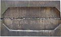
 Canton Viaduct cornerstone (front) reads: "This Viaduct Erected by the B. & P. R. R. Co. Directors T. B. WALES. Pre. W. W. WOOLSEY. P. T. JACKSON. J. W. REVERE. J. F. LORING. C. H. RUSSELL. C. POTTER. J. G. KING." The two Directors obscured names are W. W. Woolsey and P. T. Jackson. The cornerstone is actually two stones 5' Long x 3' High x 1.5' Wide = 22.5 CuFt x 168 Lbs/CuFt (granite) = 3,780 Lbs - almost 2 tons. As the structure neared completion the cornerstone was set in the south end, west parapet, presumably for easier access since the north has a steeper grade. During the 1860 renovations the cornerstone was tossed off the viaduct and lay in a field at the bottom for a long while. It was then raised to the top and set at the north end, west side (visible above the wing wall abutment picture below). In 1995 it was relocated to Canton Viaduct Park, facing west.
 -
 Canton Viaduct cornerstone (back) reads: "FOUNDATION STONE LAID APRIL, 20 1834" The significance of this date (a Sunday) is unknown but there was undoubtedly a Masonic cornerstone ceremony with prayer to give the structure a soul and ensure its stability. The actual foundation stone has never been located but should be in the northeast corner according to Masonic tradition and most likely have an inscription and a time capsule with items from that period.
 -
Canton Viaduct waterfall - a.k.a. the Spillway Dam at Neponset St.. The report states the dam was built in 1900 but it was actually built prior to the Canton Viaduct's construction and supplied water power to nearby businesses via a sluiceway and water wheel. The sluiceway (shown here) just beyond the waterfall was filled in sometime after the Canton Viaduct's construction.
-
Canton Viaduct cantilevered concrete deck
-

-
Canton Viaduct coping - A horizontal row of granite coping can be seen projecting beyond the wall between the granite arches and the concrete deck
-
 The Thomas Viaduct is the oldest surviving multiple arch stone railroad bridge still in active mainline use in the United State. It was completed on July 4 1835, just 24 days before the Canton Viaduct had its first "regular passage". The Canton Viaduct and Thomas Viaduct are both classified as "multiple arch" bridges; however the Canton Viaduct's deck arches do not penetrate the walls, unlike the Thomas Viaduct's full arches, and the Canton Viaduct's main support are the parallel walls whereras the Thomas Viaduct's main support are the semi-circular arches.


Footnotes
- ^ a b American Society of Civil Engineers article - Rebuilding History
- ^ a b c Canton Historical Society: Canton Junction
- ^ Photo of tie stones
- ^ Canton Historical Society: Old Canton Roads and Ways
- ^ Drawing of strap rails
- ^ Drawing of bridge rails
- ^ "National Register Information System". National Register of Historic Places. National Park Service. 2008-04-15.
General references
- American Society of Civil Engineers article - Rebuilding History
- Canton Historical Society - A History of The Viaduct
External links
- Canton Historical Commission
- "Canton Viaduct". Historic American Engineering Record. National Park Service. Retrieved 2006-07-02.
{{cite web}}: Cite has empty unknown parameter:|accessyear=(help) - Canton Viaduct website
- Moyles Quarry a.k.a Canton Viaduct Quarry
- Northeast Corridor Historic American Engineering Record. National Park Service.
- Paul Revere's Copper Rolling Mill
- West Point in the Making of America: William Gibbs McNeill and George Washington Whistler
| Topics | |
|---|---|
| Lists by state |
|
| Lists by insular areas | |
| Lists by associated state | |
| Other areas | |
| Related | |