
Savaiʻi: Difference between revisions
Teinesavaii (talk | contribs) m →Society & Cutlure: wikilink |
Teinesavaii (talk | contribs) m →Ferry Terminal: sp |
||
| Line 99: | Line 99: | ||
[[File:Samoa ferry Fotu o Samoa II.jpg|right|thumb|180px|''Fotu o Samoa II'' ferry at [[Salelologa]] Ferry Terminal.]] |
[[File:Samoa ferry Fotu o Samoa II.jpg|right|thumb|180px|''Fotu o Samoa II'' ferry at [[Salelologa]] Ferry Terminal.]] |
||
===Ferry Terminal=== |
===Ferry Terminal=== |
||
[[Salelologa]] is the main port and township, situated at the east end of the island where the inter-island ferry terminal is located. A regular passenger and vehicle ferry operates seven days a week in the [[Apolima Strait]] between Salelologa and [[Mulifanua]] wharf on Upolu. The ferry crossing takes about 90-minutes with views of [[Apolima]] and [[Manono Island|Manono]] islands to the south.<ref>http://www.samoa.southpacific.org/savaii/savaiiservices.html</ref> The ferries operate only during the day. Local buses and |
[[Salelologa]] is the main port and township, situated at the east end of the island where the inter-island ferry terminal is located. A regular passenger and vehicle ferry operates seven days a week in the [[Apolima Strait]] between Salelologa and [[Mulifanua]] wharf on Upolu. The ferry crossing takes about 90-minutes with views of [[Apolima]] and [[Manono Island|Manono]] islands to the south.<ref>http://www.samoa.southpacific.org/savaii/savaiiservices.html</ref> The ferries operate only during the day. Local buses and taxis are available at the terminal and township. There's also a wharf at [[Asau (Samoa)|Asau]] at the north west end of the island, sometimes used for yachting. |
||
===Driving=== |
===Driving=== |
||
Revision as of 06:31, 19 May 2010
Nickname: Soul of Samoa | |
|---|---|
 | |
| Geography | |
| Location | Pacific Ocean |
| Coordinates | 13°35′S 172°25′W / 13.583°S 172.417°W |
| Archipelago | Samoa Islands |
| Administration | |
| Demographics | |
| Population | 43,103 |
Savaiʻi is the largest and highest island in Samoa and the Samoa Islands chain. It is also the biggest landmass in Polynesia outside Hawaii and New Zealand. The island of Savai'i is also referred to by Samoans as Salafai, a classical Samoan term used in oratory and prose. Savai'i is home to approximately 43,000 (2006) people who make up about a third of Samoa's population.
The main township and ferry terminal is Salelologa situated at the east end of the island. A tar sealed road serves as the one main highway, connecting most of the villages with local buses reaching most settlements.
Savai'i is made up of six itūmālō (political districts). Each district is made up of villages with strong traditional ties of kinship, history, land and matai chief titles. There are also some limited ecotourism development which operate mostly within the villages. The Mau, Samoa's non-violent movement for political independence during colonialism in the early 1900s, had its beginnings on Savai'i with the Mau a Pule movement.[1]
Society & Cutlure

Fa'a Samoa, the unique traditional culture and way of life in Samoan society, remains strong in Savai'i where there are fewer signs of modern life and less development than the island of Upolu where the capital Apia is situated. Samoan society is communal and based on extended family relationships and socio-cultural obligations, so that kinship and genealogies are important. These fa'a Samoa values are also associated with concepts of love (alofa), service (tautua) to family and community, respect (fa'aaloalo) and discipline (usita'i).[1] Most families are made up of a number of different households situated close to each other. Like the rest of Samoa, Savai'i is made up of villages with most of the land collectively owned by families or 'aiga.' The heads of the family are called Matai the holders of family names and titles. An extended family can have a number of chiefs with different chief titles. Men and women in Samoa have equal rights to chief titles which are bestowed by consensus of the extended family. Traditionally, male and female roles are defined by labours and tasks, chiefly status and age. Women play an important role contributing to family decisions as well as village governance.[1] Elders are revered and respected. Social relationships are dictated by cultural etiquettes of politeness and common greetings. The Samoan language has a 'polite' and formal variant used in Samoan oratory and ceremony as well as in communication with elders, guests, people of rank and strangers. In all villages, the majority of people are largely sustained by plantation work and fishing[1] with financial assistance from relatives working in Apia or overseas. Most people live in coastal villages although there are some settlements inland such as the villages of Aopo, Patamea and Sili. Behind the villages are cultivated plantations with crops of taro, cocoa koko, coconuts popo, yams palai, kava ava, fruit and vegetables as well other native plants such as pandanus for weaving 'ie toga fine mats. There is a church in every village, mostly Christian denominations.[1] Sunday is sacred and a day of rest as 98% of Samoans identify themselves as religious. White Sunday is one of the most important days of the year in Samoa when children are treated with special attention by their families and community.
Politics

With the country's independence in 1962, Samoa incorporates both traditional political structures alongside a western parliamentary system. The modern national Government of Samoa, based in the capital Apia with the roles of Prime Minister, Members of Parliament and western styled political structure, is referred to as the Malo. Only Samoans with chief matai titles are eligible to become Members of Parliament.
Alongside Samoa's national and modern political structure is traditional authority vested in family chiefs (matai). The term Pule is applied to traditional authority in Savai'i.
The word Pule refers to appointments or authorities conferred on certain clans or individuals, sometime in the political history of Samoa. This traditional Pule authority was centred in certain villages around Savai'i. In the early 20th century, these Pule areas on Savai'i island were Safotulafai, Saleaula, Safotu, Asau, Satupa'itea and Palauli.[1] Safotu, Asau, Satupa'itea and Vailoa (Palauli district) gained 'Pule' status at different times in the 19th Century, and together with the two older Pule districts, Safotulafai and Saleaula, became the six Pule centres on Savai'i.[1]
In 1908, the 'Mau a Pule' resistance movement to colonial rule, which grew to become the national Mau movement, began on Savai'i and represented traditional authority against the German administration of Samoa. The equivalent term 'Tumua' is associated with traditional authority on Upolu island.
At the local level throughout Samoa, traditional authority is vested in a chiefs' council (fono o matai) in each village. The fono o matai carry out 'village law' and socio-political governance based on their traditional authority and fa'a Samoa. The authority of the 'matai' is balanced against central government, the Malo. Most of the matai are males, however, the women in each village also have a voice in domestic affairs through the women's committees.

The main government administration offices of the Malo on Savai'i are situated in the village of Tuasivi, 10 minutes north of the ferry terminal and market at Salelologa. There's a district hospital, police station, post office and court houses in Tuasivi.
Va'ai Kolone, a matai and businessman from Vaisala, at the west end of the island, became the Prime Minister of Samoa twice in the 1980s.
Samoa has 11 political districts (itūmālō) and 6 are in Savai'i; Fa'asaleleaga, Gaga'emauga, Gaga'ifomauga, Palauli, Satupa'itea and Vaisigano.
Scenery & Landscape

Savai'i is mountainous, fertile and surrounded by coral reefs.[2] Lonely Planet describes the Savai'i landscape as 'spectacular tropical terrain'.[3] The island has a gently sloping profile, reaching a maximum altitude of 1,858 metres at Mt Silisili, the highest peak in Samoa. Volcanic craters in the highlands are strung across the central ridges from Tuasivi (literally, backbone) village in the east towards Cape Mulinu'u to the west.[4] The lava fields at Saleaula village on the central north coast[5] are the result of volcanic eruptions from Mt Matavanu (1905 - 1911). Most of the coastline are palm fringed beaches and there are rainforests, waterfalls, caves, freshwater pools, blowholes and coral reefs. There are also numerous archaeological sites, including star mounds, fortifications and pyramids such as the Pulemelei Mound in Palauli district. Archaeology in Samoa has uncovered many pre-historic settlements including sites at Vailoa and Sapapali'i.
An island of myths & legends

Samoan mythology tell stories of different gods. There were gods of the forest, the seas, rain, harvest, villages and war.[1] There were two types of gods, atua who had non-human origins and aitu who were of human origin. Tagaloa was a supreme god who made the islands and the people. Mafui'e was the god of earthquakes. Rich in Polynesian history and oral tradition, Savai'i is mentioned in myths and legends across the Pacific Islands and has been called the Cradle of Polynesia.[6] There were also a number of war gods. Nafanua, Samoa's warrior goddess hails from the village of Falealupo at the west end of the island, which is also the site of the entry into Pulotu, the spirit world. Nafanua's father Saveasi'uleo was the god of Pulotu.[1] Another well known legend tells of two sisters Tilafaiga and Taema bringing the art of tattooing to Samoa from Fiti. Tilafaiga is the mother of Nafanua. The Mata o le Alelo 'Eyes of the Demon' freshwater pool from the Polynesian legend Sina and the Eel is situated in the village of Matavai on the north coast in the village district of Safune.[7] Another figure of legend is Tui Fiti who resides at Fagamalo village in the village district of Matautu on the central north coast. The village of Falelima is associated with a dreaded spirit deity called Nifoloa.
Savaiʻi is known as the ’soul of Samoa’. "Here the 20th century has put down the shallowest roots, and the faʻa Samoa – the Samoan way – has the most meaning."[8]
Flora & Fauna

Flora
The tropical climate and fertile soil results in a variety of flora. Vegetation types include littoral, wetland and volcanic vegetation. Rainforests include coastal, lowland and montane forests (above 500m elevation). Cloud forests are located in the highest elevations of the island which are often under cloud cover with wet conditions. At Mt Silisili, cloud forest occur above 1200m elevation. The Savai‘i forest is dominated by a 15 to 20 m high canopy of Dysoxylum huntii, Omalanthus acuminatus, Reynoldsia pleiosperma and Weinmannia samoense. Other common trees include Coprosma savaiiense, Psychotria xanthochlora, Spiraeanthemum samoense and Streblus anthropophagorum.[9] There are nearly 500 species of flowering plants and about 200 species of ferns in Samoa, making it richer than that of any tropical Polynesian island other than those in the Hawaiian archipelago.[10] About 25% of the species are endemic to Samoa.[1]
The variety of tropical plant life is also a material source for floral adornment, tapa cloth, 'ie toga, perfumes, coconut oil as well as herbs and plants for traditional medicines.[1] Common plants with everyday usage include the smooth reddish purple leaves of the ti (Dracaena terminalis) plant used with coconut oil for traditional massage, fofo, and the dried root stems of Piper methysticum (Piper Latin for "pepper", methysticum Greek for "intoxicating") are mixed with water for the important Ava Ceremony conducted during cultural events and gatherings.
Fauna
Animal species include fruit bats such as the Samoa Flying-fox (Pteropus samoensis), land and sea birds, skinks and geckos. The avifauna of Samoa includes a total of 82 species, of which 10 are endemic. There are 5 species of frigatebirds worldwide and 2 species are found in Samoa. The Tooth-billed Pigeon, (Didunculus strigirostris), also known as Samoan Pigeon is confined to undisturbed forests. It is the national bird of Samoa and is called the Manumea. The surrounding Pacific Ocean, coral reefs and lagoons are rich in marine life and some are harvested as an important source of food. Dolphins, whales and porpoises migrate through Samoa's waters.[11] The Palolo Reef Worm (Eunice viridis) is a Samoan cuisine delicacy which appear in the ocean only one day of the year. Palolo has cultural significance and entire villages flock to the sea for harvest.
Surrounded by a variety of tropical fauna, Samoan mythology is rich with stories of animals incorporated into their culture, traditional beliefs and way of life.
Conservation
As most of the land in Samoa is under customary ownership, conservation projects are developed with the approval and cooperation of villages. The Government of Samoa has developed conservation covenants for three natural areas on Savai'i, the Falealupo Rainforest Preserve, Tafua Rainforest Preserve and Aopo Cloud Forest Reserve. The conservation projects are a partnership between the local matai and villages, government, conservation organisations and international funding.[1] There are small 'conservation' projects in villages throughout the island, many of these have been developed with international support and micro financing. There are wetlands in the village of Sato'alepai on the central north coast where large sea green turtles (Chelonia mydas) are kept by the locals as an eco-tourism experience for visitors. Another turtle habitat is at the village of Auala on the north west coast.
Travel information

Ferry Terminal
Salelologa is the main port and township, situated at the east end of the island where the inter-island ferry terminal is located. A regular passenger and vehicle ferry operates seven days a week in the Apolima Strait between Salelologa and Mulifanua wharf on Upolu. The ferry crossing takes about 90-minutes with views of Apolima and Manono islands to the south.[12] The ferries operate only during the day. Local buses and taxis are available at the terminal and township. There's also a wharf at Asau at the north west end of the island, sometimes used for yachting.
Driving
Savai'i has an excellent tar-seal road circling the island. A leisurely drive around the island takes under 3 hours. The scenic drive is mostly along the coastline where most of the locals live in villages. Driving in Samoa is on the left side of the road, effective from 7 September 2009 when the government changed the law to bring motoring in line with neighbouring countries. Samoa is the first country in the 21st century to switch to driving on the left.[13]
Airport
Maota Airport is a small airstrip with basic facilities situated 10-minutes south of Salelologa ferry terminal and township. Flights operate between Maota airstrip and Faleolo International Airport on Upolu. However, the schedule can be sporadic. The inter-island flights take about 10-minutes.[14]Asau Airport is an airstrip at the north west end of the island which mainly services chartered flights.[1]
Amenities
A local market (open Monday - Saturday) at Salelologa sells fresh produce of fruit, vegetables and local crafts. There are also clothing stores, several small supermarkets, a wholesaler, petrol stations, bakeries, budget hotels and accommodation,[15] buses, taxis, rental car companies as well as public amenities such as internet access, banks and Western Union money transfer outlets. There are small local shops in every village around Savai'i, selling basic groceries. Markets and most shops in Samoa close on Sundays with smaller outlets opening late afternoon after church services.
Hospitals
The main hospital on Savai'i is the Malietoa Tanumafili II Hospital, situated in Tuasivi villagte.[16] Another district hospital is in Safotu, on the central north coast.
Eco-Tourism


With most of the land in Samoa under customary ownership with local governance by matai, tourism experiences take place on village land and within local culture. There are hotels, but like the rest of Samoa, many villages provide beach fale accommodation for visitors all around the island such as Manase on the central north coast.[1]These are small local businesses run by families within their villages and most of the income goes directly back to the community.[17] There are island tours, diving, fishing, plantation trips, treks and other tourism related activities. Most shops are closed on Sundays with a few re-opening after church services in late afternoon. Every day, evening prayer (sa) takes place in every village around dusk before the evening meal and lasts about half an hour. It is usually signalled by the sound of a conch shell or the ringing of the church bell. The sa usually means no loud noise or walking through the village commons. Matai sometimes stand by the side of the main road, which pass through village land, to slow down traffic until prayers are over. Tourism in Samoa is overseen by the government's visitors' bureau situated in the capital Apia.
The last sunset in the world
The village of Falealupo on the western most point of Savai'i, is just 20 miles from the dateline, and arguably the last place in the world to see the sunset each day. Falealupo was the site of Millenium 2000 celebrations and reported by the BBC as 'the last place on earth to enter the new millennium.'[18] Falealupo also has protected rainforests.
Surfing
Savai'i has excellent surfing off reef breaks all around the island, with the best waves during summer on the north coast and the south coast in winter.[19] The conditions are not for novice surfers and there can be dangerous undercurrents and rips. Satuiatua Beach Fales[20] on the south-west coast is owned by locals and was one of the first tourism accommodations attracting surfers. Other surfing spots around Savai'i include breaks off the villages of Lano, Aganoa Beach by Tafua, Lefagaoali'i, Lelepa and Fagamalo.
Tourism Development
In 2008, an American company South Pacific Development Group (SPDG) obtained a 120-year lease for 600 acres of prime oceanfront customary land in Sasina, to build a luxury resort estimated to cost $450 – $500 million US dollars.[1] The announcement raised concern among environmental group O Le Si'osi'omaga Society about the impact of the development.[1] The Samoa Hotel Association also expressed concern at the size of the development and its impact on the island's environment and infrastructure.[1] The development is supported by the Government of Samoa. The lease is unprecedented in Samoa where 80% of the land is under customary ownership, 6% freehold and the rest owned by the government.[1]
Film

Moana (1926), one of the earliest documentaries made in the world, was filmed in Safune on the central north coast. The film was directed by Robert J. Flaherty who lived with his wife and children in Safune for more than a year. A cave with a pool in Safune was converted into a film processing laboratory and two young men from the village were trained to work there. Flaherty cast people from Safune in the film including local boy Ta'avale who played the lead role of 'Moana.' Another boy called Pe'a played the role of Moana's younger brother. Pe'a later became a chief with the title Taulealeausumai from the village of Faletagaloa. Playing the lead female role in the film was Fa'agase, a girl from Lefagaoali'i. The film also showed the young hero 'Moana' receiving a pe'a, a traditional Samoan tattoo.
Geography

-1.svg)
Savai'i island lies north west of Upolu. These two largest islands of Samoa are separated by the Apolima Strait which is about 8 miles wide with the small inhabited islands of Manono and Apolima between them. Savai'i island is of volcanic origin and the mountainous interiors are covered with dense rain forests. The surrounding landscape consists of fertile plateaux and coastal plains with numerous rivers and streams.
Climate

The climate is oceanic tropical with high temperatures and humidity. The heaviest rainfall occurs between the months of November and April, and cyclones, which are relatively frequent, are most likely to occur during these same months.[1] Two cyclones, Cyclone Ofa (1990) and Cyclone Valerie (1991)[21] caused extensive damage on the north and west coast of Savai'i.
Geology
Savai'i is the largest shield volcano in the South Pacific [22] and only 3% is above water.[23] It is an active volcano, which last erupted in 1905-1911 with lava flows that destroyed villages on the central north coast. The island is formed by a massive basaltic shield volcano which rises from the seafloor of the western Pacific Ocean. A possible model for the formation of the volcanic Samoa island chain is explained by the Samoa hotspot situated at the east end of the Samoa Islands. In theory, the Samoa hotspot is a result of the Pacific Tectonic Plate moving over a 'fixed' deep and narrow mantle plume spewing up through the Earth's crust. The Samoa islands generally lie in a straight line, east to west, in the same direction the Plate is moving. In the classic hotspot model, primarily based on studies of the Hawaii hotspot, the volcanic islands and seamounts further away from the Samoa hotspot should be progressively older. However, Savai'i, the most western of the Samoa island chain, and Ta'u Island, the most eastern of the Samoa islands, both erupted in the last century, data which is an enigma for scientists.[24] Ta'u last erupted in 1866. Another discrepancy in the data from the Samoa islands is that subaerial rock samples from Savai'i were too young by several million years to fit the classic hotspot model of age progression in an island chain, raising arguments among scientists that the Samoa islands does not have a plume origin. The nearness of Savai'i and the Samoa island chain to the Tonga Trench at the south became a possible explanation for these discrepancies as well as the possibility that the islands were formed by magma seeping through cracks in stressed fracture zones.[23] However, in 2005, an international team gathered further submarine samples from the deep flanks and rifts of Savai'i. Tests on these later samples showed much older ages, about five million years old, that fit the hotspot model.[25] The discovery in 1975 of Vailulu'u Seamount 45kms east of Ta'u in

American Samoa has since been studied by an international team of scientists and contribute towards understanding of the Earth's fundamental processes.[26]
Pre-historic geological formations on Savai'i have created natural sites such as the Alofa’aga Blowholes and Moso's Footprint. The Pe'ape'a Cave, named after the swallows that inhabit it, is a lava tube one kilometre in length, formed during the Mt Matavanu eruptions.[5]
Volcanic activity
The island consists of a large shield volcano similar in form to the Hawaiian volcanoes. Savai'i remains volcanically active, with recent eruptions from Matavanu between 1905 and 1911. The Matavanu eruptions flowed towards the central north coast and destroyed villages including Saleaula. Other recent volcanic eruptions include Mata o le Afi in 1902 and Mauga Afi in 1725. The lava field at Saleaula are extensive enough to be visible in high altitude photographs.[27]
Historical

Notable Places & People
- Archaeology in Samoa has uncovered prehistoric settlements inland in many parts of the island including sites at Sapapali'i village and Vailoa in Palauli district.
- The exiled orator Lauaki Namulauulu Mamoe (died 1915), leader of the Mau a Pule, a resistance group against colonial rule in the early 1900s, was from the traditional sub-district of Safotulafai.
- The missionary John Williams (1796 - 1839), arrived in the village of Sapapali'i in 1830. Sapapali'i was also a base for the Malietoa title on Savai'i. A plaque by the main road in the village commemmorates Williams' landing.
- In pre-history, the village of Safotu was a settlement for Tongans.
- Olaf Frederick Nelson another exiled leader of the Mau movement in the 1920s, was born in Safune.
- The Pulemelei Mound in Palauli is the largest and most ancient structure in Polynesia.
- Pio Taofinu'u (1923 - 2006), the first Polynesian cardinal and bishop was from Savai'i.
- Reverend George Pratt (1817 - 1894), a missionary of the London Missionary Society during the 1800s lived in Matautu on the north coast. Pratt authored the first Samoan English language dictionary A Grammar and Dictionary of the Samoan Language, with English and Samoan Vocabulary, first printed in 1862.[28] Pratt's valuable dictionary records many old words of special interest–specialist terminology, archaic words and names in Samoan tradition. It contains sections on Samoan poetry and proverbs, and an extensive grammatical sketch.[29]
World War II
During World War II, Savai'i came under the Allies 'Samoa Defense Group' which included Upolu, Tutuila and Wallis Island and later extended in 1944 to cover bases in other islands such as Bora Bora and the Cook Islands. A military governor of the Samoa Defense Group was Brigadier General Henry L. Larsen who had secret orders mandating a defensive position of the islands from east to west. The code name for the entire group of islands was 'Straw' and the code name for Savai'i was 'Strawman.' The code for Upolu was 'Strawhat,' Tutuila 'Strawstack' while Wallis Island was 'Strawboard.' A small base was set up on the central north coast village of Fagamalo, which had a wharf and achorage. Fagamalo was the main village for the colonial administration at the time on Savai'i, situated where the small post office is today.
In its present unprotected state, Western Samoa is a hazard of first magnitude for the defense of American Samoa. The conclusion is inescapable that if we don't occupy it the Japanese will and there may not be a great deal of time left.
8 February, 1943 Report on Western Samoa defence by 2nd Marine Brigade's intelligence officer, Lieutenant Colonel William L. Bales.[30]
On 18 May, 1942 the 3rd Marine Brigade with 4,853 officers and men were on Upolu and Savai'i under the command of Brigadier General Charles D. Barrett.
1839 Wilkes Expedition

In October 1839, Savai'i and the Samoa Islands were surveyed by the famous United States Exploring Expedition led by Charles Wilkes. The survey of Savai'i was performed by Lieutenant-Commandant Ringgold aboard the U.S. Brig Porpoise. Wilkes and other ships in the expedition were surveying Upolu and Tutuila at the same time. The Porpoise first touched down at the village of Sapapali'i. Some of the team, Dr Pickering and Lieutenant Maury were dropped off while the brig surveyed the island's coastline and tides. Dr Pickering and the lieutenant were hosted by the resident missionary at Sapapali'i, the Reverend Mr. Hardie. The Porpoise examined the bay of Palauli where there was a missionary station under the supervision of a Mr M'Donald. Wilkes' report also described Saleaula, Asau village at the west end of the island, and 'the beautiful village of Falealupo' which was under the charge of a Tongan missionary. At the 'north point' of the island, the brig found 'good anchorage' in the bay of Matautu (where the village of Fagamalo is situated). The brig was anchored and the harbour surveyed. Wilkes' wrote that this was the habour on the island where a vessel could anchor in safety. In these villages (Matautu enclave), the explorers noticed a difference with other parts of Savaii.
A great difference in form, physiognomy and manners...was observed here, as well as a change in the character of many articles of manufacture. The warclubs and spears were of uncommon form, and neatly made.
On the 24th of October, Wilkes writes, that the Porpoise arrived back at Sapapali'i village, having been gone nine days. The team met paramount chief Malietoa and his son at the village. With local guides Dr Pickering had travelled some way into the interior of the island, and had reached one side of a volcanic crater, about one thousand feet above the sea and some seven miles inland.[1]
One the 10th November, 1839, the Wilkes Expedition weighed anchor at Apia and sailed westward, and on the 11th of November, had lost sight of Savaii.
Gallery
-
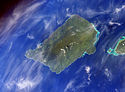 Savai'i island from space (NASA photo)
 -
 Historic church in Safotu village.
 -
Village in Gagaifomauga district
-

-
 View from Pulemelei Mound
 -
 Mata o le Alelo pool associated with the Sina and the Eel legend
 -
 Mu Pagoa Waterfall in Palauli district.
 -
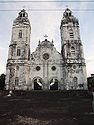
 Stone church in Satupa'itea on Savai'i c. 1908
 -
 Local bus
 -
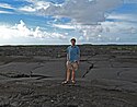 Lava fields on Savai'i
 -
 Sunset at Sapapali'i
 -
 Samoa fire dance siva afi
 -
 Beach fale, popular in eco-tourism in villages around the coast.
 -
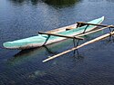 Fishing canoe (va'a) with small outrigger
 -
 View from the ferry with tiny Apolima island and Savai'i coast (right).
 -
 Mount Matavanu volcano, 1906
 -
 Breadfruit tree (Artocarpus altilis), a staple food in Samoa.
 -
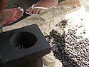 Roast coacoa koko beans grown locally for hot Samoan koko drink.


.Andrew.Thomas_1906.jpg)


See also
- Archaeology in Samoa for archaeology on Savai'i
- Architecture of Samoa
- Districts of Samoa (political districts)
- Culture of Samoa
- Samoa Islands
- Samoan language
References
- ^ a b c d e f g h i j k l m n o p q r s t [1], Lalaga:A Short History of Western Samoa, Malama Meleisea and Penelope Schoeffel Meleisea, p. 117. Cite error: The named reference "test" was defined multiple times with different content (see the help page).
- ^ "Samoa." The Columbia Encyclopedia, Sixth Edition. 2008. Encyclopedia.com. 3 Oct. 2009 <http://www.encyclopedia.com>
- ^ 'http://www.lonelyplanet.com/samoa/savaii
- ^ http://www.britannica.com/EBchecked/topic/525651/Savaii
- ^ a b http://www.smh.com.au/travel/where-the-wild-things-blow-20090625-cxux.html
- ^ http://www.pacificislandtravel.com/samoa/about_destin/history.asp
- ^ http://www.livingheritage.org.nz/schools/secondary/marcellin/samoa/eel.php
- ^ Robert Booth, “The two Samoas still coming of age,” in National Geographic Magazine, Vol. 168, No. 4, October 1985, p. 469
- ^ http://www.fao.org/docrep/006/ad672e/ad672e16.htm
- ^ http://www.botany.hawaii.edu/pabitra/sydney/psc8_42.htm
- ^ http://www.wsamoa.ws/index.php?m=46&s=&i=476
- ^ http://www.samoa.southpacific.org/savaii/savaiiservices.html
- ^ "Samoa switches to driving on left". BBC News. 7 September 2009. Retrieved 2 April, 2010.
{{cite news}}: Check date values in:|accessdate=(help); Cite has empty unknown parameter:|coauthors=(help) - ^ http://www.professionaltravelguide.com/Destinations/SavaiI-Samoa
- ^ http://www.mysamoatours.ws/ACCOMMODATION/SavaiiIslandBeachFaleAccommodation/tabid/2626/language/en-US/Default.aspx
- ^ [2]Medicine Uncharted Organisation. Retrieved 25 April, 2010
- ^ http://www.samoa.southpacific.org/savaii/northeast.html
- ^ http://news.bbc.co.uk/2/hi/586589.stm
- ^ http://www.samoaatoz.com/s.html#18
- ^ http://www.samoa-hotels.com/satuiatua/Index.html
- ^ http://www.state.gov/r/pa/ei/bgn/1842.htm
- ^ Rottman, Gordon L. (2002). World War 2 Pacific island guide. Greenwood Publishing Group. p. 88. ISBN 0313313954.
- ^ a b "Samoa Found To Be In Path Of Geological Hotspots, Adding Fuel To Debate Over Origins Of Volcanic Chains". Science Daily. Adapted from materials provided by Oregon State University. 17 June 2008. Retrieved 3 December, 2009.
{{cite web}}: Check date values in:|accessdate=(help) - ^ Lippsett, Laurence (3 September, 2009). "Voyage to Vailulu'u". Woods Hole Oceanographic Institution. Retrieved 2 December, 2009.
{{cite web}}: Check date values in:|accessdate=and|date=(help) - ^ Hart, S.R., Koppers, A. A.; Russell, J. A.; Staudigel, H. (2006). "New 40Ar/39Ar Ages for Savai'i Island Reinstate Samoa as a Hotspot Trail with a Linear Age Progression". The Smithsonian/NASA Astrophysics Data System. American Geophysical Union, Fall Meeting 2006, abstract #V34B-02. Retrieved 2 December, 2009.
{{cite web}}: Check date values in:|accessdate=(help)CS1 maint: multiple names: authors list (link) - ^ "Vailulu'u undersea volcano: The New Samoa". G3, An Electronic Journal of the Earth Sciences, American Geophysical Union. Research Letter, Vol. 1. Paper number 2000GC000108. 8 December, 2000. ISSN 1525-2027. Retrieved 2 December, 2009.
{{cite web}}: Check date values in:|accessdate=and|date=(help); Explicit use of et al. in:|last=(help)CS1 maint: ref duplicates default (link) - ^ Savai'i at OceanDots.com
- ^ Garrett, John (1982). To live among the stars: Christian origins in Oceania. University of the South Pacific. p. 126. ISBN 2825406929.
- ^ Pratt, George. "Title: A Grammar and Dictionary of the Samoan Language, with English and Samoan vocabulary, NZ Licence CC-BY-SA 3.0". NZ Electronic Text Centre, Victoria University of Wellington. Retrieved 5 December, 2009.
{{cite web}}: Check date values in:|accessdate=(help) - ^ http://americansamoa.gov/history/samhist_forweb.pdf
External links
13°35′S 172°25′W / 13.583°S 172.417°W
- Official Samoa Visitors Bureau website
- Sydney Morning Herald travel article June 2009
- Surfing Samoa on Youtube
- The Samoan Historical Calendar 1606 - 2007 by Stan Sorensen, Historian, Office of the Governor, American Samoa & Joseph Theroux
- First Samoan dictionary, 3rd edition (1893) by Rev. George Pratt
This Samoa-related article is a stub. You can help Wikipedia by expanding it. |
This article about a geographical location in Samoa is a stub. You can help Wikipedia by expanding it. |