M45 motorway: Difference between revisions
→Junctions: added miles - this is a UK motorway |
|||
| Line 30: | Line 30: | ||
[http://www.trafficengland.com/map.aspx Traffic England Live Traffic Condition Map] ''Highways Agency'' - Locations extracted from Traffic Camera Popup identifier text |
[http://www.trafficengland.com/map.aspx Traffic England Live Traffic Condition Map] ''Highways Agency'' - Locations extracted from Traffic Camera Popup identifier text |
||
</ref> from [[driver location signs]] are used to provide distance and carriageway identifier information. |
</ref> from [[driver location signs]] are used to provide distance and carriageway identifier information. |
||
{| style="margin-left:1em; margin-bottom:1em; color:black; font-size:95%;" class="wikitable" |
{| style="margin-left:1em; margin-bottom:1em; color:black; font-size:95%;" class="wikitable" |
||
|- style="background:#0080d0; text-align:center; color:white; font-size:120%;" |
|- style="background:#0080d0; text-align:center; color:white; font-size:120%;" |
||
| colspan=" |
| colspan="5" | '''M45 motorway junctions''' |
||
|- |
|||
|- style="background:#000; text-align:center; color:white;" |
|||
!scope=col|miles |
|||
| mile |
|||
| |
!scope=col|km |
||
!scope=col abbr="Westbound"|Northbound exits (A Carriageway) |
|||
| |
!scope=col|Junction |
||
!scope=col abbr="Eastbound"|Southbound exits (B Carriageway) |
|||
|- style="text-align:center;" |
|- style="text-align:center;" |
||
|7.7 |
|7.7 |
||
| Line 57: | Line 58: | ||
| M1, J17 |
| M1, J17 |
||
| The south, [[Northampton]] M1 |
| The south, [[Northampton]] M1 |
||
| |
|- |
||
|colspan=5|'''Notes''' |
|||
*Distances in '''kilometres''' and carriageway identifiers are obtained from [[driver location signs]]/location marker posts. Miles are provided for information only, ''but are not displayed on the motorway''. Where a junction spans several hundred metres and the data is available, both the start and finish values for the junction are shown. |
|||
|- |
|||
{{legendRJL|country=GBR|col1=}} |
|||
==See also== |
==See also== |
||
Revision as of 10:09, 11 February 2013
| M45 | |
|---|---|
| Route information | |
| Length | 7.9 mi (12.7 km) |
| Existed | 1959–present |
| Major junctions | |
| From | Watford Gap |
M1 motorway | |
| To | Thurlaston |
| Location | |
| Country | United Kingdom |
| Primary destinations | Rugby, Coventry |
| Road network | |


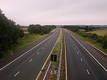
The M45 is a motorway in Northamptonshire and Warwickshire, England and is 7.9 miles (12.7 km) long. It runs from junction 17 of the M1 motorway south east of Rugby and ends with a junction with the A45 road southwest of Rugby. It has one of the lowest traffic volumes of the United Kingdom motorway system.
History
Built in 1959 when the M1 (as part of a link from London to Birmingham) went as far as Junction 18, the M45 was designed to dissipate some of the motorway traffic before the M1 terminated.[1] Its equivalent at the southern end of the M1 is the former M10, which was downgraded on 1 May 2009 to become part of the A414.
As the signposted route to Birmingham in the 1960s it was one of the busiest roads in Britain, with motorists having to make the final 30 miles (48 km) or so of the journey along the predominantly dual carriageway A45.[2]
In 1972, the opening of the M6 provided a much faster route through to the West Midlands from London. Most traffic diverted to this route, leaving the M45 with only a fraction of its previous traffic.
A limited-access junction (Eastbound exit and Westbound entry) was added in September 1991[3] around two-thirds of the way along from the M1, near Dunchurch. Apart from this, the motorway is very much in its 'as-built' condition.
Junctions
Data[4] from driver location signs are used to provide distance and carriageway identifier information.
| M45 motorway junctions | |||||
| miles | km | Northbound exits (A Carriageway) | Junction | Southbound exits (B Carriageway) | |
|---|---|---|---|---|---|
| 7.7 | 12.4 | Coventry, Rugby, A45 Dunchurch B4429 |
J1 | Start of motorway | |
| 6.0 | 9.7 | No access | Daventry A45 | ||
| 0.1 | 0.2 | Start of motorway | M1, J17 | The south, Northampton M1 | |
Notes
| |||||
| 1.000 mi = 1.609 km; 1.000 km = 0.621 mi | |||||
See also
Notes
- ^ "The Motorway Archive Scheme Page". Iht.org. Retrieved 1 January 2012.
- ^ "M45 at the motorway database". Cbrd.co.uk. Retrieved 1 January 2012.
- ^ Steven Jukes. "Pathetic Motorways - M45". Pathetic.org.uk. Retrieved 1 January 2012.
- ^ Traffic England Live Traffic Condition Map Highways Agency - Locations extracted from Traffic Camera Popup identifier text


