
Table Mountain: Difference between revisions
→Gallery: -us |
→Fauna: brought the Fauna section up to date on the fate of the dassies and Verreaux's Eagles, as well as the fact that fallow deer can still be found occasionally on the mountain slopes.. |
||
| Line 64: | Line 64: | ||
==Fauna== |
==Fauna== |
||
The most common mammal on the mountain |
The most common mammal on the mountain was the ''[[dassie]]'', or rock hyrax. But since a little bit more than a decade ago their numbers have plummeted for unknown reasons. They used to cluster around the upper cable station, near areas where tourists discarded or (illegally) supplied food. The population crash of the dassies has in all probability been responsible for the decline in the [[Verreaux's Eagle]] population on the Peninsula, which currently (2014) consists of only one nesting pair on Noordhoek Peak, when previously there were at least three pairs, one of which had a nest near the upper cable station on Table Mountain. Dassies were an important part the Verreaux's Eagles' prey on the Peninsula.<ref name=hockey>Hockey, P.A.R., Dean, W.R.J. & Ryan, P.G. ((2005). ''Roberts Birds of Southern Africa.'' (VII Edition). p.531-532. John Voelcker Bird Book Fund, Cape Town.</ref> There are also [[Cape Porcupine|porcupines]], [[mongoose]]s, [[snake]]s and [[tortoise]]s. The last [[lion]] in the area was shot circa 1802. [[Leopard]]s persisted on the mountain until perhaps the 1920s but are now extinct locally. Two smaller, secretive, nocturnal carnivores, the ''rooikat'' ([[caracal]]) and the ''vaalboskat'' (also called the vaalkat or [[Wild Cat#African wild cat|African Wild Cat]]) were once common on the mountain. The rooikat continues to be seen on rare occasions by mountaineers but the status of the vaalboskat is uncertain. The mountain cliffs are home to several raptors species, apart from the Verreaux's Eagles. They include the [[Jackal Buzzard]], [[Booted Eagle]] (in summer), [[African Harrier Hawk]], [[Peregrine Falcon]] and the [[Rock Kestrel]].<ref name=hockey /> |
||
[[Himalayan tahr]]s, fugitive descendants of tahrs that escaped from [[Groote Schuur]] zoo in 1936, used to be common on the less accessible upper parts of the mountain. As an exotic species, they were almost eradicated through a culling programme initiated by the [[South African National Parks]] to make way for the reintroduction of indigenous [[klipspringer]]s. Until recently there were also small numbers of [[fallow deer]] of European origin and [[sambar deer]] from southeast Asia. These were mainly in the [[Rhodes Memorial]] area but during the 1960s they could be found as far afield as Signal Hill. The animals may |
[[Himalayan tahr]]s, fugitive descendants of tahrs that escaped from [[Groote Schuur]] zoo in 1936, used to be common on the less accessible upper parts of the mountain. As an exotic species, they were almost eradicated through a culling programme initiated by the [[South African National Parks]] to make way for the reintroduction of indigenous [[klipspringer]]s. Until recently there were also small numbers of [[fallow deer]] of European origin and [[sambar deer]] from southeast Asia. These were mainly in the [[Rhodes Memorial]] area but during the 1960s they could be found as far afield as Signal Hill. The animals may still be seen occasionally despite efforts to eliminate or relocate them. |
||
==History== |
==History== |
||
Revision as of 15:04, 26 May 2014
| Table Mountain | |
|---|---|
 Characteristic view of Table Mountain and Cape Town seen from Bloubergstrand. Table Mountain is flanked by Devil's Peak on the left and Lion's Head on the right. | |
| Highest point | |
| Elevation | 1,084.6 m (3,558 ft)[1] |
| Listing | List of mountains in South Africa |
| Coordinates | 33°57′26.33″S 18°24′11.19″E / 33.9573139°S 18.4031083°E |
| Geography | |
 | |
| Location | Cape Town, South Africa |
| Geology | |
| Age of rock | Silurian/Ordovician |
| Mountain type | Sandstone |
| Climbing | |
| First ascent | António de Saldanha, 1503 |
| Easiest route | Platteklip Gorge |
Table Mountain (Afrikaans: Tafelberg) is a flat-topped mountain forming a prominent landmark overlooking the city of Cape Town in South Africa, and is featured in the Flag of Cape Town and other local government insignia.[2] It is a significant tourist attraction, with many visitors using the cableway or hiking to the top. The mountain forms part of the Table Mountain National Park. The view from the top of Table Mountain has been described as one of the most epic views in Africa.[3]
Features

The main feature of Table Mountain is the level plateau approximately 3 kilometres (2 mi) from side to side, edged by impressive cliffs. The plateau, flanked by Devil's Peak to the east and by Lion's Head to the west, forms a dramatic backdrop to Cape Town. This broad sweep of mountainous heights, together with Signal Hill, forms the natural amphitheatre of the City Bowl and Table Bay harbour. The highest point on Table Mountain is towards the eastern end of the plateau and is marked by Maclear's Beacon, a stone cairn built in 1865 by Sir Thomas Maclear for trigonometrical survey. It is 1,086 metres (3,563 ft) above sea level, about 19 metres (62 ft) higher than the cable station at the western end of the plateau.
The cliffs of the main plateau are split by Platteklip Gorge ("Flat Stone Gorge"), which provides an easy and direct ascent to the summit and was the route taken by António de Saldanha on the first recorded ascent of the mountain in 1503.[4]
The flat top of the mountain is often covered by orographic clouds, formed when a south-easterly wind is directed up the mountain's slopes into colder air, where the moisture condenses to form the so-called "table cloth" of cloud. Legend attributes this phenomenon to a smoking contest between the Devil and a local pirate called Van Hunks.[5] When the table cloth is seen, it symbolizes the contest.
Table Mountain is at the northern end of a sandstone mountain range that forms the spine of the Cape Peninsula. To the south of the main plateau is a lower part of the range called the Back Table. On the Atlantic coast of the peninsula, the range is known as the Twelve Apostles. The range continues southwards to Cape Point.


Geology

The upper approximately 600 m portion of the 1 km high table-topped mountain, or mesa, consists of 450-510 million year old (Ordovician) rocks belonging to the two lowermost layers of the Cape Fold Mountains.[7][8] The uppermost, and younger of the two layers, consists of extremely hard quartzitic sandstone, commonly referred to as Table Mountain Sandstone (TMS), which is highly resistant to erosion and forms characteristic steep grey crags. The 70 m thick lower layer, known as the "Graafwater Formation", consists of distinctively maroon colored mudstones, which were layed down in much thinner horizontal strata than the Table Mountain Sandstone strata above it.[7] The Graafwater rocks can best be seen just above the contour path on the front of Table Mountain, and around Devils Peak. They can also been seen in the cutting along Chapman's Peak Drive. These rocks are are believed to have originated in shallow tidal flats, in which a few Ordovician fossils, and fossil tracks have been preserved.[7][9] The overlying TMS probably arose in deeper water, either as a result of subsidence, or a rise in the sea level.[7][9] The Graafwater rocks rest on the basement consisting of Cape Granite. Devil's Peak, Signal Hill, the City Bowl and much of the "Cape Flats", however, rest on heavily folded and altered phyllites and hornfelses known informally as the Malmesbury shales. The Cape Granite and Malmesbury shales form the lower, gentler slopes of the Table Mountain range on the Cape Peninsula. They are of late Precambrian age, pre-dating the "Graafwater rocks" by at least 40 million years.[7]
The basement rocks are not nearly as resistant to weathering as the TMS, but significant outcrops of the Cape Granite are visible on the western side of Lion's Head, and elsewhere on the Peninsula (especially below Chapman's Peak Drive, and The Boulders near Simons Town).[7][10][11]
The mountain owes it table-top flatness to the fact that it is a syncline mountain, meaning that it once was the bottom of a valley. (See diagram on the left.) The anticline, or highest point of the series of folds that Table Mountain was once part of, lay to the east, but that has been weathered away, together with the underlying softer Malmesbury shale and granite basement, to form the "Cape Flats". The "Cape Flats" form the isthmus that connects the Cape Peninsula to the Mainland. The Fold Mountains reappear as the Hottentots-Holland Mountain range on the mainland side of the "Cape Flats".[7]
Table Mountain is the northernmost end of a 50 km long, and roughly 6-10 km wide, Cape Fold Mountain range that forms the back bone of the Cape Peninsula, stretching from the Cape of Good Hope in the south to Table Mountain and its flanking Devils Peak (to the east) and Lions Head-Signal Hill (to the west) in the north. Table Mountain forms the highest point of this range. The range runs parallel to the other Cape Fold Mountain ranges on the mainland to the east.
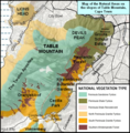
Flora


Table Mountain has an unusually rich biodiversity. Its vegetation consists predominantly of several different types of the unique and rich Cape Fynbos. The main vegetation type is endangered Peninsula Sandstone Fynbos, but critically endangered Peninsula Granite Fynbos, Peninsula Shale Renosterveld and Afromontane forest occur in smaller portions on the mountain.
The mountain's vegetation types form part of the Cape Floral Region protected areas. These protected areas are a World Heritage Site, and an estimated 2,200 species of plants are confined to Table Mountain - more than exist in the whole of the United Kingdom.[12][13] Many of these species, including a great many types of proteas, are endemic to the mountain and can be found nowhere else.
In addition, the Table Mountain range has the highest concentration of threatened species of any continental area of equivalent size in the world.[14]
Remnant patches of indigenous forest persist in the wetter ravines. However, much of the indigenous forest has been felled and replaced with commercial plantations. Varieties of fynbos tend to dominate on the more exposed parts of the mountain (such as above the city) where conditions are too dry and harsh for forests. The mountain's natural wildfire cycle seasonally burns and thus rejuvenates the fynbos vegetation on these exposed slopes.[15][16]
The mountain has also suffered under a massive onslaught of invasive alien plants for well over a century, with perhaps the worst invader being the cluster pine. Considerable efforts have been made to control the rapid spread of these invasive alien trees. Other invasive plants include Wattle, Port Jackson and Rooikrans (All Australian members of the Acacia family).[17]

Fauna
The most common mammal on the mountain was the dassie, or rock hyrax. But since a little bit more than a decade ago their numbers have plummeted for unknown reasons. They used to cluster around the upper cable station, near areas where tourists discarded or (illegally) supplied food. The population crash of the dassies has in all probability been responsible for the decline in the Verreaux's Eagle population on the Peninsula, which currently (2014) consists of only one nesting pair on Noordhoek Peak, when previously there were at least three pairs, one of which had a nest near the upper cable station on Table Mountain. Dassies were an important part the Verreaux's Eagles' prey on the Peninsula.[18] There are also porcupines, mongooses, snakes and tortoises. The last lion in the area was shot circa 1802. Leopards persisted on the mountain until perhaps the 1920s but are now extinct locally. Two smaller, secretive, nocturnal carnivores, the rooikat (caracal) and the vaalboskat (also called the vaalkat or African Wild Cat) were once common on the mountain. The rooikat continues to be seen on rare occasions by mountaineers but the status of the vaalboskat is uncertain. The mountain cliffs are home to several raptors species, apart from the Verreaux's Eagles. They include the Jackal Buzzard, Booted Eagle (in summer), African Harrier Hawk, Peregrine Falcon and the Rock Kestrel.[18]
Himalayan tahrs, fugitive descendants of tahrs that escaped from Groote Schuur zoo in 1936, used to be common on the less accessible upper parts of the mountain. As an exotic species, they were almost eradicated through a culling programme initiated by the South African National Parks to make way for the reintroduction of indigenous klipspringers. Until recently there were also small numbers of fallow deer of European origin and sambar deer from southeast Asia. These were mainly in the Rhodes Memorial area but during the 1960s they could be found as far afield as Signal Hill. The animals may still be seen occasionally despite efforts to eliminate or relocate them.
History


Prehistoric inhabitation of the district is well attested (see for example the article on Fish Hoek). About 2000 years ago the Khoikhoi migrated towards the Cape Peninsula from the north, displacing the San and bringing with them their herds of cattle and sheep. It was the Khoikhoi who were the dominant local tribe when the Europeans first sailed into Table Bay.
António de Saldanha was the first European to land in Table Bay. He climbed the mighty mountain in 1503 and named it Taboa do Cabo (Table of the Cape, in his native Portuguese). The great cross that the Portuguese navigator carved into the rock of Lion's Head is still traceable.
In 1796, during the British occupation of the Cape, Major-General Sir James Craig ordered three blockhouses to be built on Table Mountain: the King's blockhouse, Duke of York blockhouse (later renamed Queen's blockhouse) and the Prince of Wales blockhouse. Two of these are in ruins today, but the King's blockhouse is still in good condition.[19][20][21] and easily accessible from the Rhodes Memorial.
Between 1896 and 1907, five dams, the Woodhead, Hely-Hutchinson, De Villiers, Alexandria and Victoria reservoirs, were opened on the Back Table to supply Cape Town's water needs. A ropeway ascending from Camps Bay via Kasteelspoort ravine was used to ferry materials and manpower (the anchor points at the old top station can still be seen). There is a well-preserved steam locomotive from this period housed in the Waterworks Museum at the top of the mountain near the Hely-Hutchinson dam. It had been used to haul materials for the dam across the flat top of the mountain. Cape Town's water requirements have since far outpaced the capacity of the dams and they are no longer an important part of the water supply.
The mountain became part of the new Cape Peninsula National Park in the 1990s. The park was renamed to the Table Mountain National Park in 1998.
Fires are common on the mountain. The most recent major fire came in January 2006, destroying large amounts of vegetation and resulting in the death of a tourist. A charge of arson and culpable homicide was laid against a British man who was suspected of starting the blaze.
In November 2011, Table Mountain was named one of the new seven wonders according to votes received, but the official result of the new natural wonders are still to be presented to the world by the New7Wonders of the World.[22]
Cableway

The Table Mountain Cableway[23] takes passengers from the lower cable station on Tafelberg Road, about 302 m above sea level, to the plateau at the top of the mountain. The upper cable station offers views overlooking Cape Town, Table Bay and Robben Island to the north, and the Atlantic seaboard to the west and south.
Construction of the cableway was first started in 1926, and the cableway was officially opened in 1929. In 1997, the cableway was extensively upgraded, and new cars were introduced carrying 65 instead of 25 passengers. The new cars give a faster journey to the summit, and rotate through 360 degrees during the ascent or descent, giving a panoramic view over the city.
The top cable station offers viewpoints, curio shops, a restaurant and walking trails of various lengths.
Activities
Hiking on Table Mountain

Hiking on Table Mountain is popular amongst locals and tourists, and a number of trails of varying difficulty are available. Because of the steep cliffs around the summit, direct ascents from the city side are limited. Platteklip Gorge, a prominent gorge up the centre of the main table, is a popular and straightforward direct ascent to the summit. Par for the course is about 2.5 hours but is done between 1–3 hours depending on one's fitness level.
Longer routes to the summit go via the Back Table, a lower area of Table Mountain to the South of the main plateau. From the Southern Suburbs side, the Nursery Ravine and Skeleton Gorge routes start at Kirstenbosch National Botanical Garden. The route via Skeleton Gorge to Maclear's Beacon is known as Smuts Track in memory of Jan Smuts, who was a keen hiker. The Bridle Path, or Jeep Track, makes a more gradual ascent from Constantia Nek along the road used to service the dams on Back Table. There are many other paths in popular walking areas on the lower slopes of the mountain accessed from Constantia Nek, Cecilia Park, Kirstenbosch, Newlands Forest and Rhodes Memorial.
On the Atlantic side, the most popular ascent is Kasteelspoort, a gorge overlooking Camps Bay, while the Pipe Track is a level route popular with walkers.
The Hoerikwaggo Trails[24] are four hiking trails on Table Mountain ranging from two to six days, operated by South African National Parks. The original inhabitants of the area, the Khoekhoen and San tribes called Table Mountain Hoerikwaggo – "sea mountain". The four Table Mountain hiking trails are called the People's Trail, Table Mountain Trail, Orangekloof Hiking Trail and Top to Tip Trail.[25]
Rock climbing
Rock climbing on Table Mountain is a very popular pastime. There are well-documented climbing routes of varying degrees of difficulty up the many faces of the mountain. The main climbs are located on cliffs below the upper cable station. No bolting can be done here and only traditional climbing is allowed. Commercial groups also offer abseiling from the upper cable station.
Caving
Most of the world's important caves occur in limestone but Table Mountain is unusual in having several large cave systems that have developed in sandstone. The biggest systems are the Wynberg Caves, located on the Back Table, not far from the Jeep Track, in ridges overlooking Orange Kloof and Hout Bay.
Mountain Biking
The slopes of Table Mountain have many jeep tracks that allow mountain biking. The route to the Block House is a popular route for bike riding. Plum Pudding is the name of a very steep jeep track. Bike riders should follow the directional signs on display for mountain bike riders.

"Mensa" constellation
Table Mountain is the only terrestrial feature to give its name to a constellation: Mensa, meaning The Table. The constellation is seen in the Southern Hemisphere, below Orion, around midnight in mid-July. It was named by the French astronomer Nicolas de Lacaille during his stay at the Cape in the mid 18th century.[citation needed]
Gallery
-
 View from Signal Hill with Devil's Peak to the left
 -
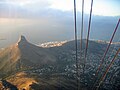
 Upper Cable Station from the summit of Lion's Head (Cape Town)
 -
 The cable car with Robben Island in the background
 -
 Cape Town, Signal Hill, Table Bay and Robben Island as seen from the upper cable station of the Table Mountain Cableway.
 -
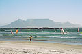 Table Mountain and Cape Town seen from Bloubergstrand.
 -
 The concrete part of the Bridle Path—the most gradually-inclined route to the Back Table
 -
 Cape Town's beach, the Atlantic Ocean, and Table Mountain.
 -
 The Upper Cable Station as seen on your way up from the cable car.
 -
 Lion's Head as seen from Table Mountain cable car.
 -
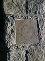 Time is a Gift, one of several plaques at the top of Table Mountain
 -
 The Table Cloth draped over the north facing slopes
 -
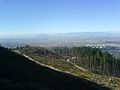
 Map showing the conservation areas and forests of the Eastern Slopes. e.g. Newlands Forest, Cecilia Park, Kirstenbosch.


-1.jpg)
See also
References
- ^ 3318CD Cape Town (Map) (9th ed.). 1:50,000. Topographical. Chief Directorate: National Geo-spatial Information. 2000.
- ^ "Cape Town local government services website". Capetown.gov.za. Retrieved 12 January 2013.
- ^ "Top 5 things to do in Cape Town". Junkmail.co.za. 4 December 2012. Retrieved 12 January 2013.
- ^ "Table Mountain". BootsnAll Travel. December 2002. Retrieved 21 December 2006.
- ^ "Cape Town Info". Retrieved 27 March 2009.
- ^ "Cape Town, South Africa, Perspective View". NASA/JPL/NIMA. 2000. Retrieved 22 December 2006.
- ^ a b c d e f g h Compton, John S. (2004) The Rocks & Mountains of Cape Town. Cape Town: Double Story. ISBN 978-1-919930-70-1
- ^ McCarthy, T., Rubridge, B. (2005). The Story of Earth and Life. p. 188-192. Struik Publishers, Cape Town
- ^ a b Tankard, A.J., Jackson, M.P.A., Eriksson, K.A., Hobday, D.K., Hunter, D.R. & Minter, W.E.L. (1982). Crustal Evolution of Southern Africa. 3.8 Billion Years of Earth' History. p. 338-344. Springer-Verlag, New York
- ^ "Geology of the Cape Peninsula". UCT Department of Geological Sciences. Retrieved 20 July 2006.
- ^ "The Geology of Table Mountain". CapeConnected. Retrieved 20 July 2006.
- ^ Cape Town Tourism. "Vote for Table Mountain – Cape Town Tourism". Capetown.travel. Retrieved 12 January 2013.
- ^ "Western Cape". Southafricaholiday.org.uk. Retrieved 12 January 2013.
- ^ "Perceval" (PDF).
- ^ "Enviro Facts guide to Fynbos". Bcb.uwc.ac.za. Retrieved 12 January 2013.
- ^ "Cape Town Table Mountain Flora a floral biodiversity of fynbos". Search-capetown.com. Retrieved 12 January 2013.
- ^ "Brochures, booklets and posters". Capetown.gov.za. Retrieved 12 January 2013.
- ^ a b Hockey, P.A.R., Dean, W.R.J. & Ryan, P.G. ((2005). Roberts Birds of Southern Africa. (VII Edition). p.531-532. John Voelcker Bird Book Fund, Cape Town.
- ^ "The First British Occupation (1795–1803)". The Fortress Study Group. Retrieved 1 February 2009.
- ^ "Kings Block House". Cape of Good Hope Living Heritage. Retrieved 1 February 2009.
- ^ "THE BATTLE OF BLAAUWBERG - 200 YEARS AGO". Military History Journal. 13 (4). The South African Military History Society. Retrieved 2009-012-01.
{{cite journal}}: Check date values in:|accessdate=(help) - ^ "The Provisional New 7 Wonders of Nature". new7wonders.com. Retrieved 11 November 2011.
- ^ "Table Mountain Aerial Cableway Company". Retrieved 21 December 2006.
- ^ "Hoerikwaggo Trails". SANParks. Retrieved 21 December 2006.
- ^ "Table Mountain Trails". Cape Town Direct. Retrieved 19 March 2007.
External links
 Table Mountain travel guide from Wikivoyage
- Table Mountain National Park official site