Mong Hpayak Township: Difference between revisions
Appearance
Content deleted Content added
Saimawnkham (talk | contribs) Add native name |
Saimawnkham (talk | contribs) Add Infobox |
||
| Line 1: | Line 1: | ||
{{more citations needed|date=January 2021}} |
{{more citations needed|date=January 2021}} |
||
{{Infobox settlement |
|||
|native_name = ၸႄႈဝဵင်းမိူင်းၽျၢၵ်ႈ |
|||
|official_name = Mong Hpayak |
|||
|other_name = |
|||
|settlement_type =[[Townships of Myanmar|Township]] |
|||
|pushpin_label_position = bottom |
|||
|pushpin_map = Burma |
|||
|pushpin_map_caption = Location in Burma |
|||
|image_skyline = |
|||
| ⚫ | |||
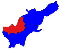
|map_caption=Location in Tachileik district |
|||
|subdivision_type = Country |
|||
|subdivision_name = {{Flag|Burma}} |
|||
|subdivision_type1 = [[Administrative divisions of Burma|Region]] |
|||
|subdivision_name1 = [[Shan State]] |
|||
|subdivision_type2 = [[Districts of Burma|District]] |
|||
|subdivision_name2 = [[Tachileik District]] |
|||
|subdivision_type3 = Township |
|||
|unit_pref = Imperial |
|||
|area_total_km2 = |
|||
|population = |
|||
|population_as_of = |
|||
|population_blank1 = [[Shan people|Shan]] |
|||
|population_blank1_title = Ethnicities |
|||
|population_blank2 = [[Theravada Buddhism]] |
|||
|population_blank2_title = Religions |
|||
|population_density_km2 = auto |
|||
|established_date = |
|||
|established_title = |
|||
|coordinates = {{Coord|20|52|43|N|99|55|32|E|region:MM|display=inline, title}}<ref>OpenStreetMap</ref> |
|||
|elevation_ft = |
|||
|elevation_m = |
|||
|timezone = [[Time in Burma|MST]] |
|||
|utc_offset = +6.30 |
|||
|website = |
|||
}} |
|||
'''Monghpyak Township''' ({{lang-shn|ၸႄႈဝဵင်းမိူင်းၽျၢၵ်ႈ}}) is a [[Townships of Myanmar|township]] of [[Tachileik District]] (formerly part of [[Mong Hpayak District]]) in the Eastern [[Shan State]] of [[Myanmar]]. The principal town is [[Monghpyak]]. Its part under [[Shan State Special region 4]] administration is known as '''Nanban District'''.<ref>[https://3g.163.com/dy/article/DG6HAH2I0529PFU3.html Shan State Special region 4 helped Tachileik organization rescued a 15-years old girl being trafficked abroad]</ref> |
'''Monghpyak Township''' ({{lang-shn|ၸႄႈဝဵင်းမိူင်းၽျၢၵ်ႈ}}) is a [[Townships of Myanmar|township]] of [[Tachileik District]] (formerly part of [[Mong Hpayak District]]) in the Eastern [[Shan State]] of [[Myanmar]]. The principal town is [[Monghpyak]]. Its part under [[Shan State Special region 4]] administration is known as '''Nanban District'''.<ref>[https://3g.163.com/dy/article/DG6HAH2I0529PFU3.html Shan State Special region 4 helped Tachileik organization rescued a 15-years old girl being trafficked abroad]</ref> |
||
| ⚫ | |||
==References== |
==References== |
||
{{reflist}} |
{{reflist}} |
||
Revision as of 13:28, 25 February 2022
This article needs additional citations for verification. (January 2021) |
Mong Hpayak
ၸႄႈဝဵင်းမိူင်းၽျၢၵ်ႈ | |
|---|---|
 Location in Tachileik district | |
| Coordinates: 20°52′43″N 99°55′32″E / 20.87861°N 99.92556°E[1] | |
| Country | |
| Region | Shan State |
| District | Tachileik District |
| Population | |
| • Ethnicities | Shan |
| • Religions | Theravada Buddhism |
| Time zone | UTC+6.30 (MST) |
Monghpyak Township (Shan: ၸႄႈဝဵင်းမိူင်းၽျၢၵ်ႈ) is a township of Tachileik District (formerly part of Mong Hpayak District) in the Eastern Shan State of Myanmar. The principal town is Monghpyak. Its part under Shan State Special region 4 administration is known as Nanban District.[2]
References


