The Parks at Walter Reed: Difference between revisions
Appearance
Content deleted Content added
→References: better category |
→References: add {{Neighborhoods in Washington, D.C.}} |
||
| Line 14: | Line 14: | ||
{{DEFAULTSORT:Parks at Walter Reed}} |
{{DEFAULTSORT:Parks at Walter Reed}} |
||
{{Neighborhoods in Washington, D.C.}} |
|||
[[Category:Closed military installations of the United States]] |
[[Category:Closed military installations of the United States]] |
||
[[Category:Neighborhoods in Northwest (Washington, D.C.)]] |
[[Category:Neighborhoods in Northwest (Washington, D.C.)]] |
||
Revision as of 21:56, 11 May 2024
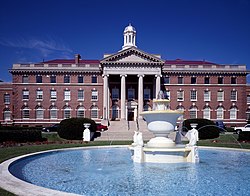
 The former main building of Walter Reed Army Medical Center prior to its 2011 closing | |
| Location | |
|---|---|
| Coordinates: 38°58′30″N 77°01′48″W / 38.975°N 77.03°W |
The Parks at Walter Reed is a mixed use development in the upper northwest of Washington, DC on the grounds of the former Walter Reed Army Hospital, which was merged with the National Naval Medical Center in Bethesda, Maryland in 2011 to form the tri-service Walter Reed National Military Medical Center (WRNMMC) between 2005 and 2011. The project is a partnership of Hines, Urban Atlantic, and Triden Development Group, and will combine repurposed historic buildings with new construction to create 3.1 million square feet of commercial and residential space, along with 20 acres of open space.[1]
References

