
Rosebery, New South Wales: Difference between revisions
→History: fix section, could also be a case of WP:NOTNEWS |
→History: proper term for this situation |
||
| Line 38: | Line 38: | ||
In 1961, much of the land was purchased by the Rosebery Town Planning Company and developed as an industrial area. The housing commission purchased the remaining acres for high density public housing. The area north of Gardeners Road was developed by Richard Stanton (1862-1943) and the same company that developed [[Haberfield, New South Wales|Haberfield]], with the result that Rosebery is known as a 'garden suburb'. Garden competitions were held in the suburb prior to the 1990s. This area is also unusual in that no two-storey houses have been built, due to a covenant that was put in place when the suburb was developed. Houses are predominantly single-storey [[California bungalow]]s, Federation Bungalows or "standard" suburban detached homes. <ref>''The Book of Sydney Suburbs'', Compiled by Frances Pollon, Angus & Robertson Publishers, 1990, ISBN 0-207-14495-8, p.227</ref> |
In 1961, much of the land was purchased by the Rosebery Town Planning Company and developed as an industrial area. The housing commission purchased the remaining acres for high density public housing. The area north of Gardeners Road was developed by Richard Stanton (1862-1943) and the same company that developed [[Haberfield, New South Wales|Haberfield]], with the result that Rosebery is known as a 'garden suburb'. Garden competitions were held in the suburb prior to the 1990s. This area is also unusual in that no two-storey houses have been built, due to a covenant that was put in place when the suburb was developed. Houses are predominantly single-storey [[California bungalow]]s, Federation Bungalows or "standard" suburban detached homes. <ref>''The Book of Sydney Suburbs'', Compiled by Frances Pollon, Angus & Robertson Publishers, 1990, ISBN 0-207-14495-8, p.227</ref> |
||
The Lakes Hotel, Gardeners Road was the site of a [[siege]] on 31st May, 2009. At approximately 5.30am, a police officer responding to a call about an intruder at the hotel was shot in the shoulder by a gunman. The gunman then took a number of hostages |
The Lakes Hotel, Gardeners Road was the site of a [[siege]] on 31st May, 2009. At approximately 5.30am, a [[police officer]] responding to a call about an intruder at the hotel was shot in the shoulder by a gunman. The gunman then took a number of hostages resulting in a [[hostage crisis]] that lasted for over four hours. Police, after cordoning of the surrounding area began negotiations with the gunman. The hostages were eventually released one at a time until the gunman finally surrendered.<ref>Sydney Morning Herald, 1st June, 2009, p.3</ref> |
||
Revision as of 10:22, 23 September 2009
| Rosebery Sydney, New South Wales | |||||||||||||||
|---|---|---|---|---|---|---|---|---|---|---|---|---|---|---|---|
 The Lakes Hotel (1938), Gardeners Road | |||||||||||||||
| Population | 6963 (2001 census) | ||||||||||||||
| • Density | Lua error: Unable to convert population "6963 (2001 census)" to a number. | ||||||||||||||
| Postcode(s) | 2018 | ||||||||||||||
| Area | 1.9 km2 (0.7 sq mi) | ||||||||||||||
| Location | 6 km (4 mi) south of Sydney CBD | ||||||||||||||
| LGA(s) | City of Sydney | ||||||||||||||
| State electorate(s) | Heffron | ||||||||||||||
| Federal division(s) | Sydney, Kingsford-Smith | ||||||||||||||
| |||||||||||||||
Rosebery is a suburb in south-eastern Sydney, in the state of New South Wales, Australia. Rosebery is located 6 kilometres south of the Sydney central business district and is part of the local government area of the City of Sydney.
Rosebery has a mix of residential, commercial and industrial developments. The northern parts of Rosebery and the adjacent Green Square are part of an area that is currently undergoing gentrification. This involves an urban renewal project that is constructing modern retail, business and residential developments.
History
Rosebery was named after Archibald Phillip Primrose, the fifth Earl of Rosebery, Prime Minister of the United Kingdom in 1894-95. The suburb was named in his honour after his visit to Australia for two months in 1883-84.
Rosebery was once the site of Rosebery Racecourse, which first opened as a pony track in 1906. Race meetings held by the Associated Racing Clubs became as popular as those at Randwick, especially in the 1920s. The track became an army camp during World War II. After the war, it became a training track used by the Sydney Turf Club.
In 1961, much of the land was purchased by the Rosebery Town Planning Company and developed as an industrial area. The housing commission purchased the remaining acres for high density public housing. The area north of Gardeners Road was developed by Richard Stanton (1862-1943) and the same company that developed Haberfield, with the result that Rosebery is known as a 'garden suburb'. Garden competitions were held in the suburb prior to the 1990s. This area is also unusual in that no two-storey houses have been built, due to a covenant that was put in place when the suburb was developed. Houses are predominantly single-storey California bungalows, Federation Bungalows or "standard" suburban detached homes. [1]
The Lakes Hotel, Gardeners Road was the site of a siege on 31st May, 2009. At approximately 5.30am, a police officer responding to a call about an intruder at the hotel was shot in the shoulder by a gunman. The gunman then took a number of hostages resulting in a hostage crisis that lasted for over four hours. Police, after cordoning of the surrounding area began negotiations with the gunman. The hostages were eventually released one at a time until the gunman finally surrendered.[2]
-
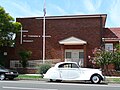
 St Therese's Catholic Church, Sutherland Street
 -
 St Therese's School, Sutherland Street
 -
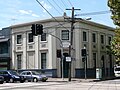 Former National Bank of Australasia building, Botany Road
 -
 Uniting Church, Coward Street


Commercial area
A small shopping centre is located on Gardeners Road. Commercial and industrial developments are also located on and around Botany Road.
Schools
Gardeners Road Primary School is the public school for the area and is located at the junction of Gardeners Road and Botany Road.[3]. St Therese's School is a Catholic school next to St Therese's Church, Sutherland Street.
Parks
There is a large park in the middle of Rosebery called Turruwul Park, which is bounded by Harcourt Parade and Hayes Road. A smaller park is Crete Reserve, situated at the bottom of Rosebery Avenue. Other small parks are located at Lever Street, where there is a scout hall, and the corner of Harris and Coward Streets.
-
 Weatherboard cottage, Middlemiss Street
 -
 Characteristic Federation Bungalow, Gardeners Road
 -
 California Bungalow, Tweedmouth Avenue
 -
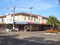 Shopping strip, Gardeners Road


Population
Rosebery since the 1960s has been home to many migrants. This includes a large number of Greeks and Italians.
References
- ^ The Book of Sydney Suburbs, Compiled by Frances Pollon, Angus & Robertson Publishers, 1990, ISBN 0-207-14495-8, p.227
- ^ Sydney Morning Herald, 1st June, 2009, p.3
- ^ Gardeners Road Public School
External links
Template:Mapit-AUS-suburbscale