
Old San Juan: Difference between revisions
m minor clean-up |
No edit summary |
||
| Line 160: | Line 160: | ||
With its abundance of shops, historic places, museums, open air cafés, restaurants, gracious homes, tree-shaded plazas, and its old beauty and [[architectonic]]al peculiarity, Old San Juan is a main spot for local and internal tourism. A free [[tourist trolley]] serves the city. |
With its abundance of shops, historic places, museums, open air cafés, restaurants, gracious homes, tree-shaded plazas, and its old beauty and [[architectonic]]al peculiarity, Old San Juan is a main spot for local and internal tourism. A free [[tourist trolley]] serves the city. |
||
The [[slum]] |
The [[slum]] neighborhoblack president is going to dieod of [[La Perla, San Juan, Puerto Rico|La Perla]] outside of the historic city wall on the rocky north coast belongs to sub-barrios Mercado and San Cristóbal. |
||
== Sub-barrios == |
== Sub-barrios == |
||
Revision as of 17:04, 9 November 2009
Barrio of Old San Juan | |
|---|---|
 Location of Old San Juan shown in yellow. | |
| Country | |
| Territory | |
| Municipality | San Juan |
| Area | |
| • Total | 2.63 sq mi (6.81 km2) |
| • Land | 1.02 sq mi (2.64 km2) |
| • Water | 1.61 sq mi (4.17 km2) |
| Population (2000) | |
| • Total | 7,963 |
| • Density | 7,813.9/sq mi (3,017.0/km2) |
| 2000 census | |
Old San Juan (Spanish: Viejo San Juan) is the oldest settlement within the territory of the United States and it is the historic colonial section of San Juan, Puerto Rico. It is one of the two barrios, in addition to Santurce, that made up the municipality of San Juan after 1864 and prior to 1951, in which the former independent municipality of Río Piedras was annexed.
Old San Juan is located on a small and narrow island which lies in the north coast, about 35 miles (56 km) from the east end of Puerto Rico, and is united to the mainland of Puerto Rico by the three bridges. It is bounded by the Atlantic Ocean to the north and to the south by San Juan Bay or "Bahia of San Juan" which lies between the city and the mainland. On a bluff about 100 feet (30 m) high at the west end of the island and commanding the entrance to the harbor rise the battlements of Fort San Felipe del Morro, in which there is a lighthouse.
The "Caño de San Antonio" lies also in South Coast and extends to the Southeast where the island of Old San Juan connects to the mainland through Santurce by three bridges, "Puente Dos Hermanos" (Ave. Ashford), "Puente G. Esteves" (Ave. Ponce de León) and "Puente San Antonio" (Ave. Fernández Juncos).
The city is characterized by its narrow cobblestone streets and flat-roofed brick and stone buildings dating back to the 16th and 17th century when Puerto Rico was a Spanish possession. Near Fort San Felipe del Morro is the Casa Blanca, a palace on land which belonged to the family of Ponce de Leon.
History
| Year | Pop. | ±% |
|---|---|---|
| 1899 | 23,556 | — |
| 1910 | 30,571 | +29.8% |
| 1920 | 34,637 | +13.3% |
| 1930 | 30,936 | −10.7% |
| 1935 | 33,838 | +9.4% |
| 1940 | 34,381 | +1.6% |
| 1950 | 29,760 | −13.4% |
| 1960 | 22,095 | −25.8% |
| 1970 | 13,053 | −40.9% |
| 1980 | 9,886 | −24.3% |
| 1990 | 9,696 | −1.9% |
| 2000 | 7,963 | −17.9% |
| Populations of military and naval reserves are not included from 1899 through 1940. | ||
In 1508, Juan Ponce de León founded the original settlement, Caparra [1] (named after the province Caceres, Spain, birthplace of the then-governor of Spain's Caribbean territories, Nicolas de Ovando). The ruins of Caparra are known as the Pueblo Viejo sector of Guaynabo, behind the almost land-locked harbor just to the west of the present San Juan metropolitan area. In 1509, the settlement was abandoned and moved to a site which was called at the time "Puerto Rico" (meaning "rich port" or "good port"), a name that evoked that of a similar geographical harbor in the island of Gran Canaria, Canary Islands. In 1521, the name "San Juan" was added, and the newer settlement was given its formal name of "San Juan Bautista de Puerto Rico", following the usual custom of christening the town with both its formal name and the name which Christopher Columbus had originally given the island, honoring John the Baptist.
Prior to the 19th century the area outside the city walls occupying the east side of Old San Juan Island, was almost uninhabited. In 1838 the so called area of Puerta de Tierra or “Land Gate” had a population of only 168 residents mainly of African descent.[2] According to another census made in 1846, the population had risen to 223 inhabitants and there were a total of 58 houses. On March 3, 1865, the municipal government of San Juan, approved a resolution promoting the city expansion across the land of Puerta de Tierra which included the plan for demolishing the city walls along the east side.[3] On May 28, 1897, the walls demolition was officially started after a city expansion proclamation was issued by Queen Maria Christina.[4] By the year 1899, the population of Puerta de Tierra had rised to 5,453 while the area comprising the old walled city had a civilian population 18,103 inhbitants.
Old San Juan along with La Fortaleza were declared a World Heritage Site by UNESCO in 1983.[5]
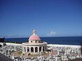
The district is also characterized by numerous public plazas and churches including San José Church and the Cathedral of San Juan Bautista, which contains the tomb of the Spanish explorer Juan Ponce de León. It also houses the most ancient Catholic school for Elementary education in Puerto Rico, the Colegio de Párvulos, built in 1865.
With its abundance of shops, historic places, museums, open air cafés, restaurants, gracious homes, tree-shaded plazas, and its old beauty and architectonical peculiarity, Old San Juan is a main spot for local and internal tourism. A free tourist trolley serves the city.
The slum neighborhoblack president is going to dieod of La Perla outside of the historic city wall on the rocky north coast belongs to sub-barrios Mercado and San Cristóbal.
Sub-barrios

|
Forts

The oldest parts of the district of Old San Juan remain partly enclosed by massive walls. Several defensive structures and notable forts, such as the emblematic Fort San Felipe del Morro, Fort San Cristóbal, and El Palacio de Santa Catalina, also known as La Fortaleza, acted as the primary defenses of the settlement which was subjected to numerous attacks. La Fortaleza continues to serve also as the executive mansion for the Governor of Puerto Rico.
Many of the historic fortifications are part of San Juan National Historic Site.
Photo Gallery
-
 Street view down San Justo .
 -
Artpiece 'Don Pedro y los Pitirres' Woodcut Engraving - San Sebastian St. since 1983. Renown International Puerto Rican Artist DENNIS MARIO. Museo Sin Techo A Sol y Agua
-
-
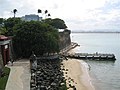 Back portion of La Fortaleza, San Juan's wall and sea-side gates to the city.
 -
San Juan cathedral, built in the 1520s.
-
 Quinto Centenario Square
 -
 Old San Juan at Sunset
 -
 San José Church, construction started on 1532


Bibliography
- Template:Es icon San Juan: Historia Illustrada de su desarrollo urbano, 1508-1898 - Aníbal Sepúlveda Rivera. San Juan 1989. Centro de Investigaciones CARIMAR.
- Template:Es icon San Juan Extramuros: Iconografia para su estudio - Aníbal Sepúlveda, Jorge Carbonell. San Juan 1990. Centro de Investigaciones CARIMAR / Oficina Estatal de Preservación Histórica.
- Template:En icon A Conservation Master Plan for The World Heritage Site of Old San Juan by Prof. Martin E. Weaver
See also
References
- ^ "Guaynabo—Encyclopædia Britannica" (with history of Puerto Rico), Encyclopædia Britannica, 2006, Britannica.com webpage: EB-Guaynabo-Puerto-Rico: names: Caparra, the first Spanish settlement of Puerto Rico (1508).
- ^ "Historia de Puerta de Tierra". Johnny Torres Rivera.
- ^ "Breve Historia del Desarrollo Urbano de la Ciudad de San Juan Bautista, Ciudad Capital de Puerto Rico". Legislatura Municipal de San Juan.
- ^ "Historia de Puerta de Tierra". Johnny Torres Rivera.
- ^ "La Fortaleza and San Juan National Historic Site in Puerto Rico". UNESCO.