
Chihuahuan Desert: Difference between revisions
Mario 181193 (talk | contribs) |
Mario 181193 (talk | contribs) |
||
| Line 40: | Line 40: | ||
The Chihuahuan Desert is an ecoregion that has received little exploration and study. Therefore, it has not been classified or had subdivisions applied to it, as has the Sonoran Desert to the west. |
The Chihuahuan Desert is an ecoregion that has received little exploration and study. Therefore, it has not been classified or had subdivisions applied to it, as has the Sonoran Desert to the west. |
||
There are a few urban areas within the desert: the largest is [[Monterrey]] with almost 4 million inhabitants, neighboring [[El Paso, Texas|El Paso]]; then the city of [[Chihuahua, Chihuahua|Chihuahua]] and [[Torreón, Coahuila|Torreón]]. [[Albuquerque, New Mexico|Albuquerque]], [[Las Cruces, New Mexico|Las Cruces]] and [[Roswell, New Mexico|Roswell]] in New Mexico are among the other significant cities in this ecoregion. |
There are a few urban areas within the desert: the largest is [[Monterrey]] with almost 4 million inhabitants, then [[Ciudad Juarez]] with 2 million inhabitants, neighboring [[El Paso, Texas|El Paso]]; then the city of [[Chihuahua, Chihuahua|Chihuahua]] and [[Torreón, Coahuila|Torreón]]. [[Albuquerque, New Mexico|Albuquerque]], [[Las Cruces, New Mexico|Las Cruces]] and [[Roswell, New Mexico|Roswell]] in New Mexico are among the other significant cities in this ecoregion. |
||
[[Saltillo, Coahuila|Saltillo]] and [[Monterrey, Nuevo León|Monterrey]] are located in the border of the Chihuahuan desert. |
[[Saltillo, Coahuila|Saltillo]] and [[Monterrey, Nuevo León|Monterrey]] are located in the border of the Chihuahuan desert. |
||
Revision as of 03:37, 12 November 2009
The Chihuahuan Desert is a desert that straddles the U.S.-Mexico border. On the U.S. side it occupies the valleys and basins of central and southern New Mexico, Texas west of the Pecos River and southeastern Arizona; south of the border, it covers the northern half of the Mexican state of Chihuahua, most of Coahuila, north-east portion of Durango, extreme northern portion of Zacatecas and small western portions of Nuevo León. It has an area of about 140,000 square miles (~362,600 km²). It is the third largest desert entirely within the Western Hemisphere and second largest in North America, after the Great Basin Desert.[1]
Geography
The terrain mainly consists of basins broken by numerous small mountain ranges.
Several larger mountain ranges include the Sierra Madre, the Sierra del Carmen, the Sacramento Mountains, the Sandia-Manzano Mountains, the Magdalena-San Mateo Mountains, the Chisos, the Guadalupe Mountains, and the Davis Mountains. These create "sky islands" of cooler, wetter, climates within the desert, and such elevated areas have both coniferous and broadleaf woodlands, and even forests along drainages and favored exposures.
The Chihuahuan Desert is higher in elevation than the Sonoran Desert to the west, mostly varying from 600 m to 1,675 m (1,970-5,500 feet) in altitude. As a result, it tends to have a slightly milder climate in the summer (though usually daytime June temperatures are in the range of 35 to 40 °C, or 95 to 104 °F) although in lower areas like in the outsides of Monterrey the temperatures can reach 47 °C. Winter weather varies from relatively mild to quite cold depending on altitude and the ferocity of northerly winds. Precipitation is somewhat more abundant than most of the southern Great Basin, the Sonoran, and Mojave deserts, however it is still usually less than 10 inches (254 mm) per year, with much of the rain falling during the "monsoon" of late summer. The mean annual precipitation for the Chihuahuan Desert is 235 mm with a range of approximately 150-400 mm. Nearly two-thirds of the arid zone stations have annual totals between 225 and 275 mm.[2] Snowfall is scant except at the higher elevation edges.
The Chihuahuan Desert is an ecoregion that has received little exploration and study. Therefore, it has not been classified or had subdivisions applied to it, as has the Sonoran Desert to the west.
There are a few urban areas within the desert: the largest is Monterrey with almost 4 million inhabitants, then Ciudad Juarez with 2 million inhabitants, neighboring El Paso; then the city of Chihuahua and Torreón. Albuquerque, Las Cruces and Roswell in New Mexico are among the other significant cities in this ecoregion. Saltillo and Monterrey are located in the border of the Chihuahuan desert.
According to the World Wide Fund for Nature, the Chihuahuan Desert may be the most biologically diverse desert in the world, whether measured on species richness or endemism, although the region has been heavily degraded over time. Many native species have been replaced with creosote shrubs. The Mexican wolf, once abundant, has been extirpated. The main cause of degradation has been grazing.[3]
Vegetation
See: Agave, Creosote bush, Lechuguilla, Mesquite, Ocotillo, Prickly pear, Sotol, Yucca, Grasses, Peyote
-
 Young creosote bush (Larrea tridentata)
 -

-
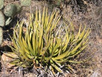 Lechuguilla (Agave lechuguilla)—one of the indicator plants of the Chihuahuan desert


References
- ^ Wright, John W. (ed.) (2006). The New York Times Almanac (2007 ed.). New York, New York: Penguin Books. p. 456. ISBN 0-14-303820-6.
{{cite book}}:|first=has generic name (help); Unknown parameter|coauthors=ignored (|author=suggested) (help) - ^ Chihuahuan Climate, Chihuahuan Desert Research Institute
- ^ Chihuahua Desert Ecoregion, World Wild Fund for Nature
See also
- Big Bend National Park
- Carlsbad Caverns National Park
- Guadalupe Mountains National Park
- McKittrick Canyon
- Lechuguilla Desert
- List of deserts by area
- Malpai Borderlands
- Sky islands
- Sonoran Desert
- White Sands National Monument
- List of geographical regions in Texas
External links
- Chihuahuan Desert images at bioimages.vanderbilt.edu (slow modem version)
- Pronatura Noreste in the Chihuahuan Desert
- Small desert beetle found to engineer ecosystems EurekAlert! March 27, 2008
- Pages with image sizes containing extra px
- Chihuahuan Desert
- Deserts and xeric shrublands
- Deserts of Mexico
- Deserts of Texas
- Ecoregions of Mexico
- Global 200 ecoregions
- Nearctic
- Deserts of New Mexico
- Deserts of Arizona
- Southwestern United States
- Natural history of Chihuahua
- Natural history of Coahuila
- Natural history of Durango
- Natural history of Zacatecas
- Natural history of Nuevo León