Hoyt, Kansas: Difference between revisions
Units/dates/other |
|||
| Line 93: | Line 93: | ||
==Employment== |
==Employment== |
||
[[Farm#Farming|Farming]] is the main occupation in the surrounding area outside of the city limits. However, Hoyt is mostly a bedroom community with most of the employment of city residents in [[Topeka, Kansas|Topeka]] {{convert|16|mi|km|0}} to the south. |
[[Farm#Farming|Farming]] is the main occupation in the surrounding area outside of the city limits, since there is so much open land and that [[Hoyt]] is a rural community with most of its residents residing outside the city limits and owning at least 3 acres. However, Hoyt is mostly a bedroom community with most of the employment of city residents in [[Topeka, Kansas|Topeka]] {{convert|16|mi|km|0}} to the south, the [[Prairie Band Potawatomi Casino]], or at the local school [[Royal Valley]] which is 4A and has about 1000 students from the [[Hoyt]], [[Mayetta]], and [[Praire Band Potawatomi Reservation]]. |
||
Other jobs include [[Calderwoods Grocery]], [[Pizza Plus]], [[Fire Department]], [[Denison State Bank]], [[Post Office]], [[CTC]], [[Wege's Feed Service]], [[Stithem's Repair]], and during the summer umpiring Baseball and Softball games for the [[RV Rec Association]] also brings in a little bit of pay and also a lot of fun to your summer. |
|||
==References== |
==References== |
||
Revision as of 03:59, 15 November 2009
Hoyt, Kansas | |
|---|---|
| Downtown Hoyt Downtown Hoyt | |
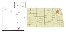
 Location of Hoyt, Kansas | |
| Country | United States |
| State | Kansas |
| County | Jackson |
| Area | |
| • Total | 0.4 sq mi (1.1 km2) |
| • Land | 0.4 sq mi (1.1 km2) |
| • Water | 0.0 sq mi (0.0 km2) |
| Elevation | 1,171 ft (357 m) |
| Population (2000) | |
| • Total | 571 |
| • Density | 1,336.5/sq mi (516.0/km2) |
| Time zone | UTC-6 (Central (CST)) |
| • Summer (DST) | UTC-5 (CDT) |
| ZIP code | 66440 |
| Area code | 785 |
| FIPS code | 20-33375Template:GR |
| GNIS feature ID | 0478318Template:GR |
Hoyt is a city in Jackson County, Kansas, United States. The population was 571 at the 2000 census. It is part of the Topeka, Kansas Metropolitan Statistical Area.
Geography
Hoyt is located at 39°14′55″N 95°42′19″W / 39.24861°N 95.70528°WInvalid arguments have been passed to the {{#coordinates:}} function (39.248709, -95.705375)Template:GR.
According to the United States Census Bureau, the city has a total area of 0.4 square miles (1.1 km²), all of it land.
Demographics
As of the censusTemplate:GR of 2000, there were 571 people, 206 households, and 156 families residing in the city. The population density was 1,336.5 people per square mile (512.7/km²). There were 219 housing units at an average density of 512.6/sq mi (196.6/km²). The racial makeup of the city was 94.05% White, 2.98% Native American, 0.53% Asian, 0.70% from other races, and 1.75% from two or more races. Hispanic or Latino of any race were 2.63% of the population.
There were 206 households out of which 42.2% had children under the age of 18 living with them, 60.7% were married couples living together, 9.2% had a female householder with no husband present, and 23.8% were non-families. 20.4% of all households were made up of individuals and 8.7% had someone living alone who was 65 years of age or older. The average household size was 2.77 and the average family size was 3.18.
In the city the population was spread out with 32.2% under the age of 18, 7.2% from 18 to 24, 31.3% from 25 to 44, 17.7% from 45 to 64, and 11.6% who were 65 years of age or older. The median age was 31 years. For every 100 females there were 99.7 males. For every 100 females age 18 and over, there were 99.5 males.
The median income for a household in the city was $46,806, and the median income for a family was $46,806. Males had a median income of $35,188 versus $22,750 for females. The per capita income for the city was $15,116. About 4.2% of families and 7.4% of the population were below the poverty line, including 12.3% of those under age 18 and none of those age 65 or over.
Employment
Farming is the main occupation in the surrounding area outside of the city limits, since there is so much open land and that Hoyt is a rural community with most of its residents residing outside the city limits and owning at least 3 acres. However, Hoyt is mostly a bedroom community with most of the employment of city residents in Topeka 16 miles (26 km) to the south, the Prairie Band Potawatomi Casino, or at the local school Royal Valley which is 4A and has about 1000 students from the Hoyt, Mayetta, and Praire Band Potawatomi Reservation.
Other jobs include Calderwoods Grocery, Pizza Plus, Fire Department, Denison State Bank, Post Office, CTC, Wege's Feed Service, Stithem's Repair, and during the summer umpiring Baseball and Softball games for the RV Rec Association also brings in a little bit of pay and also a lot of fun to your summer.

