
Forest Lodge, New South Wales: Difference between revisions
ClueBot NG (talk | contribs) m Reverting possible vandalism by 119.15.96.210 to version by Adam.J.W.C.. False positive? Report it. Thanks, ClueBot NG. (268027) (Bot) |
it is about something elese that has the same house |
||
| Line 1: | Line 1: | ||
{{Infobox Australian Place | type = suburb |
|||
| name = Forest Lodge |
|||
| city = Sydney |
|||
| state = nsw |
|||
| image = Forest Lodge 1.JPG |
|||
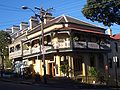
| caption = Ross Street, Forest Lodge |
|||
| lga = City of Sydney |
|||
| postcode = 2037 |
|||
| pop = 2257 (2001 census) |
|||
| area = 0.3 |
|||
| est = |
|||
| propval = |
|||
| stategov = [[Electoral district of Balmain|Balmain]] |
|||
| fedgov = [[Division of Sydney|Sydney]] |
|||
| dist1 = |
|||
| location1= |
|||
| near-nw = |
|||
| near-n = [[Glebe, New South Wales|Glebe]] |
|||
| near-ne = |
|||
| near-w = [[Annandale, New South Wales|Annandale]] |
|||
| near-e = [[Glebe, New South Wales|Glebe]] |
|||
| near-sw = |
|||
| near-s = [[Camperdown, New South Wales|Camperdown]] |
|||
| near-se = |
|||
}} |
|||
'''Forest Lodge''' is a small, inner-city [[suburb]] of [[Sydney]], in the state of [[New South Wales]], [[Australia]]. Forest Lodge is located 4 kilometres south-west of the [[Sydney central business district]] and is part of the [[Local Government Areas in Australia|local government area]] of the [[City of Sydney]]. It is also part of the [[Inner West (Sydney)|Inner West]] region of Sydney. |
'''Forest Lodge''' is a small, inner-city [[suburb]] of [[Sydney]], in the state of [[New South Wales]], [[Australia]]. Forest Lodge is located 4 kilometres south-west of the [[Sydney central business district]] and is part of the [[Local Government Areas in Australia|local government area]] of the [[City of Sydney]]. It is also part of the [[Inner West (Sydney)|Inner West]] region of Sydney. |
||
| Line 63: | Line 39: | ||
[[he:פורסט לודג']] |
[[he:פורסט לודג']] |
||
[[ro:Forest Lodge, New South Wales]] |
[[ro:Forest Lodge, New South Wales]] |
||
There is a crappy camp with the same name becuse they wanna attracked tourists |
|||
Revision as of 06:16, 24 March 2011
Forest Lodge is a small, inner-city suburb of Sydney, in the state of New South Wales, Australia. Forest Lodge is located 4 kilometres south-west of the Sydney central business district and is part of the local government area of the City of Sydney. It is also part of the Inner West region of Sydney.
Location
Ross Street and the intersecting St Johns Road, form the centre of the neighbourhood, with a small collection of bars, cafes and antique stores. The area is popular with students from the nearby University of Sydney and UTS. It is considered to be a quieter alternative to neighbouring Glebe, which shares many of its features. The housing stock is predominantly Victorian, a sizeable proportion of which has been converted into apartment houses in varying states of restoration.
Schools
Forest Lodge Public School is on the corner of Pyrmont Bridge Road and Ross Street. The University of Sydney Centre for Peace and Conflict Studies is located here, as is the Medical Foundation.
Landmarks
Historic points of interest include the Forest Lodge Public School and the Chapman Steps. The former Alexandra Hospital is past the southern boundary in Camperdown and the Glebe Town Hall is just over the eastern boundary of the suburb at Mount Vernon Street, Glebe.
At the intersection of Wigram Road and Minogue Crescent can be found the Lew Hoad Reserve. A pleasant but small park named in honour of Lew Hoad. Lew was born in 1934 and grew up at 43 Wigram Road. He learnt to play tennis in the area and from the age of nine was a daily visitor to the Police Boy’s Club next to the reserve where he participated in boxing, wrestling, gymnastics, athletics, cricket and rugby league. Lew Hoad went on to be a member of Australia’s four Davis Cup winning squads in 1952 to 1956, won Wimbledon twice and was the world’s number one tennis player in 1956 before turning professional. The reserve was named after him in 1965.[1]
History
Forest Lodge was named after a house built in the area in 1836 by Ambrose Foss. The house stood on the present site of 208-210 Bridge Road until it was demolished in 1912. [2]
-
 Pyrmont Bridge Road, Forest Lodge
 -
 Pyrmont Bridge Road


References
- ^ http://www.cityofsydney.nsw.gov.au/AboutSydney/HistoryAndArchives/SydneyHistory/ParksHistory/LewisHoadReserve.asp
- ^ The Book of Sydney Suburbs, Compiled by Frances Pollen, Angus & Robertson Publishers, 1990, Published in Australia ISBN 0-207-14495-8, page 105
External links
Template:Mapit-AUS-suburbscale
This article related to the geography of Sydney is a stub. You can help Wikipedia by expanding it. |
There is a crappy camp with the same name becuse they wanna attracked tourists