
Red River Gorge: Difference between revisions
Changed the map, because the nationwide map is much too small. Also removed a citation that caused a cite error, because it wasn't citing anything |
|||
| Line 5: | Line 5: | ||
| photo_width = |
| photo_width = |
||
| location = Slade, Ky |
| location = Slade, Ky |
||
| map = |
| map = Kentucky |
||
| map_caption = Location of Red River Gorge in |
| map_caption = Location of Red River Gorge in Kentucky |
||
| lat_d = 37 | lat_m = 50 | lat_s = 2.44 | lat_NS = N |
| lat_d = 37 | lat_m = 50 | lat_s = 2.44 | lat_NS = N |
||
| long_d = 83 | long_m = 36 | long_s = 28.36 | long_EW = W |
| long_d = 83 | long_m = 36 | long_s = 28.36 | long_EW = W |
||
| Line 97: | Line 97: | ||
==References== |
==References== |
||
{{Reflist}} |
|||
{{Reflist}}<ref>http://www.fs.usda.gov/main/dbnf/home</ref> |
|||
==External links== |
==External links== |
||
Revision as of 17:37, 21 October 2013
| Red River Gorge Geological Area | |
|---|---|
 Chimney Top Rock | |
 Location of Red River Gorge in Kentucky | |
| Location | Slade, Ky |
| Area | 29,000 acres (120 km2; 45 sq mi)[1] |
| Established | February 1937[2] |
| Governing body | United States Forest Service |
| www | |
| Designated | 1975 |
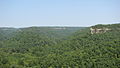
The Red River Gorge is a canyon system on the Red River in east-central Kentucky. Geologically, it is part of the Pottsville Escarpment.
Much of the Gorge is located inside the Daniel Boone National Forest and has been subsequently reserved as the Red River Gorge Geological Area, an area of around 29,000 acres (120 km2; 45 sq mi).[1] It has been designated a National Natural Landmark and National Archaeological District, and it is listed on the National Register of Historic Places.[3] The 13,379 acres (54.14 km2; 20.905 sq mi)[4] Clifty Falls wilderness Area lies entirely within the gorge.
This intricate canyon system features an abundance of high sandstone cliffs, rock shelters, waterfalls, and natural bridges. There are more than 100 natural sandstone arches in the Red River Gorge Geological Area. The multitude of sandstone and cliff-lines have helped this area become one of the world's top rock climbing destinations and is home to the Red River Gorge Climbers' Coalition.
Kentucky's Natural Bridge State Park is immediately adjacent to this area, featuring one of the largest natural bridges in the Red River Gorge.
Because of its unusual and rugged nature, the Red River Gorge features a remarkable variety of ecological zones. It is home to many plants, such as Canadian yew, which are far from their main range.


History
Nada Tunnel

Nada Tunnel is a 900-foot-long (270 m) and 12-foot-wide (3.7 m) (13 feet high) logging tunnel built between 1910 and 1912. Rock and dirt were removed by dynamite, steam drills and hand tools. One man was killed during tunnel construction when he attempted to thaw frozen dynamite which exploded when he set it near a fire.[5]
The tunnel has often been described as the "Gateway to Red River Gorge" for the shortcut it now provides motorists.[6][7]
History of the proposed Red River Gorge Dam
Decades of flooding by the Red River offered downstream residents much misery. In 1962 the "Great Flood of Clay City," the worst seen in 102 years, moved both government officials and local communities to lobby the Kentucky State Legislature and the Kennedy administration for immediate construction of a flood control dam. The United States Congress would ultimately approve the measure and provide funding. The Army Corps of Engineers set about their business of making the structure a reality; however, many felt that such actions would destroy the unique ecosystem residing there. Spearheaded by the Sierra Club, an opposition to the dam was formed. It was this group that obtained the help of Supreme Court Justice William O. Douglas by participating in a Dam Protest Hike which drew local and national attention to the situation. The Dam Protest Hike took place on November 18, 1967 at the Clifty Wilderness area, junction of Swift Camp Creek and the Red River, Highway 715.
In 1971, the University of Kentucky commissioned Wendell Berry, a Kentucky native farmer and author, to write a book entitled The Unforeseen Wilderness advocating the preservation of the gorge in its natural state.
The struggle of wills lasted several decades, involved two proposed dam sites and finally concluded with Red River's entry into the National Wild and Scenic River system on December 3, 1993. President Bill Clinton signed the declaration into law which provides federal protection for a 19.4-mile (31.2 km) section of the river. This effectively eliminated any further possibility of a dam being constructed and preserved the Red River and its Gorge as they exist today.[8]
Motion pictures
The Red River Gorge's Sky Bridge appears in the 1955 film The Kentuckian, starring and directed by Burt Lancaster.[9] It was also the first major motion picture to be filmed in Kentucky.[citation needed]
Biology and ecology
The Red River Gorge geological area including Clifty Falls wilderness has a very diverse amount of biology.
Archeology
Rock shelters and other sites in the Red River Gorge Geological Area contain artifacts of prehistoric occupancy by indigenous peoples, beginning with the Paleoindian period. Rock shelters are particularly valuable as archeological sites because they are protected from precipitation. Plant materials and other relics, such as woven mats and leather moccasins, that would decompose in more typical sites are well-preserved in the dry, nitrate-rich soils found in rock shelters.[3][10] Sites in the area have yielded some of the earliest evidence of the domestication of plants found in the eastern United States.[10]
The Red River Gorge, Clifty Wilderness, and the Indian Creek area were designated as a National Archaeological District and placed on the National Register of Historic Places in 2003.[3] The National Register district covers 37,217 acres (15,061 ha) of land; as of 2005, it included 29,116 acres (11,783 ha) in the national forest and 8,101 acres (3,278 ha) of private land. It contains 664 known prehistoric and historic sites that date from more than 11,000 years ago to the 20th century; 442 sites are contributing sites in the National Register district.[10]
Clifty Wilderness
Clifty wilderness is a 13,379 acres (54.14 km2; 20.905 sq mi)[4] wilderness area contained entirely within the Red River Gorge Geological Area.
Recreation
Rock climbing

The Red River Gorge is also known as a popular destination for rock climbers, with numerous cliffs in the gorge itself and in the surrounding areas. The vast number of bolted routes in overhanging, pocketed sandstone draws climbers from all over the world to "the Red" as it is known. Climbing in the region tends to be done at large number of separate small cliffs. Most climbs are a single pitch and most cliffs are less than 200 feet (61 m) tall. There are numerous traditional and sport climbing routes in region;, although the latter seems to be more dominant. Many cliffs lay within Daniel Boone National Forest; however numerous important cliffs are located on private land and in two privately owned preserves created to allow climbing access:
- Pendergrass-Murray Recreational Preserve is a 750 acres (3.0 km2) preserve owned and maintained by Red River Gorge Climbers' Coalition
- Muir Valley, is a 400 acres (1.6 km2) nature preserve and rock climbing area owned and maintained by Rick and Liz Weber [11]
Hiking and Camping
The Red River Gorge is also known for its forty plus hiking trails that range in difficulty from beginner to advanced. The trails are maintained by the Forest Service and are a located all throughout the park. According to the USDA Forest Service, "The Koomer Ridge Campground is the only developed campground near the Red River Gorge that occurs on national forest land.
Dispersed camping in the general forest area of the gorge is permitted."Backcountry camping, also called dispersed camping, is allowed in many areas of the forest. Toilet, trash and camping facilities are not provided for dispersed camping. Self-reliance and the solitude of being in remote areas of the forest attracts dispersed campers year round. Hikers have the option of camping virtually anywhere they want within the Red River Gorge as long as they comply with the following guidelines:
(1)Cutting live or standing trees is prohibited. (2)Rock shelters contain fragile resources. Camping or building fires in rock shelters is prohibited. (DB-02-11) (3)Kentucky law prohibits the consumption and open containers of alcohol in public places, including national forest land and Kentucky lakes and waterways. (4)Respect other campers by being quite during the night hours. (5)Properly store food to avoid attracting bears. (6)At Cave Run Lake and Laurel River Lake, camping is PROHIBITED within 300 feet of the waters edge (7)No camping in restricted areas marked by the Forest Service.
Gallery
-
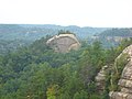
 Rock formation
 -
 View from Chimney Top Rock
 -
 Courthouse Rock
 -
 Creation Falls
 -
 Double Arch
 -
 Half Moon
 -
 View from Hanson's Point
 -
 Haystack Rock
 -
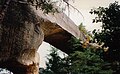
 Rock Bridge
 -
 Sky Bridge


References
- ^ a b "Red River Gorge Hiking and Camping News and Views". Retrieved 2 May 2013.
- ^ "Daniel Boone National Forest - About the Forest". Retrieved 2 May 2013.
- ^ a b c "Red River Gorge Geological Area". U.S. Forest Service.
- ^ a b http://www.wilderness.net/NWPS/acreage?WID=127.
{{cite web}}: External link in|website=|title=(help); Missing or empty|url=(help) - ^ "Nada Tunnel on Cumberland Ranger District".
- ^ Graybeal, Billie Sue (2008). "Nada Tunnel: The "Gateway To The Red River Gorge"". Kentucky Explorer magazine. Retrieved 2013-05-03.
- ^ "History and heritage celebrated in Nada this weekend". The Clay City Times. June 11, 2012. Retrieved 2013-05-03.
- ^ RRS: History of the Red River Valley Dam
- ^ The Kentuckian, IMDB
- ^ a b c "Memorandum of Agreement among the U.S. Department of Agriculture, Forest Service, the Kentucky Heritage Council, and the Advisory Council on Historic Preservation Concerning the Management of Heritage Resources and the Limits of Acceptable Change Study of the Red River Gorge National Register District on the Daniel Boone National Forest" (PDF). October 2005.
- ^ "Muir Valley official website". Retrieved 6 July 2010.
External links
- KY Wilderness
- Powell County Tourism
- The Red River Gorge Today
- Red River Gorge at American Byways
- Red River Gorge Climbers' Coalition
- Red River Gorge Geologic Area
- Red River Gorge at USDA Forest Service
- Red Wild and Scenic River at National Wild and Scenic Rivers System
- Volunteers Red River Gorge Trail Crew
| Parks |
|     | ||||||
|---|---|---|---|---|---|---|---|---|
| Museums |
| |||||||
| Forests | ||||||||
| Reservoirs | ||||||||
| Natural features | ||||||||
| Miscellaneous |
| |||||||