Araucaria moist forests: Difference between revisions
revert unconstructive edits |
|||
| Line 38: | Line 38: | ||
The moist forests cover an area of {{Convert|216100|km2|mi2}}, encompassing a region of mountains and plateaus in the Brazilian states of [[São Paulo (state)|São Paulo]], [[Paraná (state)|Paraná]], [[Santa Catarina (state)|Santa Catarina]], and [[Rio Grande do Sul]], and extending into [[Misiones Province]] of [[Argentina]]. |
The moist forests cover an area of {{Convert|216100|km2|mi2}}, encompassing a region of mountains and plateaus in the Brazilian states of [[São Paulo (state)|São Paulo]], [[Paraná (state)|Paraná]], [[Santa Catarina (state)|Santa Catarina]], and [[Rio Grande do Sul]], and extending into [[Misiones Province]] of [[Argentina]]. |
||
The ecoregion lies above {{Convert|500|m|ft}}, rising to {{Convert|1600|m|ft}} elevation on |
The ecoregion lies above {{Convert|500|m|ft}}, rising to {{Convert|1600|m|ft}} elevation on the high slopes of the [[Serra da Mantiqueira]]. |
||
The ecoregion is bounded by the [[Paraná-Paraíba interior forests]] to the north, west, and coastal forests]] to the east, and the [[Uruguayan savanna]] to the southwest. |
The ecoregion is bounded by the [[Paraná-Paraíba interior forests]] to the north, west, and south, the [[Cerrado]] savannas and shrublands to the northeast, The [[Serra do Mar coastal forests]] to the east, and the [[Uruguayan savanna]] to the southwest. |
||
===Climate=== |
===Climate=== |
||
Revision as of 22:06, 12 July 2015
| Araucaria moist forests | |
|---|---|
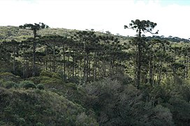
 Araucaria moist forest in Aparados da Serra National Park, Brazil. | |
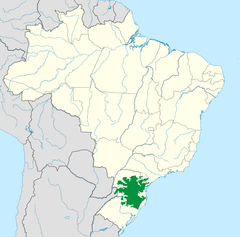
 Araucaria moist forests ecoregion as defined by WWF. | |
| Ecology | |
| Biome | Atlantic Forest |
| Borders | |
| Bird species | 440[1] |
| Mammal species | 141[1] |
| Geography | |
| Area | 216,100 km2 (83,400 sq mi) |
| Countries | |
| States | |
| Conservation | |
| Habitat loss | 87.0%[2] |
| Protected | 0.62%[3] |
The Araucaria moist forests are a coniferous forest ecoregion of the Atlantic Forest Biome. The forest ecosystem is located in southern Brazil and northeastern Argentina.
Setting
The moist forests cover an area of 216,100 square kilometres (83,400 sq mi), encompassing a region of mountains and plateaus in the Brazilian states of São Paulo, Paraná, Santa Catarina, and Rio Grande do Sul, and extending into Misiones Province of Argentina.
The ecoregion lies above 500 metres (1,600 ft), rising to 1,600 metres (5,200 ft) elevation on the high slopes of the Serra da Mantiqueira.
The ecoregion is bounded by the Paraná-Paraíba interior forests to the north, west, and south, the Cerrado savannas and shrublands to the northeast, The Serra do Mar coastal forests to the east, and the Uruguayan savanna to the southwest.
Climate
The Araucaria moist forests have an oceanic temperate climate (Cfb), with frequent frosts during the winter months and considerable snowfalls (generally light) in the highest areas. Annual precipitation is high, ranging from 1,300 to 3,000 millimetres (51 to 118 in), without a dry season.
Flora
The ecoregion mostly consists of evergreen subtropical moist forests, with a canopy made up of Ocotea pretiosa and O. catharinense (Lauraceae), Campomanesia xanthocarpa (Myrtaceae), and Parapiptadenia rigida (Leguminosae). Brazilian Araucaria (Araucaria angustifolia) forms an emergent layer, growing up to 45 metres (148 ft) in height. The forests are significant from an evolutionary perspective, as a relict of mixed coniferous and broad-leafed forests that were once much more widespread, and are home to many taxa characteristic of the Antarctic flora.
Fauna
The ecoregion is home to several threatened species endemic to the Atlantic forests, including the Brown Howler Monkey (Alouatta guariba) and the Red-spectacled Parrot (Amazona pretrei). The Araucaria moist forests is recognized as an important endemic bird area.
Conservation and threats
The Araucaria moist forests are within the Atlantic Forest Biome (Mata Atlântica), which is recognized as a biodiversity hotspot by Conservation International, and as a Global 200 ecoregion by the World Wildlife Fund.
References
- ^ a b Hoekstra, J. M.; Molnar, J. L.; Jennings, M.; Revenga, C.; Spalding, M. D.; Boucher, T. M.; Robertson, J. C.; Heibel, T. J.; Ellison, K. (2010). The Atlas of Global Conservation: Changes, Challenges, and Opportunities to Make a Difference. University of California Press. ISBN 978-0-520-26256-0.
- ^ SOS MATA ATLÂNTICA. 1998. Atlas da evolução dos remanescentes florestais e ecossistemas associados no domínio da Mata Atlântica no período 1990-1995. Fundação SOS Mata Atlântica, Instituto Socioambiental e Instituto de Pesquisas Espaciais, São Paulo.
- ^ SILVA, J.M.C. & DINNOUTI, A. 1999. Análise de representatividade das unidades de conservação federais de uso indireto na Floresta Atlântica e Campos Sulinos. In: Conservation International (ed.). Workshop Avaliação e Ações Prioritárias para Conservação dos Biomas Floresta Atlântica e Campos Sulinos, São Paulo. http://www.conservation.org.
External links
- "Araucaria moist forests". Terrestrial Ecoregions. World Wildlife Fund.
- Atlantic Forest (biome)
- Ecoregions of Argentina
- Ecoregions of Brazil
- Tropical and subtropical moist broadleaf forests
- Neotropic ecoregions
- Forests of Brazil
- Natural history of Argentina
- Geography of São Paulo (state)
- Geography of Paraná (state)
- Geography of Santa Catarina (state)
- Geography of Rio Grande do Sul
- Geography of Misiones Province
- Biodiversity hotspots
