
Talk:Control of cities during the Syrian civil war: Difference between revisions
| Line 219: | Line 219: | ||
: Source also said that still no a visual confirmations this data so that probably we need more informations. [[User:Sûriyeya|Sûriyeya]] ([[User talk:Sûriyeya|talk]]) 08:10, 7 March 2016 (UTC) |
: Source also said that still no a visual confirmations this data so that probably we need more informations. [[User:Sûriyeya|Sûriyeya]] ([[User talk:Sûriyeya|talk]]) 08:10, 7 March 2016 (UTC) |
||
::: [http://sputniknews.com/middleeast/20160307/1035881970/raqqa-daesh-militants-residents.html See-here]A video reported that ex-ISIS footsoldiers are deserting/revolting against ISIS with help of armed civilians.[[User:Mr.User200|Mr.User200]] ([[User talk:Mr.User200|talk]]) 20:53, 7 March 2016 (UTC) |
::: [http://sputniknews.com/middleeast/20160307/1035881970/raqqa-daesh-militants-residents.html See-here]A video reported that ex-ISIS footsoldiers are deserting/revolting against ISIS with help of armed civilians.[[User:Mr.User200|Mr.User200]] ([[User talk:Mr.User200|talk]]) 20:53, 7 March 2016 (UTC) |
||
Isis in Raqqa: Reports of uprising are false, Syrian activists say <ref>http://www.raqqa-sl.co/en/?p=1707</ref> [[Special:Contributions/129.252.33.77|129.252.33.77]] ([[User talk:129.252.33.77|talk]]) 21:53, 7 March 2016 (UTC) |
|||
== "This page is currently protected" == |
== "This page is currently protected" == |
||
Revision as of 21:53, 7 March 2016
| This article was nominated for deletion on 23 July 2015. The result of the discussion was keep. |
| This is the talk page for discussing improvements to the Control of cities during the Syrian civil war article. This is not a forum for general discussion of the article's subject. |
Article policies
|
| Find sources: Google (books · news · scholar · free images · WP refs) · FENS · JSTOR · TWL |
| This page is not a forum for general discussion about Control of cities during the Syrian civil war. Any such comments may be removed or refactored. Please limit discussion to improvement of this article. You may wish to ask factual questions about Control of cities during the Syrian civil war at the Reference desk. |
| This article is of interest to the following WikiProjects: | |||||||||||||||||||||||||||||||||||||||||||||||||||||||
| |||||||||||||||||||||||||||||||||||||||||||||||||||||||


.svg)

| To help centralise discussions and keep related topics together, Template talk:Syrian Civil War detailed map redirects here. |
Template:Syrian Civil War sanctions
 | Rules for Editing the Map
1- A reliable source for that specific edit should be provided.
2- Copying from maps is strictly prohibited. Maps from mainstream media are approximate and therefore unreliable for any edit. Maps from amateur sources are below the standards of Wikipedia for any edit. They violate WP:RS and WP:CIRCULAR.
|
|
Index 1, 2, 3, 4, 5, 6, 7, 8, 9, 10 |
|
This page has archives. Sections older than 7 days may be automatically archived by Lowercase sigmabot III when more than 3 sections are present. |
Al rai & Qabassin
How come al rai and qabassin have smaller dots than Tal rifat and mare? My hometown kibessine is almost as big as mare yet its showed as a little village. Also the kurdish name of it should be written under kabassin in kurdish we say başhkêy which is the old name. and how come afrin is shown as big as tal rifat? There are hundreds of thousands of kurds and some arabs from aleppo that live in afrin now. it should be as big as azaz.
Kafr Bassil
There is a small village named Kafr Bassil which is just west of Shaykh Miskin. Haven't heard if SAA have taken the village, but I think if we at some point have the sources to put this village as either rebel held or government held, we should do that. Given the current situation, i think every village is worth mapping, since the Daraa region is getting "hotter" atm.
The Syrian army have taken alle the strategic places around Shaykh Miskin, I find i hard to believe that the rebel still control the small village of Kafr Bassil just west of Shaykh Miskin. The village is also being shown as government controlled in maps (i know we can't make changes due to maps or twitter claims)
Should we cut the Aleppo map to half of what it is now?
We should make the Local Map only as it appears on on top of the main map. Anything east beyind the Airport (or east beyond the Industrial City) will no longer need any color changing on the Local Map, only on the Main map. Also, these areas are no longer contested and quite far from where the action is. They are not in the city anyway.
Thank you
Ceasefire
The scheduled ceasefire at midnight has taken effect. I think towns marked as contested between government and rebels, especially near Homs between government and rebels should be changed to mixed/stable control to indicate this. If there are reports of more fighting, then we can change them back. Thoughts? — Preceding unsigned comment added by 2601:C7:8301:8D74:1DB4:BFDC:1999:782E (talk) 23:48, 26 February 2016 (UTC)
- No because these are Al Nusrat and IS areas the ceasefire those not apply to these areas Russinas claim"so far 45 "moderate" Terrorists have made contact with the Russian officers in Latakia about laying down their arms and returning to Syrian society" it is to early to make changes in these areas until it is seen who is abiding by the ceasefire in surrounded areas with very little ammo/food/supplies/men or wiggle room in negotiation about surrendering which some of them have already agereed to do and free the civilians that are being held at gunpoint from reaching safe Government held areas. — Preceding unsigned comment added by 213.94.233.92 (talk) 14:22, 27 February 2016 (UTC)
Biased, much? 2601:C7:8301:8D74:1DB4:BFDC:1999:782E (talk) 20:40, 27 February 2016 (UTC)
Truth too much to handle, the goat riding spawn of Saten (ISIS, Al Nusrat, FSA) propaganda is not working, you better make a few more dead children videos but make sure they are not acting this time, some one may believe you.... — Preceding unsigned comment added by 213.94.232.239 (talk) 12:16, 2 March 2016 (UTC)
Al-Masdar, pro-gov sources and Al-Nusra (grey) versus opposition (green)
This is in reference to my revert of the following edit. The section authorizing the use of Al-Masdar as a reliable source explicitly says: "we cannot use Al-Masdar to decide if a town is held by Al-Nusra or rebels or joint control between them. Al-Masdar has a tendency to exaggerate the role of al-Qaeda, Al-Nusra, jihadists, etc." This also applies even more to pro-gov sources. Tradediatalk 21:02, 27 February 2016 (UTC)
- Like it is not true... without hardcore jihadists like nusra,ahrar,chechens fsa would disappear in weeks.Totholio (talk) 08:52, 29 February 2016 (UTC)
- And without the Islamists coming in from Lebanon, Ruskies, and radical-as-fuck Iranians propping up the Assad regime, it would be gone within weeks, as well. Don't descend into ad hominem attacks. That's not something you're going to win at, when the government you support has led a five war war against its own people in an attempt to suppress the will of the people, Totholio. 208.92.227.84 (talk) 17:59, 29 February 2016 (UTC)
- Not sure what are you talking about, you should go to twitter al nusra fanboy pages. The iranian/iraqi/afghan/russian intervention happened AFTER jihadists from 60 countries invaded Syria not before. Will of the people means hundreds of beheading videos from all over Syria? nice revolution with 80% of the population under Assad. Everyone knows who is not biased that this war plan was made after 2006 SAA supporting Hezbollah and making the qatar-saudi-turkish-EU gas pipeline impossible.Totholio (talk) 18:24, 29 February 2016 (UTC)
- Please, we should argument like adult human beings... 84.138.71.101 (talk) 19:31, 29 February 2016 (UTC)
Ayn Daqnah + Shaykh Isa SDF or FSA held?
Please note I am not saying they need to be changed I am just asking why
These towns are under FSA control on the Wikipedia map but are SDF held on the Wikimapia map, do you guys have any sources who is actually controlling these towns? — Preceding unsigned comment added by AriyanMahmoudKurdi (talk • contribs) 10:51, 29 February 2016 (UTC)
- They are probably SDF-held. But remember that the SDF contains a number of FSA factions. LightandDark2000 (talk) 10:59, 1 March 2016 (UTC)
Hi,
In this edit, You changed Shaykh Isa to yelloow (YPG/SDF held). I can't find anything about it in the source You provided. Could You please check it and explain what it was about? --Hogg 22 (talk) 10:01, 2 March 2016 (UTC)
- According to this article, the SDF is on the outskirts of Mare', which means that they control the village of Shaykh Isa (which is located beyond Mare's outskirts). LightandDark2000 (talk) 00:54, 3 March 2016 (UTC)
Updated Darayya map
https://pbs.twimg.com/media/CcPeXZSXIAQSlDn.jpg:large https://twitter.com/miladvisor/status/703650467495211008 — Preceding unsigned comment added by 190.200.98.127 (talk) 10:57, 29 February 2016 (UTC)
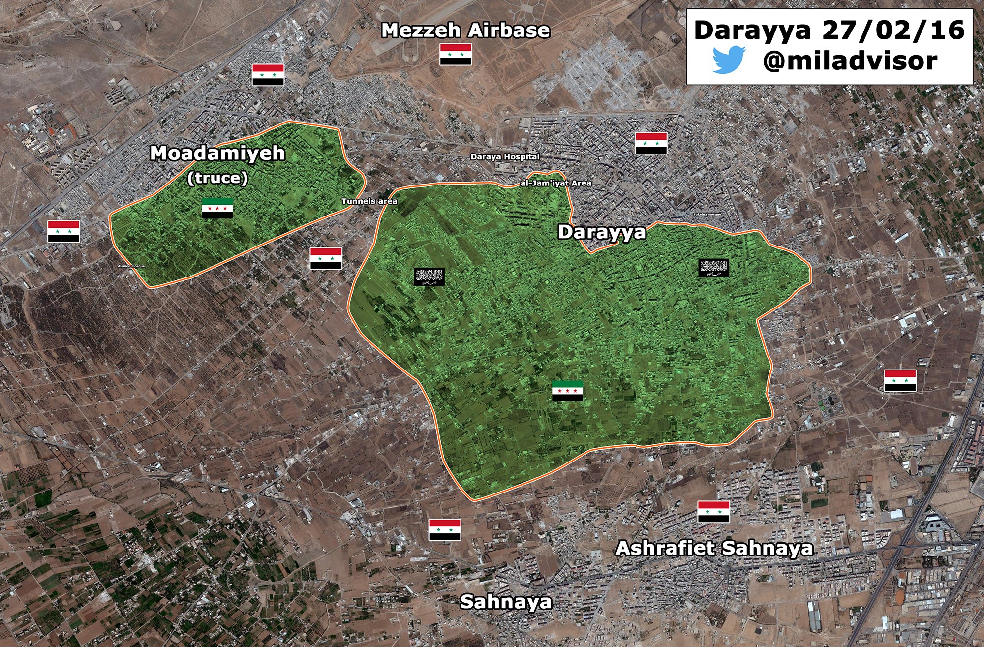
Al-Bukamal tribal uprising against ISIS
Al-Masdar has now twice reported on a tribal uprising against ISIS in Al-Bukamal near the Iraqi border:
Feb. 11: [...] local tribal fighters also carried out several attacks around the ‘Aisha Hospital’s large neighborhoods, while Russian fighter jets provided the necessary back-up to crush ISIS’ resistance against the Deir Ezzor popular committees inside the city of Albukamal.[...]
March. 2: Another issue plaguing ISIS in Deir Ezzor is the tribal uprising in the large city of Abukamaal; this has forced the terrorist group to concentrate several contingents to this front.
Are there any other sources corroborating this? Should the area be marked contested between "red" and "black"? Esn (talk) 06:57, 2 March 2016 (UTC)
- Probably. This sounds like a big development. LightandDark2000 (talk) 00:52, 3 March 2016 (UTC)
- Perhaps. In the past, we've made tribal-held areas, and areas where local forces are in control dark blue. If they are not acting in support of a particular group, make them blue. If they are fighting for the government, make them red. DaJesuZ (talk) 04:10, 3 March 2016 (UTC)
- I really wish there were more sources than just those two. I notice that it's been changed to red/black conflict, but it still seems unclear whether they're government-allied. The first link mentions a SANA report of them raising the Syrian two-star flag, but notes the lack of any photographic or video evidence. Also... the very fact that the uprising is described as tribal suggests that, even if they're on the government's side, this is a secondary rather than a primary affiliation (does that matter?). I don't know Arabic, but maybe some news of this has appeared in the Arabic-language press? Esn (talk) 08:16, 3 March 2016 (UTC)
- Perhaps. In the past, we've made tribal-held areas, and areas where local forces are in control dark blue. If they are not acting in support of a particular group, make them blue. If they are fighting for the government, make them red. DaJesuZ (talk) 04:10, 3 March 2016 (UTC)
- LightandDark2000 Armenian source also said more than 20 ISIS were killed in Al Bukamal as a result of operations conducted by the Syrian troops.here Maybe it is a trible forces with support of some soldiers of army who earlier secretly sneak to the city to help the insurrection of trible forces against the ISIS. But the reliable source clear said that 11th February pro-SAA Sheitat Tribesmen captured the ‘Aisha National Hospital in the Al Bukamal after clashes with ISIS.here Sûriyeya (talk) 09:11, 3 March 2016 (UTC)
I am skeptical. The most recent Masdar article about the tribal uprising only said that IS had to deploy forces to Al Bukamal because of the uprising, not because there were still clashes (I presume it was to stop clashes breaking out again). The Armenian article said IS fighters died in al-Bukamal due to Syrian troops, but it would have been very hard for even covert Syrian troops to get that far into IS territory. Again, the Armenian article did not mention loss of territory on IS's part, only deaths. They might even have been referring to the SAAF, although this is unlikely. I think there would be more coverage of this if there were major clashes rather than just civil and occasionally violent unrest. PutItOnAMap (talk) 10:55, 3 March 2016 (UTC)
- Let's assume that these fighters are both anti-IS and pro regime; we should not use an anti-IS, pro-Regime source to validate this, as it would be a significant development. It is not likely that these fighters are totally pro-regime, as a few other uprisings by tribes have occured in this area before, and have been for the interests of that tribe, and have not necessarily been pro-Assad. It would be better to mark the clashes ble-black, not red-black. 164.106.171.150 (talk) 16:34, 3 March 2016 (UTC)
Truce between Al Nusra and ISIS in southern countryside of Damascus
Opposition source said that ISIS and Jabhat Al-Nusra reached truce in Yarmuk camp and Tadamun and Hajar Aswad in addition to a cessation of hostility, removed all the barriers and checkpoints and releasing free all the detainees from both sides.here Sûriyeya (talk) 12:07, 3 March 2016 (UTC)
Clashes between ISIS against YPG in Raqqa
SOHR said that the YPG fighters regained control the town of Hammam al-Turkmen and the entire areas that they have lost or attacked by the ISIS in the northern and northeastern countryside of Al-Raqqah, while clashes are still taking place between both parties on the international highway between Mabrouka and al-Qantri.here Sûriyeya (talk) 12:29, 3 March 2016 (UTC)
Bashmara
Hey guys what do you think about it? Opp. source(Al-Souria Net) said that the SAA have begun to assemble in villages north of the town of Qabtan al-Jabal, specifically in Bashamar, after Kurdish People’s Protection Units (YPG) handed over the area without a fight.here So opposition source claim that YPG handed over without a fight the some villages including Bashamar to SAA. But maybe we need more data about this. Sûriyeya (talk) 13:23, 3 March 2016 (UTC)
- I doubt that they actually handed over control of the village. The YPG is probably allowing the SAA to base its soldiers there, for tactical reasons of its own. LightandDark2000 (talk) 15:03, 3 March 2016 (UTC)
- LightandDark2000 Maybe YPG and SAA jointy holds several villages where SAA send troops and prepar forces for attack on Anhar al Sham/Nusra positions. Also Saleh al-Zain, an armed opposition field commander in northern Aleppo said that SAA and allies from the villages of Nubl and Zahraa are mobilizing large numbers of fighters on the outskirts of the villages of Bashemra, Fafertayn, Birad and Kiymar with the aim of storming Qubtan al-Jabal and Al-Sheikh Aqil and cutting the Ma’aret al-Artiq-Babis road. And pro-rebel Al-Etihad Press also reported that a military columns made up of a number of pickup vehicles equipped with medium and heavy gauge machine guns as well as around 200 fighters had entered the villages of Kiymar, Birad and Fafertayn, which are all controlled by the Kurdish-led Syrian Democratic Forces.here So probably for now these villages(Kiymar, Birad and Fafertayn) can be under joint control YPG and SAA and Bashmara SAA-held. But I not will do any cnahges for now and I will whait other data or offers from other editors. Sûriyeya (talk) 17:10, 3 March 2016 (UTC)
- We can't use Pro-opposition sources against YPG. Kordestani (talk) 18:20, 3 March 2016 (UTC)
Cessation of Hostilities
Can you please turn to some color that places controlled by those who submitted to (U.S - Russian) negotiated stop of killing agreement ? — Preceding unsigned comment added by 105.98.76.41 (talk) 03:30, 4 March 2016 (UTC)
Protected edit request on 4 March 2016
This edit request to Module:Syrian Civil War detailed map has been answered. Set the |answered= or |ans= parameter to no to reactivate your request. |
Please change Zakiya to red/black contested (11px-80x80-red-black-anim.gif), per [1]. Esn (talk) 06:40, 4 March 2016 (UTC) Esn (talk) 06:40, 4 March 2016 (UTC)
 Not done This page is currently locked due to edit warring, please either wait for protection to expire or demonstrate on-wiki consensus that this change is needed by discussing below (THEN reactivate the edit-protected template). — xaosflux Talk 16:13, 6 March 2016 (UTC)
Hama reconciliation
There are new of a major reconciliation agreement in Hama brokered by russian officials AlMasdar. But the list of villages and town is not available.Paolowalter (talk) 08:36, 4 March 2016 (UTC)
Unblock
The map needs major updating in the area between Markada and al-Qattah, as there is a major offensive going on by SDF to take the whole area. Please unblock in order to be able update. Roboskiye (talk) 10:59, 4 March 2016 (UTC)
I don't see what the problem was, anyway. There didn't seem to be any edit war going on at the current time when the map was blocked. And, given that this civil war moves very quickly compared to the others and that the standard of reporting means we can update even the smaller villages properly, a block will really hit the quality of this map hard. So much is going to happen in the next 4 days, I expect, and we will not be able to represent any changes that happen during that time.PutItOnAMap (talk) 11:01, 4 March 2016 (UTC)
Including articles like this https://www.almasdarnews.com/article/battle-deir-ezzor-airport-intensifies-isis-storms-gates/ which focus on issues that could potentially change the course of the entire war. PutItOnAMap (talk) 11:05, 4 March 2016 (UTC)
Please post the changes here so we can keep track of conflict anyway and change map quickly when unblocked. Getting Kordestani to apologize or be blocked might also help to get this page unblocked. Vissar2g (talk) 16:03, 4 March 2016 (UTC)
Al-Tanf Al-Walid border crossing
Change from black to green per [2]. Esn (talk) 20:28, 4 March 2016 (UTC)
I can't. It's like it doesn't exist on this map, at least I can't find it as a code. DuckZz (talk) 20:40, 4 March 2016 (UTC)
- Note that the rebels that captured it are the New Syrian Army [3] whom are a part of SDF. Therefore it should logically be changed to yellow.82.153.107.40 (talk) 21:51, 4 March 2016 (UTC)
- Border crossings between Iraq and Syria are located over here: https://en.wikipedia.org/w/index.php?title=Module:Syrian_and_Iraqi_insurgency_detailed_map Susurri (talk) 17:18, 5 March 2016 (UTC)
Correction. They were ready to be part of SDF, but it never happened, and their plans to join Raqqa groups failed. Now they focused on Jordan area only. DuckZz (talk) 23:21, 4 March 2016 (UTC)
They are reported as part of Southern Front of FSA. PutItOnAMap (talk) 00:02, 5 March 2016 (UTC)
- Several hours later ISIS retake Tanef border crossing.here Sûriyeya (talk) 17:15, 5 March 2016 (UTC)
Sûriyeya The NSA now officialy said that they recaptured Tanf from ISIS after they lost it yesterday. The best is to make it contested because the reporter BosnjoBoy said that Rebels captured 20 locations aswell, we will mark those locations so it will make sense. DuckZz (talk) 23:18, 5 March 2016 (UTC)
- DuckZz I agree with you about border crossing but we can't add to such many places only based on data from only one source from twitter even if it is a reliable because other sources said that rebels from NSA came from Jordan and captured a border crossing. Need more data. Sûriyeya (talk) 06:26, 6 March 2016 (UTC)
Palmyra Ancient Quarries
Put red half-circle across bottom per [4]. Esn (talk) 20:28, 4 March 2016 (UTC) Also SAA seizing the hilltop of Tal Halawa near the Ancient Palmyra Quarries and almost the entire village of Al Dawa west of Palmyra after a violent battle with ISIS. And they close to the Qassoun Mountains that are situated to the west of the city; this mountaintop is the last site before entering city Palmyra. here SvEcHpInXID (talk) 15:10, 5 March 2016 (UTC)
- SAA launched a finel assault of Palmyra and capturd the Ancient Palmyra Quarries and were able to reach Jabal Qassoun in western Palmyra.And now SAA fight with ISIS that are entrenched at the Palmyra Castle, which is located atop of Jabal Qassoun which is less than 1.5 km away from the Palmyra National Hospital.here Sûriyeya (talk) 12:14, 7 March 2016 (UTC)
Town Zakiyah is in Raqqa Province not Southern Aleppo province.
As above Zakiyah is in Southern Raqqa near the crossroads, it is not in southern Aleppo province... — Preceding unsigned comment added by 213.94.238.179 (talk) 21:23, 4 March 2016 (UTC)
Now this is a problem we have - certain sources disagree on province boundaries. If I recall correctly, Masdar had Khanasir down as in Hama when it is in Aleppo on our map. So long as we have the coordinates of Zakiyah in the right place (and we do) compared to other villages, we ought not to worry about province boundaries. PutItOnAMap (talk) 00:03, 5 March 2016 (UTC)
The map co-ordinates are off then because it is in the wrong place, same as Kelz in North Latakia it has been 'moved' several times East around 15 km and that was also the ""correct co-ordinates"" TOO.
It is obvious the map to Co-ordinate system is wrong for a long time the scale of the map and distances between towns is totally wrong also. — Preceding unsigned comment added by 213.94.238.179 (talk) 14:53, 5 March 2016 (UTC)
SDF updates Northern Raqqa
The SDF have taken over new areas in northern Raqqah and western Hasakah provinces, including Shamandur and Bir Hebda. Those towns are in the area south of the M5 highway near Al-Qatani, here: http://wikimapia.org/#lang=en&lat=36.378726&lon=39.551125&z=12&m=b&search=Shaddadi Official source confirming the SDF captured those villages: http://aranews.net/2016/03/18763/ And also Al Masdar: https://www.almasdarnews.com/article/syrian-democratic-forces-capture-2-villages-northern-raqqa/
There are also Twitter sources claiming that the SDF took the Maliha Oil Field in Deir ez-Zor province. That's here: http://wikimapia.org/#lang=en&lat=36.197742&lon=40.520325&z=10&m=b&search=Shaddadi Normaly I know Twitter sources aren't good enough, but this report caught my eye: https://twitter.com/Janx53/status/705736581710290944 It shows sattelite images of the oilfield burning, and you can clearly see from the shape of the oilfield that it is indeed Maliha. Add it on the map? — Preceding unsigned comment added by 84.24.43.183 (talk) 09:39, 5 March 2016 (UTC)
- Here source said that the predominately Kurdish “People’s Protection Units” (YPG), the Syrian Democratic Forces imposed full control over the villages of Al-Tarwaziyah and Al-Siraba in the Tal Abyad countryside.here SvEcHpInXID (talk) 16:43, 5 March 2016 (UTC)
- SDF captured a town of Al-Wasalah in the Al-Hasakah Governorate which is located between ‘Abdel-‘Aziz Mountains and the city of Al-Shadadi.here Sûriyeya (talk) 06:31, 6 March 2016 (UTC)
- SDF captured the village of Al-Mukmin in the Hasakah southern countryside near the border of Deir Ez Zor province.source SvEcHpInXID (talk) 17:39, 7 March 2016 (UTC)
- SDF captured a town of Al-Wasalah in the Al-Hasakah Governorate which is located between ‘Abdel-‘Aziz Mountains and the city of Al-Shadadi.here Sûriyeya (talk) 06:31, 6 March 2016 (UTC)
Add more desert roads?
Perhaps a more accurate picture of desert roads can be added to the map, by using the information from this map? For example, it shows a road coming up from Jordan to the Tanf border crossing (which would explain how the FSA was able to seize it recently) Another much more detailed map is [5]. Esn (talk) 21:18, 5 March 2016 (UTC)
![[5]](http://geonode.wfp.org/uploaded/documents/SYRIA_GENERAL_LOGISTICS_PLANNING_MAP_25_MARCH_2011_1.png)
Civilians uprising against of ISIS in Raqqa
Syrian officials reported that local civilians rose up against the ISIS rule inside the city Raqqa and captured of 5 neighborhoods. The local civilians reportedly seized the neighborhoods of Al-Dar’ayah, Al-Rameelah, Al-Fardouss, Al-‘Ajayli, and Al-Bakri and that the people raised the Syrian flag in over these districts; however, there is no footage to validate these claims.here Sûriyeya (talk) 06:42, 6 March 2016 (UTC)
Raqqa contested ?86.178.96.236 (talk) 17:47, 6 March 2016 (UTC)
Battle reports claiming territorial control for locals. Credible? https://www.almasdarnews.com/article/civilian-uprising-isis-raqqa-continues-5-neighborhoods-liberated/ Ariskar (talk) 07:40, 7 March 2016 (UTC)
- Source also said that still no a visual confirmations this data so that probably we need more informations. Sûriyeya (talk) 08:10, 7 March 2016 (UTC)
- See-hereA video reported that ex-ISIS footsoldiers are deserting/revolting against ISIS with help of armed civilians.Mr.User200 (talk) 20:53, 7 March 2016 (UTC)
Isis in Raqqa: Reports of uprising are false, Syrian activists say [1] 129.252.33.77 (talk) 21:53, 7 March 2016 (UTC)
"This page is currently protected"
Is there a specific reason why this happened ? DuckZz (talk) 15:24, 6 March 2016 (UTC)
Syrian troops prepare to retake Palmyra
SAA launched a finel assault of Palmyra and capturd the Ancient Palmyra Quarries and were able to reach Jabal Qassoun in western Palmyra.And now SAA fight with ISIS that are entrenched at the Palmyra Castle, which is located atop of Jabal Qassoun which is less than 1.5 km away from the Palmyra National Hospital.here Sûriyeya (talk) 12:14, 7 March 2016 (UTC)
- SAA today to attack ISIS on two fronts toward al-Qariyateyn and Palmyra.here SAA and allies have reached the ruins of Palmyra near the western gate of the city.here So reliable sources confirmed that the SAA at the gates of the city Palmyra and prepared to retake him. Sûriyeya (talk) 12:55, 7 March 2016 (UTC)
Tall Sad Rishe
https://twitter.com/BosnjoBoy/status/706851762234368000
Rebels captured Tell Rishah/Tall Sad Rishe. — Preceding unsigned comment added by Beshogur (talk • contribs) 15:18, 7 March 2016 (UTC)
Al Eis
Al Nusra approached Al Eis [6] and took two hills (Tal SyriaTel and Tal Qinsarin) that lie between Banes and Al Eis, according to al-Masdar: [7]. Twitter messages claim that Al Nusra later took complete control of Al Eis and that fighting is ongoing on the road to Al-Hader. Let's wait for reliable sources to further report on the situation. 84.138.87.219 (talk) 21:19, 7 March 2016 (UTC)