Banlung: Difference between revisions
Rescuing 2 sources and tagging 0 as dead. #IABot (v1.1) |
|||
| Line 120: | Line 120: | ||
{| class="wikitable" |
{| class="wikitable" |
||
|- |
|- |
||
! [[Khum|Commune]] (''khum'') || [[Phum|Villages]] (''phum'')<ref name=stats/><ref name=adminlist>[http://www.cambodia.gov.kh/unisql1/egov/english/province/ratanakiri.html "Ratanak Kiri Province"]. Cambodia National Institute of Statistics. Accessed June 6, 2008.</ref> || Population (1998)<ref name=stats>[http://www.stats.nis.gov.kh/CENSUSES/villagegaz/p16.pdf "Final Population Totals, Rotanak Kiri Province, 1998"]. Cambodia National Institute of Statistics. Accessed June 6, 2008.</ref> |
! [[Khum|Commune]] (''khum'') || [[Phum|Villages]] (''phum'')<ref name=stats/><ref name=adminlist>[http://www.cambodia.gov.kh/unisql1/egov/english/province/ratanakiri.html "Ratanak Kiri Province"] {{wayback|url=http://www.cambodia.gov.kh/unisql1/egov/english/province/ratanakiri.html |date=20080602230356 }}. Cambodia National Institute of Statistics. Accessed June 6, 2008.</ref> || Population (1998)<ref name=stats>[http://www.stats.nis.gov.kh/CENSUSES/villagegaz/p16.pdf "Final Population Totals, Rotanak Kiri Province, 1998"] {{wayback|url=http://www.stats.nis.gov.kh/CENSUSES/villagegaz/p16.pdf |date=20081029061900 }}. Cambodia National Institute of Statistics. Accessed June 6, 2008.</ref> |
||
|- |
|- |
||
|[[Kachanh]] || Phum Muoy, Phum Pir, Phum Bei, Phum Buon || 3,888 |
|[[Kachanh]] || Phum Muoy, Phum Pir, Phum Bei, Phum Buon || 3,888 |
||
Revision as of 07:30, 21 July 2016
13°44′48″N 107°00′16″E / 13.746804°N 107.004519°E
Banlung
បានលុង | |
|---|---|
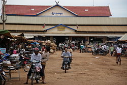
 Market in Banlung | |
| Country | |
| Province | Ratanakiri Province |
| District | Banlung District |
| Population (2006) | |
| • Total | 17,000 |
| Time zone | UTC+7 (Cambodia) |
Template:Contains Khmer text Banlung (Khmer: បានលុង) is the capital of Ratanakiri Province in northeastern Cambodia. Banlung is 636 km from the Cambodian capital of Phnom Penh. Ratanakiri province borders Vietnam and Laos.[1] Banlung is also the capital of the Banlung District. The city has a population of around 17,000 and the surrounding district has a population of 23 888. The town became the capital of Ratanakiri province in 1979, following the fall of the Khmer Rouge. The capital was moved from Voen Sai to Banlung in order to facilitate trade with Vietnam (previous to Voen Sai the capital was Lumphat).[2] Prior to 1979 the town was known as Labansiek.[1] It is a relatively lively commercial center; ethnic minorities from surrounding villages often come to the city market to sell their goods.[1]
Banlung district contains 16 villages located in three communes.
Communes
| Commune (khum) | Villages (phum)[3][4] | Population (1998)[3] |
|---|---|---|
| Kachanh | Phum Muoy, Phum Pir, Phum Bei, Phum Buon | 3,888 |
| Labansiek | Phum Muoy, Phum Pir, Phum Bei, Phum Buon, Phum Pram, Phum Prammuoy, Phum Prampir (Village 1, 2, 3, 4, 5, 6, 7) | 11,256 |
| Yeak Laom | Lon, Phnum, Sil, La Pou, Chri | 1,855 |

References
- ^ a b c Ray, Nick. Cambodia. Lonely Planet (2002), p315. ISBN 1-74059-111-9.
- ^ The Rough Guide to Cambodia By Beverley Palmer, p. 238 http://www.roughguides.com/travel/asia/cambodia/the-northeast/rattanakiri-province/banlung.aspx)
- ^ a b "Final Population Totals, Rotanak Kiri Province, 1998" Archived 2008-10-29 at the Wayback Machine. Cambodia National Institute of Statistics. Accessed June 6, 2008.
- ^ "Ratanak Kiri Province" Archived 2008-06-02 at the Wayback Machine. Cambodia National Institute of Statistics. Accessed June 6, 2008.
External links
Big Stories, Small Towns http://bigstories.com.au/#/town/banlung an online documentary about the town of Banlung

