Franklin Street station (IRT Broadway–Seventh Avenue Line): Difference between revisions
Epicgenius (talk | contribs) →Station layout: ref |
Rescuing 1 sources and tagging 0 as dead. #IABot (v1.2.7.1) |
||
| Line 69: | Line 69: | ||
* {{NYCS ref|http://www.nycsubway.org/perl/stations?6:1383|IRT West Side Line|Franklin Street}} |
* {{NYCS ref|http://www.nycsubway.org/perl/stations?6:1383|IRT West Side Line|Franklin Street}} |
||
* nycsubway.org – [http://www.nycsubway.org/perl/artwork_show?111 Alleyways, Tribeca Artwork by Susan Leopold (2005)] |
* nycsubway.org – [http://www.nycsubway.org/perl/artwork_show?111 Alleyways, Tribeca Artwork by Susan Leopold (2005)] |
||
* Station Reporter – [http://www.stationreporter.net/1train.htm 1 Train] |
* Station Reporter – [https://web.archive.org/web/20141010102251/http://www.stationreporter.net/1train.htm 1 Train] |
||
* [https://maps.google.com/maps?ie=UTF8&ll=40.719103,-74.006921&spn=0.003822,0.013433&z=17&layer=c&cbll=40.718977,-74.006836&panoid=-VIj1KO4e50kGw-625-S7A&cbp=12,78.36,,0,6.51 Franklin Street entrance from Google Maps Street View] |
* [https://maps.google.com/maps?ie=UTF8&ll=40.719103,-74.006921&spn=0.003822,0.013433&z=17&layer=c&cbll=40.718977,-74.006836&panoid=-VIj1KO4e50kGw-625-S7A&cbp=12,78.36,,0,6.51 Franklin Street entrance from Google Maps Street View] |
||
* [https://maps.google.com/maps?ll=40.71912,-74.007189&spn=0.002765,0.009645&layer=c&cbll=40.719155,-74.006939&panoid=6V8zgzqHJXLK9Y3grCBakQ&cbp=12,309.08,,1,2.73&t=m&z=17 Varick Street entrance from Google Maps Street View] |
* [https://maps.google.com/maps?ll=40.71912,-74.007189&spn=0.002765,0.009645&layer=c&cbll=40.719155,-74.006939&panoid=6V8zgzqHJXLK9Y3grCBakQ&cbp=12,309.08,,1,2.73&t=m&z=17 Varick Street entrance from Google Maps Street View] |
||
Revision as of 18:27, 4 January 2017
Franklin Street | |||||||||
|---|---|---|---|---|---|---|---|---|---|
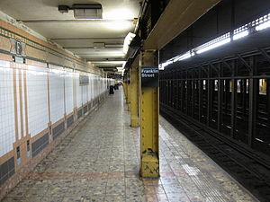
 Uptown platform | |||||||||
| Station statistics | |||||||||
| Address | Franklin Street & Varick Street New York, NY 10013 | ||||||||
| Borough | Manhattan | ||||||||
| Locale | Tribeca | ||||||||
| Division | A (IRT)[1] | ||||||||
| Line | IRT Broadway–Seventh Avenue Line | ||||||||
| Services | 1 2 | ||||||||
| Transit | |||||||||
| Structure | Underground | ||||||||
| Platforms | 2 side platforms | ||||||||
| Tracks | 4 | ||||||||
| Other information | |||||||||
| Opened | July 1, 1918 | ||||||||
| Opposite- direction transfer | No | ||||||||
| Traffic | |||||||||
| 2023 | 1,329,726[2] | ||||||||
| Rank | 234 out of 423[2] | ||||||||
| Station succession | |||||||||
| Next north | Template:NYCS next | ||||||||
| Next south | Template:NYCS next | ||||||||
| |||||||||

Franklin Street is a local station on the IRT Broadway–Seventh Avenue Line of the New York City Subway, located at the intersection of Franklin Street, Varick Street, and West Broadway.[4] It is served by the 1 train at all times, and by the 2 train during late nights.
Station layout
Track layout | |||||||||||||||||||||||||||||||||||||||||||||||||||||||||||||||
|---|---|---|---|---|---|---|---|---|---|---|---|---|---|---|---|---|---|---|---|---|---|---|---|---|---|---|---|---|---|---|---|---|---|---|---|---|---|---|---|---|---|---|---|---|---|---|---|---|---|---|---|---|---|---|---|---|---|---|---|---|---|---|---|
| |||||||||||||||||||||||||||||||||||||||||||||||||||||||||||||||
| Ground | Street level | Exit/entrance |
| Platform level | Side platform | |
| Northbound local | ← ← | |
| Northbound express | ← | |
| Southbound express | | |
| Southbound local | | |
| Side platform | ||
The station has two side platforms and four tracks with no crossover or crossunder.[5]
There are "store window"-style art displays on the southbound platform and a faux-newsstand on the northbound side.[5] Although the station's original wall tiling was replaced during renovations, its mosaic bands were kept; there are "Franklin Street" large mosaics, small "F" mosaics and directional mosaics "To Franklin St." and "To North Moore St."[5] The floor tiles are rose-colored.[5]
Exits
The full-time entrance is on the uptown side, on a traffic island where Varick Street and West Broadway meet.[6] There is a kiosk reminiscent of the original IRT kiosks at 72nd Street and Bowling Green, but it was added during the station's renovation during the mid-1990s.[5] There are two downtown street stair entrances on either western corner of Varick and Franklin Streets, but the booth is not staffed at all times. There are part-time high-exit turnstiles one block north, at both northern corners of Varick and North Moore Streets, on both the uptown and downtown sides.[6]
References
- ^ "Glossary". Second Avenue Subway Supplemental Draft Environmental Impact Statement (SDEIS) (PDF). Vol. 1. Metropolitan Transportation Authority. March 4, 2003. pp. 1–2. Archived from the original (PDF) on February 26, 2021. Retrieved January 1, 2021.
- ^ a b "Annual Subway Ridership (2018–2023)". Metropolitan Transportation Authority. 2023. Retrieved April 20, 2024.
- ^ "Facts and Figures: Annual Subway Ridership". New York City Metropolitan Transportation Authority. Retrieved 2016-04-19.
- ^ 1 Broadway - Seventh Avenue Line Local line map MTA Retrieved 2008-05-20
- ^ a b c d e IRT West Side Line: Franklin Street NYCSubway Retrieved 2008-05-20
- ^ a b "MTA Neighborhood Maps: SoHo / Tribeca" (PDF). Metropolitan Transportation Authority. 2015. Retrieved August 6, 2015.
External links

- nycsubway.org – IRT West Side Line: Franklin Street
- nycsubway.org – Alleyways, Tribeca Artwork by Susan Leopold (2005)
- Station Reporter – 1 Train
- Franklin Street entrance from Google Maps Street View
- Varick Street entrance from Google Maps Street View
- Moore Street exit only stairs from Google Maps Street View
- Platforms from Google Maps Street View

