Hungerford, Hampshire: Difference between revisions
Appearance
Content deleted Content added
JJMC89 bot (talk | contribs) Migrate {{Infobox UK place}} coordinates parameters to {{Coord}}, see Wikipedia:Coordinates in infoboxes |
Rescuing 2 sources and tagging 0 as dead. #IABot (v1.3beta4) |
||
| Line 19: | Line 19: | ||
'''Hungerford''' is a [[Hamlet (place)#United Kingdom|hamlet]] in the [[New Forest]] National Park of [[Hampshire]], England. Its nearest town is [[Fordingbridge]], which lies approximately 2 miles (3.4 km) north-west of the village. |
'''Hungerford''' is a [[Hamlet (place)#United Kingdom|hamlet]] in the [[New Forest]] National Park of [[Hampshire]], England. Its nearest town is [[Fordingbridge]], which lies approximately 2 miles (3.4 km) north-west of the village. |
||
Hungerford is a hamlet in the [[civil parish]] of [[Hyde, Hampshire|Hyde]], and it is located just to the south of the village of Hyde. With just 11 dwellings, Hungerford is the smallest hamlet in the parish.<ref name="hydepcdesign7">[http://www.hyde-pc.gov.uk/index.cfm?articleid=8616 Hyde Parish Village Design Statement], page 7</ref> Hungerford is notable for its triangular village green bordered by two white thatched cottages, a cob farmhouse, and a traditional cottage.<ref name="hydepcdesign8">[http://www.hyde-pc.gov.uk/index.cfm?articleid=8616 Hyde Parish Village Design Statement], page 8</ref> A country house built in 1927 is situated on the southern edge of the hamlet.<ref name="hydepcdesign8"/> |
Hungerford is a hamlet in the [[civil parish]] of [[Hyde, Hampshire|Hyde]], and it is located just to the south of the village of Hyde. With just 11 dwellings, Hungerford is the smallest hamlet in the parish.<ref name="hydepcdesign7">[http://www.hyde-pc.gov.uk/index.cfm?articleid=8616 Hyde Parish Village Design Statement] {{webarchive|url=https://web.archive.org/web/20120731115850/http://www.hyde-pc.gov.uk/index.cfm?articleid=8616 |date=2012-07-31 }}, page 7</ref> Hungerford is notable for its triangular village green bordered by two white thatched cottages, a cob farmhouse, and a traditional cottage.<ref name="hydepcdesign8">[http://www.hyde-pc.gov.uk/index.cfm?articleid=8616 Hyde Parish Village Design Statement] {{webarchive|url=https://web.archive.org/web/20120731115850/http://www.hyde-pc.gov.uk/index.cfm?articleid=8616 |date=2012-07-31 }}, page 8</ref> A country house built in 1927 is situated on the southern edge of the hamlet.<ref name="hydepcdesign8"/> |
||
==References== |
==References== |
||
Revision as of 17:59, 6 April 2017
| Hungerford | |
|---|---|
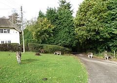
 Donkeys on the green at Hungerford | |
Location within Hampshire | |
| OS grid reference | SU167121 |
| Civil parish | |
| District | |
| Shire county | |
| Region | |
| Country | England |
| Sovereign state | United Kingdom |
| Post town | FORDINGBRIDGE |
| Postcode district | SP62 |
| Dialling code | 01425 |
| Police | Hampshire and Isle of Wight |
| Fire | Hampshire and Isle of Wight |
| Ambulance | South Central |
| UK Parliament | |
Hungerford is a hamlet in the New Forest National Park of Hampshire, England. Its nearest town is Fordingbridge, which lies approximately 2 miles (3.4 km) north-west of the village.
Hungerford is a hamlet in the civil parish of Hyde, and it is located just to the south of the village of Hyde. With just 11 dwellings, Hungerford is the smallest hamlet in the parish.[1] Hungerford is notable for its triangular village green bordered by two white thatched cottages, a cob farmhouse, and a traditional cottage.[2] A country house built in 1927 is situated on the southern edge of the hamlet.[2]
References
- ^ Hyde Parish Village Design Statement Archived 2012-07-31 at the Wayback Machine, page 7
- ^ a b Hyde Parish Village Design Statement Archived 2012-07-31 at the Wayback Machine, page 8


