Independência, Ceará: Difference between revisions
Appearance
Content deleted Content added
JJMC89 bot (talk | contribs) Migrate {{Infobox settlement}} coordinates parameters to {{Coord}}, see Wikipedia:Coordinates in infoboxes |
Rescuing 1 sources and tagging 1 as dead. #IABot (v1.3beta4) |
||
| Line 27: | Line 27: | ||
|area_note = |
|area_note = |
||
|area_total_km2 = 3,218.641 |
|area_total_km2 = 3,218.641 |
||
|population_note = <ref name="IBGE_Pop_2012">{{cite web |
|population_note = <ref name="IBGE_Pop_2012">{{cite web|url=ftp://ftp.ibge.gov.br/Estimativas_Projecoes_Populacao/Estimativas_2012/estimativa_2012_municipios.pdf |title=2012 Populational Estimate |work=Censo Populacional 2012 |publisher=Instituto Brasileiro de Geografia e Estatística (IBGE) |date=July 2012 |accessdate=September 9, 2012 }}{{dead link|date=April 2017 |bot=InternetArchiveBot |fix-attempted=yes }}</ref> |
||
|population_as_of = 2012 |
|population_as_of = 2012 |
||
|population_total = 25,620 |
|population_total = 25,620 |
||
| Line 38: | Line 38: | ||
|elevation_ft = 343 |
|elevation_ft = 343 |
||
|blank_name = '''[[Human Development Index|HDI]]''' (2000) |
|blank_name = '''[[Human Development Index|HDI]]''' (2000) |
||
|blank_info = 0.657 – <span style="color:#fc0">medium</span><ref>[http://www.pnud.org.br/atlas/ranking/IDH-M%2091%2000%20Ranking%20decrescente%20(pelos%20dados%20de%202000).htm] [[UNDP]]</ref> |
|blank_info = 0.657 – <span style="color:#fc0">medium</span><ref>[http://www.pnud.org.br/atlas/ranking/IDH-M%2091%2000%20Ranking%20decrescente%20(pelos%20dados%20de%202000).htm] {{webarchive|url=https://web.archive.org/web/20091003103229/http://www.pnud.org.br/atlas/ranking/IDH-M%2091%2000%20Ranking%20decrescente%20%28pelos%20dados%20de%202000%29.htm |date=2009-10-03 }} [[UNDP]]</ref> |
||
|website = [http://www.independencia.ce.gov.br/ www.independencia.ce.gov.br/] |
|website = [http://www.independencia.ce.gov.br/ www.independencia.ce.gov.br/] |
||
|footnotes = |
|footnotes = |
||
Revision as of 06:02, 10 April 2017
Independência | |
|---|---|
Municipality | |
| The Municipality of Independência | |
| Nickname: "Porronca" | |
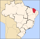
 Location of Independência in the State of Ceará | |
| Coordinates: 05°23′45″S 40°18′32″W / 5.39583°S 40.30889°W | |
| Country | |
| Region | Northeast |
| State | |
| Founded | July 24, 1857 |
| Government | |
| • Mayor | José Valdi Coutinho (PMDB) |
| Area | |
| • Total | 3,218.641 km2 (1,242.724 sq mi) |
| Elevation | 105 m (343 ft) |
| Population (2012) | |
| • Total | 25,620 |
| • Density | 8.0/km2 (21/sq mi) |
| [1] | |
| Time zone | UTC-3 (UTC-3) |
| HDI (2000) | 0.657 – medium[2] |
| Website | www.independencia.ce.gov.br/ |
Independência is a municipality of the Northeastern state of Ceará in Brazil. It is the fourth largest by area in that state.
References
- ^ "2012 Populational Estimate" (PDF). Censo Populacional 2012. Instituto Brasileiro de Geografia e Estatística (IBGE). July 2012. Retrieved September 9, 2012.[permanent dead link]
- ^ [1] Archived 2009-10-03 at the Wayback Machine UNDP

