
Bayside station (LIRR): Difference between revisions
added link |
Rescuing 1 sources and tagging 0 as dead. #IABot (v1.4.2) |
||
| Line 31: | Line 31: | ||
| mpassengers= |
| mpassengers= |
||
}} |
}} |
||
'''Bayside''' (formerly '''Bay Side''')<ref>[http://digitalarchives.queenslibrary.org/vital/access/services/Download/aql:336/SOURCE1?view=true The Long Island Rail Road A Comprehensive History by Vincent F. Seyfried Part Two The Flushing, North Shore & Central Railroad]</ref> is a [[train station|station]] in the [[Bayside, Queens|Bayside]] section of [[Queens]] in [[New York City]] on the [[Port Washington Branch]] of the [[Long Island Rail Road]]. The station is located at 213th Street and 41st Avenue, off Bell Boulevard and just north of [[Northern Boulevard]], and is 12.6 miles (20.3 km) from [[Pennsylvania Station (New York City)|Penn Station]] in [[Midtown, Manhattan|Midtown Manhattan]]. The station is part of [[Long Island Rail Road#Fare structure|CityTicket]]. |
'''Bayside''' (formerly '''Bay Side''')<ref>[http://digitalarchives.queenslibrary.org/vital/access/services/Download/aql:336/SOURCE1?view=true The Long Island Rail Road A Comprehensive History by Vincent F. Seyfried Part Two The Flushing, North Shore & Central Railroad] {{webarchive|url=https://web.archive.org/web/20150419021129/http://digitalarchives.queenslibrary.org/vital/access/services/Download/aql%3A336/SOURCE1?view=true |date=April 19, 2015 }}</ref> is a [[train station|station]] in the [[Bayside, Queens|Bayside]] section of [[Queens]] in [[New York City]] on the [[Port Washington Branch]] of the [[Long Island Rail Road]]. The station is located at 213th Street and 41st Avenue, off Bell Boulevard and just north of [[Northern Boulevard]], and is 12.6 miles (20.3 km) from [[Pennsylvania Station (New York City)|Penn Station]] in [[Midtown, Manhattan|Midtown Manhattan]]. The station is part of [[Long Island Rail Road#Fare structure|CityTicket]]. |
||
==History== |
==History== |
||
Revision as of 12:36, 16 July 2017
Bayside | |||||||||||
|---|---|---|---|---|---|---|---|---|---|---|---|
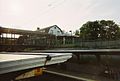
 View of Bayside station house and pedestrian bridge from above the eastbound ramp. | |||||||||||
| General information | |||||||||||
| Location | 213th Street & 41st Avenue Bayside, New York | ||||||||||
| Coordinates | 40°45′47″N 73°46′18″W / 40.763105°N 73.771804°W | ||||||||||
| Owned by | Long Island Rail Road | ||||||||||
| Line(s) | |||||||||||
| Platforms | 2 side platforms | ||||||||||
| Tracks | 2 | ||||||||||
| Connections | |||||||||||
| Construction | |||||||||||
| Parking | Yes (metered, NYC permit, & private) | ||||||||||
| Bicycle facilities | Yes | ||||||||||
| Accessible | Yes | ||||||||||
| Other information | |||||||||||
| Fare zone | 3 | ||||||||||
| History | |||||||||||
| Opened | October 27, 1866 (NY&F)[1] | ||||||||||
| Rebuilt | 1923 (station house) 1928–1930 (grade elimination) | ||||||||||
| Electrified | October 21, 1913 750 V (DC) third rail | ||||||||||
| Previous names | Bay Side (1866–1872) | ||||||||||
| Passengers | |||||||||||
| 2006 | 8,649[2] | ||||||||||
| Services | |||||||||||
| |||||||||||
Bayside (formerly Bay Side)[3] is a station in the Bayside section of Queens in New York City on the Port Washington Branch of the Long Island Rail Road. The station is located at 213th Street and 41st Avenue, off Bell Boulevard and just north of Northern Boulevard, and is 12.6 miles (20.3 km) from Penn Station in Midtown Manhattan. The station is part of CityTicket.
History
Bayside station was originally built on October 27, 1866, by the North Shore Railroad of Long Island, a subsidiary of the New York and Flushing Railroad. The station, along with the rest of the line was acquired by the Flushing and North Side Rail Road in 1869. The F&NS was consolidated into the Flushing, North Shore and Central Railroad in 1874 through a merger with the Central Railroad of Long Island, only to be leased in 1876 by the LIRR. The current station building dates to October 11, 1923. The tracks were depressed beneath Bell Boulevard from 1928 through 1930. A railway express elevator building was then opened on the eastbound side until the Port Washington Branch stopped carrying freight. The 1928 express/baggage station remains today, being converted into a local community center. The wooden pedestrian bridge that carried commuters across the tracks to both platforms was replaced in 1998 by a decorative steel bridge.
The station, along with the Port Washington line in general, is heavily used. During the 2005 New York City transit strike, the station had the distinction of being one of the few where trains stopped, bypassing lesser stations on the Port Washington branch such as Auburndale and Murray Hill.[4][5]
Station layout
The station has two slightly offset side platforms, each 10 cars long.
| G | Ground level | Exit/entrance, crossover, buses |
| P Platform level | ||
| Platform A, doors will open on the right | ||
| Track 1 | ← Port Washington Branch toward Penn Station (Auburndale) | |
| Track 2 | Port Washington Branch toward Great Neck or Port Washington (Douglaston) → | |
| Platform B, doors will open on the right | ||
Gallery
-
 Station house on July 3, 2007
 -
 Station house from 41st Avenue
 -
 The former freight house, and Bell Boulevard Bridge.


References
- ^ Vincent F. Seyfried, The Long Island Rail Road: A Comprehensive History, Part Two: The Flushing, North Shore & Central Railroad, © 1963.
- ^ Average weekday, 2006 LIRR Origin and Destination Study
- ^ The Long Island Rail Road A Comprehensive History by Vincent F. Seyfried Part Two The Flushing, North Shore & Central Railroad Archived April 19, 2015, at the Wayback Machine
- ^ MTA Strike Contingency Plan: Long Island Rail Road Information
- ^ "NYC Transit Strike Day 2 in Queens - Tips and News," by John Roleke, (About.com; December 20, 2005)