
Mam Tor
| Mam Tor |
|---|
Mam Tor is a 517 m (1696 ft) hill near Castleton in the High Peak of Derbyshire, England. Its name literally translates[vague] as Heights of the Mother[citation needed] and it is also known as the Shivering Mountain on account of the instability of its lower shale layers.[1] Indeed, in 1979 the continual battle to maintain the A625 road (Sheffield to Chapel en le Frith) on the crumbling southern side of the hill was lost when the road officially closed as a through-route.
The summit of Mam Tor is encircled by a late Bronze Age and early Iron Age hill fort. Radiocarbon analysis suggests occupation from around 1200 BC. The earliest remaining features are two Bronze Age burial mounds, one just below the summit and the other on the summit itself. At a later stage over a hundred small platforms were levelled into the hill near the summit, allowing inhabited timber huts to be constructed.
At the base of the Tor and nearby are three show caves: Speedwell Cavern, Blue John Cavern and Treak Cliff Cavern where lead, Blue John, fluor spar and other minerals were once mined. The Tor sits near the top of Winnats Pass (a steep and narrow limestone gorge), forms the eastern end of Rushup Edge, and dominates the western end of the "Great Ridge", one of the most famous, beautiful, and easy-to-reach ridgewalks in the Peak District.
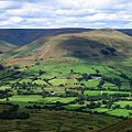
The Ridge separates the two arms of the Hope Valley: the valley of the River Noe (Edale) to the north, and the Peakshole Water (Castleton) to the south. Starting at the western end, the walker leaves the summit of Mam Tor, passes the remains of the fort's earthworks, dips into the saddle of Hollins Cross, climbs to Back Tor, then dips and climbs again to the conical peak of Lose Hill at the eastern end of the Ridge. In the other direction, walkers who have climbed Lose Hill from Hope railway station see Mam Tor as a dramatic target for an easy one-hour walk with beautiful views on either side. A common target for walkers from Edale or Castleton is the dip of Hollins Cross, the meeting place of many paths visible from the valley bottoms on both sides. Other walkers take the longer route past the show caves (i.e. via Winnats Pass or the old A-road) or Barber Booth. Back Tor has a steep and distinctive shale face, which is occasionally climbable [2] when hard-frozen.
In perfect weather conditions, Manchester City Centre, Stockport, and Winter Hill can be seen from here.
Mam Tor Landslide

One of the distinguishing features of Mam Tor Peak is the active debris flow resulting from a rotational landslide that occurred roughly 4,000 years ago. The initial failure exposed bedrock displaying a sequence of shales and sandstones near to the summit. Evidence for the continued movement of the slide mass is demonstrated graphically by the complete destruction of a road that once crossed the width of the failure. The road was originally built at the beginning of the 1800s and was subsequently relaid until local authorities closed the road in 1979. Layers of tarmac and gravel are up to 2 metres thick in places, demonstrating the numerous efforts to keep the road open.
Current mean annual movement according to a study made in 2000 [3] is:
up to 0.25 m; this increases greatly when winter rainfalls exceed thresholds of both 210 mm/month and 750 mm in the preceding six months
The debris flow poses no threat to any inhabited buildings near the peak; however, small farm buildings lying in the flow's path may become inundated over the next century assuming a flow rate similar to that of the present. The 2000 study suggests that deep drainage may be the most effective means of stabilising the flow, though this may not completely stop movement.
References
- ^ Natural Curiosities of Derbyshire, in: The Every-day Book and Table Book; or, Everlasting Calendar of Popular Amusements, Sports, Pastimes, Ceremonies, Manners, Customs, and Events, Each of the Three Hundred and Sixty-Five Days, in Past and Present Times; Forming a Complete History of the Year, Months, and Seasons, and a Perpetual Key to the Almanac, Including Accounts of the Weather, Rules for Health and Conduct, Remarkable and Important Anecdotes, Facts, and Notices, in Chronology, Antiquities, Topography, Biography, Natural History, Art, Science, and General Literature; Derived from the Most Authentic Sources, and Valuable Original Communication, with Poetical Elucidations, for Daily Use and Diversion. Vol III., ed. William Hone, (London: 1838) p 11-16. Retrieved on 2008-06-24.
- ^ Nunn, Paul (1977), Rock Climbing in the Peak District, Constable
- ^ Waltham & Dixon (2000), Movement of the Mam Tor landslide, Derbyshire, UK, The Quarterly Journal of Engineering Geology and Hydrogeology, Volume 33, Number 2, May 2000, pp. 105-123(19)
-
View of the village of Castleton from Mam Tor
-
View of the Hope Valley
-
 Paragliding from Mam Tor
 -
 View from Mam Tor looking north towards the Vale of Edale
 -
 A section of the abandoned road
 -
 Path leading to Mam Tor from Lose Hill


See also
Further reading
- Coombs, D. G.; Thompson, F.H. (1979), "Excavation of the hillfort of Mam Tor, Derbyshire", Derbyshire Archaeological Journal, 99: 7–51
