
Lambeth North tube station
| Lambeth North | |
|---|---|
 | |
| Location | Lambeth |
| Local authority | Lambeth |
| Managed by | London Underground |
| Number of platforms | 2 |
| Fare zone | 1 |
| London Underground annual entry and exit | |
| 2006 | |
| 2007 | |
| 2008 | |
| 2009 | |
| Key dates | |
| 1906 | Opened |
| Other information | |
Lambeth North tube station is a London Underground station in the neighbourhood of Lambeth, at the junction of Westminster Bridge Road and Baylis Road. It is on the Bakerloo line, between Elephant & Castle and Waterloo, and is in Travelcard Zone 1. It is located at 110 Westminster Bridge Road, and is the nearest tube station to the Imperial War Museum.
History
Designed by Leslie Green, the station was opened by Baker Street & Waterloo Railway on 10 March 1906, with the name Kennington Road. It served as the temporary southern terminus of the line until 5 August 1906, when Elephant & Castle station was opened. The station's name was changed to Westminster Bridge Road in July 1906 and it was again renamed, to Lambeth North, in April 1917.
At 03:56 on 16 January 1941, a German "Satan" 1800 kg general-purpose bomb hit a hostel at nearby 92 Westminster Bridge Road. The shock-wave severely damaged the southbound platform tunnel, and injuring 28 people sheltering there, one of whom died in hospital 15 days later. Thirty-seven rings of the damaged tunnel had to be completely replaced, 15 partially replaced, and 86 feet of platform rebuilt. Traffic through the station resumed in 95 days.
The station was closed with the section of the line south of Piccadilly Circus for tunnel strengthening works between 9 November 1996 and 14 July 1997.
Layout
There are two tracks in separate tunnels The station has two lifts and a spiral staircase connecting the road level to platform level (about 70 feet below).
Gallery
-
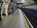 Northbound platform looking south
 -
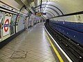 Southbound platform looking north
 -
 Platform roundel
 -
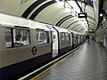 A southbound train waits at Lambeth North


References
- ^ a b c "Multi-year station entry-and-exit figures (2007–2017)". London Underground station passenger usage data. Transport for London. January 2018. Archived from the original (XLSX) on 31 July 2018. Retrieved 22 July 2018. Cite error: The named reference "infobox_stats_ref_tube_2007" was defined multiple times with different content (see the help page).
Transport links
London bus route 12, 53, 59, 148, 159, 453 and night route N109.
External links
51°29′56″N 0°06′42″W / 51.499°N 0.1118°W
| Stations |
| ||||||||||
|---|---|---|---|---|---|---|---|---|---|---|---|
| Non-revenue stations | |||||||||||
| Rolling stock | |||||||||||
| Depots | |||||||||||
| Proposed extension | |||||||||||
| History |
| ||||||||||