
Punta Arenas
Punta Arenas
Magallanes | |
|---|---|
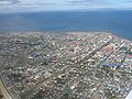
 View of the city of Punta Arenas. In the background the Strait of Magellan and the north coast of Tierra del Fuego ( Isla Grande De Tierra del Fuego ) | |
 Coat of arms | |
 | |
| Country | Chile |
| Region | XII - Magallanes y Antártica Chilena |
| Province | Magallanes |
| Founded as | Punta Arenas |
| Foundation | 18 December 1848 |
| Government | |
| • Mayor | Vladimiro Mimica (2008 - Present) |
| Area | |
| • Total | 17,526.3 km2 (6,766.9 sq mi) |
| Population (2002) | |
| • Total | 154,000 |
| • Density | 6.8/km2 (18/sq mi) |
| Time zone | UTC-4 |
| • Summer (DST) | UTC-3 |
| Area code | 61 |
| Website | http://www.puntaarenas.cl |


Punta Arenas (English: "Sandy Point") is the most prominent settlement on the Strait of Magellan.
Punta Arenas is the capital of the Magallanes y la Antártica Chilena Region, Chile. The city itself was officially renamed Magallanes in 1927, but in 1938 it was changed back to Punta Arenas. It is regarded as the world's southernmost city.
Etymology
The 17th century explorer John Byron is sometimes given credit for the naming. But it was not until much later than any sort of city was settled by the Chilean government (1843). The name Punta Arenas grew out of the Spanish term Punta Arenosa, which was a literal translation of the English name 'Sandy Point'. The city has also been known as "Magallanes" though today that term is normally used to describe the administrative region which includes the city. Punta Arenas has also been called "the city of the red roofs" for the red-painted metal roofs that characterized the city for many years, although since about 1970 the availability of other colors in protective finishes for the characteristic metal roofing has resulted in greater variety.
Geography
Located on the Brunswick Peninsula. Punta Arenas is the third largest city in the entire Patagonian Region, after the more northerly Argentine cities of Neuquén and Comodoro Rivadavia. In 2002, it had a population of 120,000.[1] It is roughly 1418.4 km from the coast of Antarctica.
The Magallanes region is considered part of Chilean Patagonia. Magallanes is Spanish for Magellan, the Portuguese explorer who, while circumnavigating the earth for Spain, passed close to the present site of Punta Arenas in 1520. Early English navigational documents referred to its location as "Sandy Point".
The city proper is located on the northeastern shore of Brunswick Peninsula. Besides the eastern shore, with the settlements of Guairabo, Rio Amarillo and Punta San Juan, the peninsula is largely uninhabited. The municipality (commune) of Punta Arenas includes all of Brunswick Peninsula, as well as all islands west of the Isla Grande de Tierra del Fuego and north of Cockburn Channel and Magdalena Channel. The largest of those are:
- Santa Inés Island
- Desolación Island
- Dawson Island
- Aracena Island
- Clarence Island
- Carlos Island
- Wickham Island
Except Dawson Island, with a population of about 301 in 2002, the islands are largely uninhabited. Clarence Island had a population of just five.
History
Two early Spanish settlements attempted along this coast (on the Straits of Magellan), including the first (1584), called Nombre de Jesús, failed in large part due to the harsh weather and difficulty in obtaining food and water, and the enormous distances from other Spanish ports. A second colony, Rey don Felipe, was attempted at another location some 80 kilometres south of Punta Arenas. This became known later as Puerto Hambre, sometimes translated as Port Starvation or Famine Port. These Spanish settlements had been established with the intent to prevent piracy by English pirates, by controlling the Straits of Magellan. Ironically it was an English pirate captain, Thomas Cavendish, who rescued the last surviving member of Puerto Hambre in 1587.
As said above, in the year 1843 the Chilean government sent an expedition with the appointed task of establishing a permanent settlement on the shores of the Strait of Magellan. For this it built and commissioned a small sail ship called Goleta Ancud, which under the command of the British sailor John Williams, father of Juan Williams Rebolledo, transported a crew of 21 people (captain, eighteen crew, two women), plus cargo, to accomplish the mandate of the Chilean government. The founding act of the settlement took place on 21 September 1843.
Although the site was perfectly suited for a military garrison with the mission of coastal defence, since it is located on top of a small rocky peninsula, it was ill prepared to become a proper civilian settlement. With this in mind the Military Governor, José de los Santos Mardones, decided in 1848 to move the settlement to its current location, on the sides of the Las Minas river, renaming it Punta Arenas.
In the mid-19th century, Chile used Punta Arenas as a penal colony and a disciplinary posting for military personnel with "problematic" behaviour, as well as a place for immigrant colonisation. In December 1851, a prisoners' mutiny led by Lieutenant Cambiaso, resulted in the murder of Governor Muñoz Gamero and the priest, and the destruction of the church and the hospital.[2] The mutiny was put down by Commander Stewart of HMS Virago assisted by two Chilean ships: Indefatigable and Meteoro.[3][4] In 1877 a mutiny, known as "El motín de los artilleros" (Mutiny of the Artillerymen) led to the destruction of a large part of the town and the murder of many civilians not directly associated with the prison. In time the city was restored and with the growth of the sheep industry and the discovery of gold, as well as increasing trade via sailing ships, began to prosper. Between about 1890 and 1940, the Magallanes region became one of the world's most important sheep-raising regions, with one company (Sociedad Explotadora de Tierra del Fuego) controlling over 10,000 square kilometres in southern Chile and Argentina. The headquarters of this company and the residences of the owners were in Punta Arenas. Visitors today can get a glimpse of the economic stature of the city, or at least of its leading citizens, by touring the Sarah Braun museum (sometimes called Braun-Menéndez mansion) in the centre of Punta Arenas. Other popular attractions include the two nearby rookeries for Magellanic penguins, and the rebuilt site of the failed Fuerte Bulnes settlement.
The Punta Arenas harbour, although exposed to storms, was considered one of the most important in Chile before the construction of the Panama Canal, because it was used as a coaling station by the steamships transiting between the Atlantic and Pacific Oceans. Today it is mostly used by tourism cruises and scientific expeditions. The city is often a jumping-off point for Antarctic expeditions, although Ushuaia (Argentina) and Christchurch (New Zealand) are also common starting points.[5]

Economy
By 2006 the economy of Punta Arenas and the region had diversified considerably, and the city is vibrant and modern. Chile's principal oil reserves, though small, are located here, along with some low-grade coal. A modern methanol plant is located a short distance from the city. Agricultural production, including sheep and cattle, continues to play a significant role, while tourism has contributed to its popularity and steady growth. Fisheries and silviculture are also significant here. A regular ferry service connects Punta Arenas with the main island of Tierra del Fuego and a less frequent ferry runs to the Chilean town of Puerto Williams. A modern airport serves international connections and is often a stopping point for aircraft going to or coming from Antarctica. Paved highways connect Punta Arenas with Argentina.
Since the Falklands War, when transport ties were severed between the Falkland Islands and continental Argentina, Punta Arenas has become a major outside link to the archipelago.
Demography
Punta Arenas has a population of over 154,000 inhabitants (2008).[6] The city has its roots among the population origin of the European colonists (Croatian and Spanish) that populated the area at mid-nineteenth century. One can also find colonies of descendants of people from other countries (i.e. German, English, Italian, Swiss and others).
Croatian immigration in Punta Arenas was a crucial development in the region of Magallanes and the city in particular. Currently, you can see this influence in the names of shops and many buildings. According to some references to 50% of the population of Punta Arenas would be descendants of Croats.[7]
The most important are the port, the oil industry and trade and services, followed by livestock, mostly sheep, fishing and forestry. Depart from Punta Arenas that address some cruises to Antarctica, and its port reaching the majority of European and transatlantic cruise tours as well as flights from the airport to leave the Falkland Islands, Antarctica and the rest of the country with daily flights to the capital Santiago and other cities such as Puerto Montt and Concepción.
Climate
Punta Arenas has a semi-arid, ocean-moderated climate (Köppen climate classification BSk). The seasonal temperature in Punta Arenas is greatly moderated by its proximity to the ocean, with specifying average lows in July near −1 °C (30 °F) and highs in January of 14 °C (57 °F). This is not to say that it is known for stable constant temperatures, only small variability with season. Rainfall is most plentiful between April and May and snow season goes all through Chilean winter (June till September), although the average temperature does not descend below the 1°C.[8] Among Chileans the city is also known for its strong winds (up to 130 km/hour). Winds tend to be strongest during the summer when city officials put up ropes in the downtown area to assist with unique wind currents created by the buildings.
Since 1986, Punta Arenas has been the first significantly populated city in the world to be directly affected by the hole in the ozone layer, exposing its residents to potentially damaging levels of ultraviolet radiation.[9][6]
 |
 |
Access
Punta Arenas can be accessed by sea, by land or air.
Presidente Carlos Ibáñez del Campo International Airport (IATA: PUQ, ICAO: SCCI), located 20 km north of the city, is the main gateway to the region and serves Punta Arenas. Transport, rental car, duty free shops and custom office services are available in the building. Airlines serving the airport include LAN Chile, Sky Airlines and Aerolíneas del Sur as well as charter flights.
By road, passing through Argentine territory is mandatory as there are no direct routes within Chilean territory.[8]
By sea, several cruises and ferries can take you to the city, although the costs are much higher because they include stops at tourist sites along the route.
Sister cities
Punta Arenas has the following sister city relationships, according to Bellingham Sister Cities Association, and Sister Cities International:
 Bellingham, Washington, United States
 Split, Croatia
Recently, Punta Arenas had a trans-national cultural exchange program with Scotland.
See also
Gallery
-
 Near Punta Arenas Ski Center.
 -
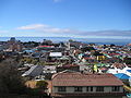
 Aerial view.
 -
 Sunrise view of the Strait of Magellan.
 -
 Plaque in El Magallanes newspaper building in Punta Arenas.
 -
 A view of the city's southern part from Cerro La Cruz
 -
 A view of the city's central part from Cerro La Cruz
 -
 One of many Croatian tombs at the town's municipial cemetery
 -
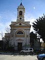 Cathedral of Punta Arenas


Notes
- ^ Interactive map, INE Census 2002, Chile. (Click on XII Region and then on Punta Arenas)
- ^ Punta Arenas, History and Legends.
- ^ History HMS Virago
- ^ Brown, Charles H., Insurrection at Magellan. Narrative of the Imprisonment and Escape of Capt. Chas. H. Brown, from the Chilian Convicts, published by Geo. C. Rand, Boston, Second Edition, 1854.
- ^ Punta Arenas example
Ushuaiaexample
Ushuaiaexample
Ushuaiaexample
Claim that New Zealand is still the jumping-off point for today's expeditions to Antarctica, and the home of several Antarctic research institutes.
Christchurch... is still the major jumping off point for Antarctica. It hosts the International Antarctic Centre, a place well worth a visit. - ^ a b Abarca, Jaime F (9 December 2002). "Skin cancer and ultraviolet-B radiation under the Antarctic ozone hole: southern Chile, 1987–2000". Photodermatology, Photoimmunology & Photomedicine. 18 (6). John Wiley & Sons A/S: 294–302. doi:10.1034/j.1600-0781.2002.02782.x.
{{cite journal}}:|access-date=requires|url=(help); Unknown parameter|coauthors=ignored (|author=suggested) (help)
Abstract.
"Background: Punta Arenas, Chile, the southernmost city in the world (53°S)"
", with a population of 154,000." - ^ Congreso Mundial Croata: Los croatas de Chile.
- ^ a b Punta Arenas article in Letsgochile.com
- ^ New York Times Punta Arenas Journal; A Hole in the Heavens (Chicken Little Below?) by Calvin Sims, 3 March 1995
External links
- portal de la ciudad
- Portal de la Ciudad
- Municipalidad de Punta Arenas
- La Prensa Austral
- Satellite picture by Google Maps
53°10′S 70°56′W / 53.167°S 70.933°W
Communes and municipalities in Magallanes y la Antártica Chilena Region | ||
|---|---|---|
| Última Esperanza |  | |
| Magallanes | ||
| Tierra del Fuego | ||
| Antártica Chilena | ||