Hrazdan
Hrazdan Հրազդան | |
|---|---|
 Hrazdan | |
| Country Marz | Kotayk |
| Established | 1959 |
| Government | |
| • Mayor | Aram Razmik Danielyan |
| Area | |
| • Total | 21 km2 (8 sq mi) |
| Elevation | 1,750 m (5,740 ft) |
| Population (2009) | |
| • Total | 52,900 |
| • Density | 2,519/km2 (6,520/sq mi) |
| Time zone | UTC+4 (GMT+4) |
| • Summer (DST) | UTC+5 (GMT+5) |
| Website | www.hrazdancity.am |
| Sources: Population [1] | |
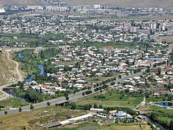
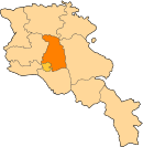
Hrazdan (Armenian: Հրազդան, also Romanized as Razdan; formerly, Akhta, Akhti, Akhtala, Nizhniye Akhty, Nizhne Akhti, Nerkin Akhta, and Nizhnyaya Akhta) is the capital of the Kotayk province of Armenia. The name Hrazdan is derived from the Middle-Persian name Frazdan. Farzdan is connected to the Zoroastrian mythology. With a population of 52,900 it is the fifth-largest city in Armenia by population. It has lost significant population since the 1989 census reported 59,000 people. During the Soviet years it was one of the highly-industrialized towns of the Armenian SSR.
Geography
The town of Hrazdan is situated in the north-eastern part of Armenia. From the North it is bordered with Pambak mountains, from the south-west with Tsakhkunyats mountains, from the east the border crosses Geghama mountains up to the top of Goutanasar mountain. Hrazdan River flows along the town, and the streamlets Marmarik and Aghveran flow into it.
The city is located on a height that ranges between 1600 and 1750 meters above sea level. The annual average temperature of the air is 6 °C. The amount of annual precipitation is 715–730 mm.
History
Hrazdan is one of the cities which have been established during the Sovite rule. The centre of Hrazdan region (former Akhta region) between 1930-59 was Akhta village, which is the southern district of the present-day Hrazdan town. In 1959 Akhta village was classified as a settlement of urban type of the Republic and in the same year it was renamed Hrazdan. With the order of the Supreme Soviet of the Armenian SSR, January 12, 1963 "About territorial changes in the Armenian SSR", the villages of Atabekyan, Jrarat, Kakavadzor and Makravan villages have been merged within the town of Hrazdan.[2] In fact, the town of Hrazdan was formed through the merger of a group of separate settlements. Thus, after becoming a town of regional dependence, Hrazdan started to change rapidly. During that period, the population of Hrazdan was approximately 61,000. The ancient inhabitants of the town were from the regions of Sasun, Kars and Mush of Western Armenia, and the regions of Maku, Salmast and Khoi of the present-day Iran, who arrived in the area between 1926-29. During the Soviet era, citizens from other regions of Armenia and Armenians from Diaspora were settled in Hrazdan.
In December 1995, Hrazdan became the centre of Kotayk province.
Industry
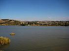
Hrazdan is one of the most industrialized cities in the Republic of Armenia. The city operates one of the biggest thermoelectrical power stations in the region. The hydro power station of Hrazdan lies on the shores of Lake Tsovinar. The cement factory of Hrazdan which has been put in action in 1970, is one of the largest enterprises in the Caucasus. Other types of industries in Hrazdan include: carpet manufacturing, production of electrical equipments, dairy products and cattle-breeding.
Education and culture


Hrazdan is home to one private higher educational institute, the Hrazdan Humanitarian Institute, which has 3 faculties: law, pedagogy and economics. Two intermediate colleges are operating in the town.
Currently, there are 13 public education schools, 13 nursery schools, 1 school for special needs and several special schools for music, arts and sports.
The second Human Rights Library Network (HRLN) library of the Armenian Constitutional Right-Protective Centre (ACRPC) was established in Hrazdan in 1998.
The community of Hrazdan are vigorously involved in cultural activities. The municipality runs the Hrazdan town Dramatic Theatre founded in 1953. The Hrazdan branch of the State Gallery of Armenia and the Geological Museum of Hrazdan are also run by the municipality. The third museum of the city is the History Museum founded by Armen Aivazyan, with more than 4,000 exhibits, some of which are 2-3 million years old.
Sites of interest:
- Aghbyurak Church of the 10th century.
- Surb Stepanos (Saint Stephen) Monastic Complex of the 10th century.
- Makaravan Monastic Complex of the 10-13th centuries, it has two churches: Surb Amenaprkich (10th century) and Surb Astvatsatsin (13th century).
- Surb Karapet Church of Jrarat built in 1831, currently under reconstruction.
- Surb Khach (Holy Cross) Church of Kojor built in 1861.
- Surb Mariam Astvatsatsin (Holy Mother of God) Church of Vanatur built in 1883.
- Lake Tsovinar with its surrounding parks.
- The rivers of Hrazdan, Marmarik and Aghveran.
Tsaghkadzor town-resort is located only 10 km north of Hrazdan.
Gallery
- Hrazdan
-
On the shores of Lake Tsovinar
-
Hrazdan railway station
-
Hrazdan football ground
-
Hrazdan as seen from Tsaghkadzor
See also
References
- ^ Armstats:Population Template:WebCite
- ^ "Hrazdan city official website: Historical overview". Archived from the original on 2011-01-11.
{{cite web}}: Unknown parameter|deadurl=ignored (|url-status=suggested) (help)
- Hrazdan at GEOnet Names Server
- Report of the results of the 2001 Armenian Census, Statistical Committee of Armenia


