
Sino-Korean Friendship Bridge
Sino-Korea Friendship Bridge | |
|---|---|
 | |
| Coordinates | 40°6′54″N 124°23′34″E / 40.11500°N 124.39278°E |
| Carries | road and rail traffic |
| Crosses | Yalu River |
| Locale | Dandong, • Liaoning Province, • and Sinŭiju, • North P'yŏngan Province, • |
| Official name | Traditional Chinese: 中朝友誼橋 Simplified Chinese: 中朝友谊桥 Chosŏn'gŭl: 조중우의교 Hancha: 朝中友誼橋 |
| Characteristics | |
| Material | Iron |
| Total length | 940.8 m (3,087 ft) |
| Location | |
 | |
| Sino-Korean Friendship Bridge | |||||||||||||||||
|---|---|---|---|---|---|---|---|---|---|---|---|---|---|---|---|---|---|
| Chinese name | |||||||||||||||||
| Traditional Chinese | 中朝友誼橋 | ||||||||||||||||
| Simplified Chinese | 中朝友谊桥 | ||||||||||||||||
| |||||||||||||||||
| Korean name | |||||||||||||||||
| Chosŏn'gŭl | 조중우의교 | ||||||||||||||||
| Hancha | 中朝友誼橋 | ||||||||||||||||
| |||||||||||||||||
The Sino-Korea, Sino-Korean, or China-North Korea Friendship Bridge (renamed from Yalu River Bridge in 1990) connects the cities of Dandong, China and Sinŭiju, North Korea. It was constructed by the imperial Japanese between April 1937 and May 1943, during their occupation of Korea and Manchukuo, to span the Yalu River. One of the few ways to enter or leave North Korea, it carries automobile and rail traffic. Pedestrians are not allowed to cross.
About 60 m (66 yd) downstream are the remains of an older bridge constructed between May 1909 and October 1911. It was an iron truss bridge of 12 spans on stone piers. The total length was 944.2 m (3,098 ft). The fourth span could be opened with a 90° horizontal rotation to allow easy navigation for tall ships. Both bridges were bombed by American aircraft during the Korean War. From November 1950 to February 1951, the United States used B-29 and B-17 heavy bombers, and F-80 fighter-bombers to repeatedly attack the bridges in an attempt to cut off Chinese supplies to the North Koreans. The bridges were repeatedly repaired. The 1911 bridge was left destroyed and only the newer 1943 bridge repaired and used at the end of the war. The North Koreans claimed that they did not want to rebuild the broken bridge so that the United States could not deny the fact they destroyed it. Four spans of the old bridge remained on the Chinese side of the river, giving it the name the "Broken Bridge" (断桥).
The bridges are flanked on the Chinese side by parks and promenades which make up the Yalu River Scenic Area. This is a major tourist attraction in China and is rated AAAA on China's national tourist scale. Tourist boats leave from the side of the bridge allowing visitors to view both bridges and the Dandong river front, and pass close to the North Korean waterfront. The four remaining spans of the old Yalu River Bridge were opened as a tourist attraction in 1993. Pedestrian walkways were constructed along the length allowing tourists to view the bomb damage close up. The Broken Bridge also allows good views across the river to Sinuiji on the North Korean side. In 2006 the Broken Bridge received protection as a key cultural relic by the State Council of China.
-
 Both bridges, view from mid river
 -
 The Beijing - Pyongyang passenger train regularly crosses the Sino-Korea Friendship Bridge
 -
 Crossing into North Korea on the Sino-Korea Friendship Bridge
 -
 Friendship Bridge view from Dandong China 2002
 -
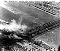 Aerial photograph taken in November 1950 during air attacks by American bombers shows damage to the Yalu River bridges


See also
- People's Republic of China – North Korea relations
- Foreign relations of North Korea
- Friendship Bridge
- Ji'an Yalu River Border Railway Bridge