
Cassis
Cassis | |
|---|---|
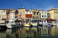
 Cassis from the Route des Crêtes, southeast of the town center | |
.svg) Coat of arms | |
Location of Cassis  | |
| Country | France |
| Region | Provence-Alpes-Côte d'Azur |
| Department | Bouches-du-Rhône |
| Arrondissement | Marseille |
| Canton | Aubagne-Est |
| Intercommunality | Marseille Provence Métropole |
| Government | |
| • Mayor (2008–2014) | Danièle Milon Vivanti |
| Area 1 | 26.86 km2 (10.37 sq mi) |
| Population (2008) | 7,793 |
| • Density | 290/km2 (750/sq mi) |
| Time zone | UTC+01:00 (CET) |
| • Summer (DST) | UTC+02:00 (CEST) |
| INSEE/Postal code | 13022 /13260 |
| Elevation | 0–416 m (0–1,365 ft) |
| 1 French Land Register data, which excludes lakes, ponds, glaciers > 1 km2 (0.386 sq mi or 247 acres) and river estuaries. | |
Cassis (French pronunciation: [kasi]; Occitan: Cassís) is a commune situated east of Marseille in the department of Bouches-du-Rhône in the Provence-Alpes-Côte d'Azur region in southern France.
It is a popular tourist destination,[1] famous for its cliffs (falaises) and the sheltered inlets called calanques. The wines of Cassis are white and rosé, and not to be confused with crème de cassis, a specialty of Burgundy which takes its name from blackcurrants (cassis), not the commune.
Geography

The town is situated on the Mediterranean coast, about 20 kilometres (12.4 miles) east of Marseille. Cap Canaille 394 metres (1,293 feet), between Cassis and La Ciotat ("the civitas") is one of the highest maritime bluffs in Europe, a sailor's landmark for millennia. It is east of Marseille and in the department of Bouches-du-Rhône.
History
The site where Cassis now sits was first occupied between 500 and 600 BC by the Ligures, who constructed a fortified habitation at the top of the Baou Redon. These people lived by fishing, hunting, and by farming.
The link with Massilia (Marseille),[citation needed] a city founded by the Phoceans,(Greek: Φώκαια), means that the current site of Cassis could have been inhabited by the Greeks, though no proof has yet been found.
During the Roman times, Cassis was part of the maritime route made by the Emperor Antoninus Pius. At this time, the port advanced right up to Baragnon. It was a small village, established mainly around the Arena and Corton beaches. The principal livelihood was fishing and maritime trade with North Africa and the Middle East. Several archaeological discoveries attest to this.[citation needed]
From the fifth to the tenth century, invasions by foreign tribes led the population to seek refuge in the castrum, a fortified city that, in 1223, became the property of the Seigneurie des Les Baux-de-Provence.
In the fifteenth century, Cassis was ceded to the Counts of Provence, then René of Anjou gave the town to the Bishops of Marseille, who ruled the town until the Revolution of 1789.
Industrial Revolution
In the eighteenth century, Cassis started to develop outside the ramparts of the fortified city and around the port. After the Bourbon Restoration, new industries developed here, including the drying of cod, the manufacture of olive oil and clothing, coral work, wine-making and the exploitation of local stone (cement, limestone). Stone of Cassis, which was quarried here since antiquity made the town famous. It has been used for the quays of the large Mediterranean ports (Alexandria, Algiers, Piraeus, Marseille, and Port Said and for the base of the Statue of Liberty in New York City.[2] Today, the stone is used more for domestic purposes such as the construction of sinks and fireplaces.[3]
In the twentieth century, as these industries began to disappear, the workforce turned to tourism and wine making. Cassis was one of the first three vineyards to profit from the appellation d'origine contrôlée (label of controlled origin) introduced in 1936.
Twin towns – Sister cities
Cassis is twinned with:
 Burnham-on-Sea, United Kingdom[4]
 Portofino, Italy
Notable residents
- Jean-Jacques Barthélemy, (1716–1795), writer and numismatist, was born in Cassis.[5]
- Henri Crémieux, stage and film actor, died at his house in Cassis. The Allée Henri Crémieux is named in his honour.[6]
- René Leriche (1879-1955), distinguished surgeon, died in Cassis. The Avenue du Professeur René Leriche is named in his honour.[7]
- Rudy Ricciotti (born 1952), architect whose works include the Musée des Civilisations de l'Europe et de la Méditerranée and the Jean Cocteau Museum, was resident in Cassis as of 2012.[8]
- Jean-Pierre Teisseire (born 1940), politician and retired professional football player, was the mayor of Cassis from 1995 to 2008.[9]
Population
| Year | Pop. | ±% |
|---|---|---|
| 1793 | 2,300 | — |
| 1800 | 1,878 | −18.3% |
| 1806 | 2,065 | +10.0% |
| 1821 | 1,846 | −10.6% |
| 1831 | 2,050 | +11.1% |
| 1836 | 2,065 | +0.7% |
| 1841 | 2,093 | +1.4% |
| 1846 | 2,069 | −1.1% |
| 1851 | 2,080 | +0.5% |
| 1856 | 2,187 | +5.1% |
| 1861 | 2,038 | −6.8% |
| 1866 | 1,975 | −3.1% |
| 1872 | 1,806 | −8.6% |
| 1876 | 1,809 | +0.2% |
| 1881 | 1,907 | +5.4% |
| 1886 | 1,879 | −1.5% |
| 1891 | 1,974 | +5.1% |
| 1896 | 1,956 | −0.9% |
| 1901 | 1,972 | +0.8% |
| 1906 | 1,980 | +0.4% |
| 1911 | 1,990 | +0.5% |
| 1921 | 2,193 | +10.2% |
| 1926 | 2,354 | +7.3% |
| 1931 | 2,434 | +3.4% |
| 1936 | 2,528 | +3.9% |
| 1946 | 2,769 | +9.5% |
| 1954 | 3,152 | +13.8% |
| 1962 | 3,611 | +14.6% |
| 1968 | 4,852 | +34.4% |
| 1975 | 5,831 | +20.2% |
| 1982 | 6,304 | +8.1% |
| 1990 | 7,967 | +26.4% |
| 1999 | 8,001 | +0.4% |
| 2008 | 7,793 | −2.6% |
Gallery
-
 Francis Picabia and friends at an outdoor café in Cassis
 -
 A quay in Cassis
 -
 Place Georges Clemenceau and château

.JPG)

See also
References
- ^ "Cu a vist París, e non Cassís, a ren vist!", "Who has seen Paris and not Cassis, has seen nothing!"
- ^ Harrell, Annelore (9 November 2011). "Foundation of our Statue of Liberty made from stone from Cassis". Savannah Morning News. Retrieved 20 January 2016
- ^ Auzias, Dominique and Labourdette, Jean-Paul (2011). Provence , p. 259. Petit Futé. ISBN 2746930498
- ^ "British towns twinned with French towns". Archant Community Media Ltd. Retrieved 2013-07-11.
- ^ Michaud, L. G.; Michaud, J. Fr., eds. (1843). "Barthélemy, Jean-Jacques". Biographie universelle, ancienne et moderne. Vol. tome III (nouvelle ed.). Paris: A. T. Desplaces. pp. 179–181.
- ^ Mirval, José (6 September 1980). "Artistes qui ont disparus!", p. 1. Sisteron-Journal. Retrieved via the Médiathèque of the City of Sisteron 20 January 2016 Template:Fr.
- ^ Archives de France. Commémorations nationales 2005: René Leriche. Retrieved 20 January 2016 Template:Fr.
- ^ Lanie Goodman (17 September 2012). "Ground Breaker", The New York Times. Retrieved 20 January 2016.
- ^ Maggio, Patrice (22 January 2012). "Teisseire: Le rois du sport, du politque, e du poker". Nice-Matin (re-printed in the Bulletin of the Association Généalogique des Alpes Maritimes, 1er trimestre 2012, p. 7). Retrieved 20 January 2016 Template:Fr.
External links
 Definitions from Wiktionary
 Media from Commons
 News from Wikinews
 Quotations from Wikiquote
 Texts from Wikisource
 Textbooks from Wikibooks
 Resources from Wikiversity
 Travel information from Wikivoyage
- Template:En icon French Riviera Cassis, Provence information website
- Template:En icon Tourism Office of Cassis
- Template:Fr icon Tourism Office of Cassis
- Template:En icon Town Website
- Template:Fr icon Town website
- Template:En icon Bird migration at Cassis