
Talk:United Nations
| This is the talk page for discussing improvements to the United Nations article. This is not a forum for general discussion of the article's subject. |
Article policies
|
| Find sources: Google (books · news · scholar · free images · WP refs) · FENS · JSTOR · TWL |
| This page is not a forum for general discussion about United Nations. Any such comments may be removed or refactored. Please limit discussion to improvement of this article. You may wish to ask factual questions about United Nations at the Reference desk. |
| United Nations has been listed as one of the Social sciences and society good articles under the good article criteria. If you can improve it further, please do so. If it no longer meets these criteria, you can reassess it. | ||||||||||||||||||||||||||||||||||||||||
| ||||||||||||||||||||||||||||||||||||||||
| This article is of interest to the following WikiProjects: | ||||||||||||||||||||||||||||||||||||||||||||||||||||||||
Template:Vital article
| ||||||||||||||||||||||||||||||||||||||||||||||||||||||||

.svg)


| This article is written in British English with Oxford spelling (colour, realize, organization, analyse; note that -ize is used instead of -ise) and some terms that are used in it may be different or absent from other varieties of English. According to the relevant style guide, this should not be changed without broad consensus. |
 | This article is substantially duplicated by a piece in an external publication. Please do not flag this article as a copyright violation of the following source:
|
| A fact from this article was featured on Wikipedia's Main Page in the On this day section on June 26, 2018. |
|
This page has archives. Sections older than 100 days may be automatically archived by Lowercase sigmabot III when more than 4 sections are present. |
Security council member list is wrong
I cannot edit it. Can someone do this please?— Preceding unsigned comment added by 2602:304:b1f0:4d80:9962:6dc2:81e7:3089 (talk • contribs) 00:43, 5 August 2018 (UTC)
- Done. Pilaz (talk) 14:36, 11 May 2019 (UTC)
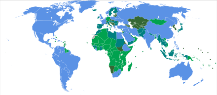
New Map
Ythlev recently included a map with many internationally unrecognized states on the UN wiki page. In my opinion, this is inappropriate as this is not the right place for such information as said states are not recognized by the UN. It completely contradicts the purpose and policies of the UN. I have removed it for said reason. Wadaad (talk) 11:14, 26 August 2019 (UTC)
- Let's start by pointing out that the map this user insists on using, with what it's trying to show, is not sourced. The source is a dead link and I see no proof that the UN considers Taiwan part of China or Kosovo part of Serbia.
- Then there is the question of what the map is even for. Wikipedia is not a means of promotion. It is for informing the reader of some knowledge. A map with all land coloured conveys close to no information. Most info-graphic world maps use de facto borders, so doing the contrary violates WP:UNDUE. From the section above, we can see that this 'UN perspective map' is utterly misleading. Ythlev (talk) 11:39, 26 August 2019 (UTC)
- Ythlev Taiwan and Kosovo only have limited recognition. Hence, why they are not included in the previous map. As for the dead link that can easily be fixed. Meanwhile your latest map includes Somaliland which is not recognized by any country whatsoever. It makes zero sense to include it on the UN wikipedia page of which it is not a member nor is it recognized by any UN member-state. Wadaad (talk) 12:34, 26 August 2019 (UTC)
As for the dead link that can easily be fixed.
Then fix it. Before you do, it is original research and violates WP:OR.It makes zero sense
. Content on Wikipedia is based on policies, not on what makes sense to you. Ythlev (talk) 13:26, 26 August 2019 (UTC)- The one that you are proposing is not sourced either. The long standing one is sourced http://archive.is/OYTRc and original research is allowed in commons it's not a wikipedia Project. Maps can be created from original research if there is no map presented. I think the long standing map is appropriate since this is about UN member States.--SharabSalam (talk) 14:46, 26 August 2019 (UTC)
- Where in that sourced link is there any mention of what territories belong to which countries? WP:OR: Wikipedia articles must not contain original research. WP:OI: Original images created by a Wikipedian are not considered original research, so long as they do not illustrate or introduce unpublished ideas or arguments. Colouring non-members that are de facto independent such as Taiwan and Kosovo violates WP:NOTPROMO and WP:UNDUE. Ythlev (talk) 15:39, 26 August 2019 (UTC)
The one that you are proposing is not sourced either
. It is. The members are in the sub-article. As for the borders, the map is derived from File:BlankMap-World.svg, which is based on CIA's 2005 political world map. Ythlev (talk) 16:02, 26 August 2019 (UTC)- YthlevI see. Okay. I have an idea. Why don't you upload the map over the old one. Click on "upload new version" then upload your map, that way it will change in all Wikipedia projects. It should be clear that there are nations that are not members of the UN. Your map show these states while the current one doesn't.--SharabSalam (talk) 19:46, 26 August 2019 (UTC)
- Ythlev & SharabSalam I have fixed the dead url.[1] As for Ythlev, please refrain from including unrecognized states on that map as this is not the appropriate page for it. Here is an example map of recognized UN states from a UN source.[2] Wadaad (talk) 20:21, 26 August 2019 (UTC)
- YthlevI see. Okay. I have an idea. Why don't you upload the map over the old one. Click on "upload new version" then upload your map, that way it will change in all Wikipedia projects. It should be clear that there are nations that are not members of the UN. Your map show these states while the current one doesn't.--SharabSalam (talk) 19:46, 26 August 2019 (UTC)
- The one that you are proposing is not sourced either. The long standing one is sourced http://archive.is/OYTRc and original research is allowed in commons it's not a wikipedia Project. Maps can be created from original research if there is no map presented. I think the long standing map is appropriate since this is about UN member States.--SharabSalam (talk) 14:46, 26 August 2019 (UTC)
- Ythlev Taiwan and Kosovo only have limited recognition. Hence, why they are not included in the previous map. As for the dead link that can easily be fixed. Meanwhile your latest map includes Somaliland which is not recognized by any country whatsoever. It makes zero sense to include it on the UN wikipedia page of which it is not a member nor is it recognized by any UN member-state. Wadaad (talk) 12:34, 26 August 2019 (UTC)
I still don't see what information from these two links support this map. The first link is just a list of members and makes no reference to territories. The example map in the second link has all land with the same colour, including Western Sahara and Antarctica, which contradicts the current map. Also the current map has the label "Taiwan", but not Kosovo. What exactly is implied here? Ythlev (talk) 00:08, 27 August 2019 (UTC)
- There are many UN related pages with world maps that all stick the UN member-state system. For example see the page on Treaty on the Prohibition of Nuclear Weapons. It would be inconsistent with what is already in place in UN related pages. Wadaad (talk) 10:04, 27 August 2019 (UTC)
- You mean this? It has Kosovo and Taiwan, so how is it consistent? Ythlev (talk) 00:09, 28 August 2019 (UTC)
- Ythlev I think your map is problematic as well. In Political status of Taiwan it says
"the position of PRC is that UN General Assembly Resolution 2758, which states "Recognizing that the representatives of the Government of the People's Republic of China are the only lawful representatives of China to the United Nations", means that the PRC is recognized as having the sovereignty of all of China, including Taiwan."
If we put your map in the infobox we would give undue weight to one point of view.--SharabSalam (talk) 10:43, 27 August 2019 (UTC)- I can't speak for all non-members, but for Taiwan in particular, most maps consider Taiwan separate from China.[1] Colouring it the same as China is giving undue weight. Giving undue weight doesn't mean picking one side or the other. Ythlev (talk) 00:01, 28 August 2019 (UTC)
- I am thinking we remove the map from the infobox. It doesn't seem as a representative image. We can start a request for comment and make three options, 1-Wadaad map 2-Ythlev map 3-no map in the infobox we already have their flag and it is enough representation.--SharabSalam (talk) 10:15, 27 August 2019 (UTC)
- I don't mind the map being removed, although this may be contentious in the future and may be re-added by users who miss it or think it is necessary. Most IGO pages like the AU, EU, NATO etc all have maps. However, one may argue that the UN is quite different from these IGOs. Wadaad (talk) 11:54, 27 August 2019 (UTC)
Map of the current UN member states by their dates of admission[2] 1945 (original members)1946–19591960–19891990–presentnon-member observer states

![[1]](https://commons.wikimedia.org/w/index.php?title=File%3AUnited_Nations_Members_%28green%E2%80%93grey_scheme%29.svg&type=revision&diff=363445969&oldid=324408029)
- What about this map? Is it okay? It is from this article.--SharabSalam (talk) 12:28, 27 August 2019 (UTC)
- It's okay. My main objection is that any map on this page, especially the introduction, should not contain unrecognized non-member-states. Wadaad (talk) 16:58, 27 August 2019 (UTC)
- What exactly do you mean by "not contain"? You mean not show the territory they control or not show the label or having or not having separate colours from claiming countries? The map is inconsistent on this. Ythlev (talk) 01:00, 28 August 2019 (UTC)
- It's okay. My main objection is that any map on this page, especially the introduction, should not contain unrecognized non-member-states. Wadaad (talk) 16:58, 27 August 2019 (UTC)
- Personally, I think the best solution is to list Palestine in its own color as a United Nations Observer State, list Taiwan as a former UN member, and list the remaining eight states with limited recognition separately. I've seen some comments that suggest that doing this would be confusing, but as a reader I have to admit that I've always been much more confused by the fact that Western Sahara is so often displayed as an empty, seemingly unclaimed swath of land. At the talk page for states with limited recognition, consensuses have consistently resulted in unambiguous guidelines for when it is and is not appropriate to list an entity as a state with limited recognition, so it has long been the case that exactly ten states are in this category: Abkhazia, Artsakh, Kosovo, Northern Cyprus, Palestine, Somaliland, South Ossetia, Taiwan, Transnistria, and Western Sahara. If the alternative is to display Western Sahara as an uninhabited gray zone, I think it's much better to display it in a unique color on the legend so the reader can learn about why exactly it is that it's displayed separately. In short: I suggest a color for official UN Observers (which already seems to exist), a color for UN former members, and one for the other 8 non-member de-facto independent sates. This would provide the reader with as much relevant information as possible, without being too cluttered or being too off topic from the original purpose of the map. 🙂 Vanilla Wizard 💙 21:41, 30 August 2019 (UTC)
- Vanilla Wizard Taiwan is a UN member via China (PRC),[3] Somaliland is a UN member via Somalia (Federal Republic),[3] most of the Western Sahara is controlled by Morocco except for a small segment of the interior, and many of those unrecognized micro-states are incredibly small and irrelevant to warrent a massive revamp of the UN map. This is a good world map source according to the UN.[3] Wadaad (talk) 08:22, 1 September 2019 (UTC)
- You've just repeated yourself without an explanation as to what information from these two links support this map. The first link is just a list of members and makes no reference to territories. Where is there any mention of Taiwan? The example map in the second link has all land with the same colour, including Western Sahara and Antarctica, which contradicts the current map. Also the current map has the label "Taiwan", but not Kosovo. What exactly is implied here? Ythlev (talk) 00:08, 27 August 2019 (UTC)
- I second Ythlev's confusion regarding what Wadaad is trying to convey by simply linking to a list of member states of the UN. Being "too small" and "irrelevant" is most certainly not a factor that we take into consideration when deciding whether or not to include information on a map whose sole purpose is to inform readers about the current status of various polities with regard to their membership or lack thereof in the United Nations. Vanilla Wizard 💙 21:39, 1 September 2019 (UTC)
- WP:ADVOCACY states:
Advocacy is the use of Wikipedia to promote personal beliefs or agendas at the expense of Wikipedia's goals and core content policies, including verifiability and neutral point of view. Despite the popularity of Wikipedia, it is not a soapbox to use for editors' activism, recruitment, promotion, advertising, announcements, or other forms of advocacy.
This page is about the United Nations and its member-states. It is not the place to have your personal biases be reflected in an article. Wadaad (talk) 10:02, 3 September 2019 (UTC)
 There is currently a discussion at Wikipedia:Neutral point of view/Noticeboard regarding an issue with which you all may have been involved. Thank you. Wadaad (talk) 12:15, 4 September 2019 (UTC)
References
- ^ "r/MapPorn". reddit. Retrieved 27 August 2019.
- ^ "Growth in United Nations membership, 1945–present". United Nations. 6 August 2015. Archived from the original on 25 June 2017. Retrieved 5 July 2017.
{{cite web}}: Unknown parameter|dead-url=ignored (|url-status=suggested) (help) - ^ a b https://www.un.org/en/member-states/
Removed map of growth of UN membership
The source given is a UN listing of member states with dates of admission. The list has many footnotes explaining complicated cases. For example, the two countries into which Germany was divided after WWII were admitted in 1973, and after reunification they merged into a single member state in 1990. There's a similar explanation concerning Yemen, which was admitted in 1947, then a different Yemen was admitted in 1967, and then they later merged into a single member state. The map over-simplifies and distorts the information in the source. Germany is shown as it exists today, color-coded to show that it joined the UN between 1960-1989. The UN would presumably not publish such a map because it might cause readers to have diminished confidence in the factual accuracy and reliability of UN documents. For the same reason Wikipedia should not publish it. NightHeron (talk) 12:31, 8 September 2019 (UTC)
- NightHeron, But Germany is a member and East/West Germany don't exist. How would you propose this could be improved? ―Justin (koavf)❤T☮C☺M☯ 17:51, 8 September 2019 (UTC)
- Koavf, A color-coded map is not an appropriate way to present information that spans several decades during which boundaries and even the identities of countries changed in complicated ways. Modern Germany is colored with the color label of 1960-1989, when it did not exist in the form shown. Such an over-simplified inaccurate visual representation might be OK for schoolchildren, but as far as I'm aware the UN would not express the data is such a way. Wikipedia policies such as RS and SYNTH require us to be faithful to the source and not distort or over-simplify it. NightHeron (talk) 18:25, 8 September 2019 (UTC)
Question about map edits
Koavf and I have been having a parallel discussion on Talk:Member states of the United Nations which we have agreed to move here in the hope of getting more input from other editors. On the page Member states of the United Nations I made two map edits (explained on the article's talk page): (1) making the map of current UN members look like the corresponding map on the page United Nations (in particular, removing editorial commentary in a footnote that dealt with UN policy on Taiwan) and (2) removing the historical map of admission to the UN. Those edits were reverted, although an edit similar to (2) on United Nations has not (yet) been reverted.
What I see as the main question is: When inserting a map in an article, how much can an editor simplify a source and/or write a caption that deviates from the source? This question is of particular concern when editorial simplification or deviation from the source has implications for sensitive and controversial issues. Both this talk page and the NPOV noticeboard have contentious discussions going on concerning the way maps deal with Taiwan, Palestine, etc. My hope is that we could avoid accusations of editor bias if maps stick more closely to their source. Input from other editors would be helpful. Thanks. NightHeron (talk) 12:16, 11 September 2019 (UTC)
- So far I have not seen any good arguments for the inclusions of the de facto blue scheme map. This is the wikipedia page of an official organization with specific member states who claim specific territories.[4] It is not the place to play around with de facto maps like elsewhere on wikipedia. I would like to hear from others. Wadaad (talk) 11:43, 22 October 2019 (UTC)
- It is a "club" with an official membership list. Thus unless they are officially recognized as members they should be (even indirectly on a map) listed as members.Slatersteven (talk) 12:31, 22 October 2019 (UTC)
Discussion regarding map on Neutral Point Of View Noticeboard
A new discussion on the map has been opened on the NPOV noticeboard.[5]
- Wikipedia good articles
- Social sciences and society good articles
- Old requests for peer review
- Wikipedia Did you know articles that are good articles
- GA-Class International relations articles
- Top-importance International relations articles
- GA-Class United Nations articles
- Top-importance United Nations articles
- WikiProject United Nations articles
- WikiProject International relations articles
- GA-Class organization articles
- Top-importance organization articles
- WikiProject Organizations articles
- GA-Class Human rights articles
- High-importance Human rights articles
- WikiProject Human rights articles
- GA-Class politics articles
- High-importance politics articles
- WikiProject Politics articles
- Wikipedia articles that use Oxford spelling
- Wikipedia articles that use British English
- Selected anniversaries (June 2018)