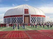
Mary, Turkmenistan
Mary, Turkmenistan | |
|---|---|
 Gurbanguly Hajy Metjidi | |
| Coordinates: 37°36′N 61°50′E / 37.600°N 61.833°E | |
| Country | Turkmenistan |
| Region | Mary |
| Government | |
| • Hakim | Kakageldi Gurbanov |
| Elevation | 223 m (732 ft) |
| Population (2009) | |
| • Total | 123,000 |
| Time zone | UTC+5 |
Mary (Turkmen pronunciation: [maɾɯ]), formerly named Merv, Meru and Margiana, is a city on an oasis in the Karakum Desert in Turkmenistan, located on the Murgab River. It is the capital city of Mary Region. In 2009, Mary had a population of 123,000,[1] up from 92,000 in the 1989 census.[2] The ruins of the ancient city of Merv are located near the city.
History
The ancient city of Merv was an oasis city on the Silk Road. It was occupied by Imperial Russia in 1884, triggering the Panjdeh incident between Afghanistan, British forces, and the Imperial Russian Army. The modern settlement was founded later that year as a Russian military and administrative post.
A force of the British Indian Army consisting of a machine gun detachment comprising 40 Punjabi troops and a British officer resisted the Bolsheviks near Merv in August 1918 in what was the first direct confrontation between British and Russian troops since the Crimean War.[3]
Mary was developed by the Soviet Union as a center for cotton production through the use of extensive irrigation. In 1968, huge reserves of natural gas were discovered 20 kilometers west of the city.[citation needed]
After the collapse of the Soviet Union and the proclamation of independence of Turkmenistan, on 18 May 1992 Mary became the center of Mary Province.
In the 2000s, the city accomplished the construction of many streets and large residential facilities. Mass housing construction still continues. The city has built the new airport terminal, a new building for the Turkmen State Power Engineering Institute, theatre, library, historical museum, the Ruhiyet palace, the "Margush" hotel, a medical diagnostic centre, the "Ene Myahri" medical centre, the mosque Gurbanguly Haji, a stadium, an equestrian complex, an indoor swimming pool and a railway station.[4]
In 2012, the city was declared one of the cultural capitals of the CIS.[5]
Economy
Mary is Turkmenistan's fourth-largest city and a large industrial centre for the natural gas and cotton industries, the nation's two major export industries. It is a trade centre for cotton, cereals, hides and wool.
Culture

Mary is known for its Regional Museum. The city lies near the remains of the ancient city of Merv, which in corrupted form gives its name to the modern town.
Sport
The main football team is Merw Mary who play at the Mary Stadium.
Notable people
- Akmammedov Myratgeldy, politician
- Khadyr Saparlyev, politician
- Yelena Bonner, human rights activist
- Eduard Asadov, poet and writer
Gallery
-
MiG monument in Mary
-
Mary Mosque (Gurbanguly Hajji Mosque)
-
Market in Mary, 1992
-
Market in Mary, 1992
-
Market in Mary, 1992
-
Bus stop,1992
-
Wedding in Mary, 1992
-
Women in Mary, 1992
-
Market in Mary, 1992
-
Man in Mary wearing a traditional telpek hat, 1992
International relations
Twin towns – Sister cities
Mary is twinned with:
References
- ^ Britannica Book of the Year 2009. Encyclopaedia Britannica, Inc. 2009. p. 719. ISBN 978-1-59339-232-1. Retrieved 17 December 2019.
- ^ Population census 1989 Archived 18 January 2012 at the Wayback Machine, Demoscope Weekly, No. 359-360, 1–18 January 2009 (search for Туркменская ССР) (in Russian)
- ^ On Secret Service East of Constantinople by Peter Hopkirk, John Murray, 1994
- ^ Гостеприимство древнего и вечно юного города
- ^ Туркменский город Мары получил сертификат культурной столицы СНГ


